|
Timberland Avenue is located along
the fringe of Brookline, off the lower end of Edgebrook Avenue. It runs almost
parallel to the South Busway, Saw Mill Run Creek and Rt. 51, on the southern
side of the train tracks. The street heads in the direction of the Liberty
Tunnels, but deadends far short of that destination.
There is also a smaller, lesser known
part of Timberland Avenue, located on the northern side of the train tracks
off of Rt. 51 near Bausman Street. This small section of Timberland lies
behind the Red, White and Blue Thrift store off of Saw Mill Run Blvd. There
is a small bridge that leads to a group of homes nestled below the train
tracks on the hillside along the creek. There was also a group of homes sitting
atop the hill, above the rail line.
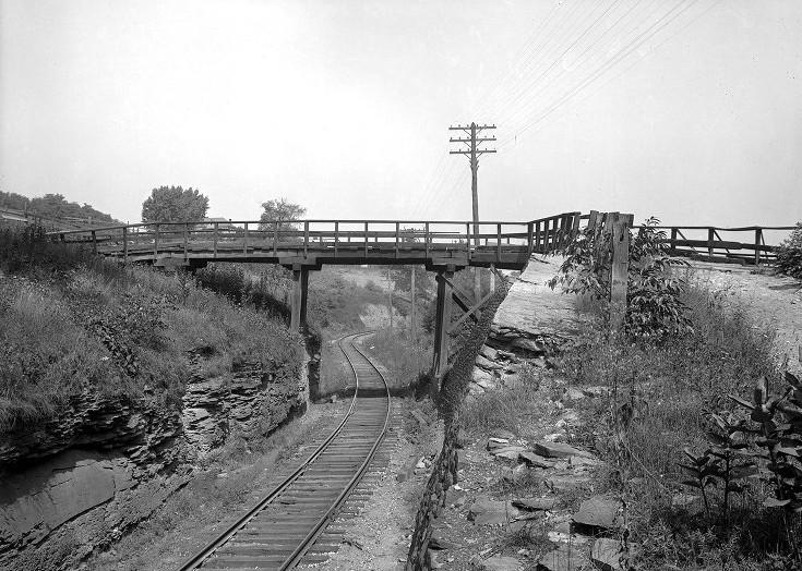
Back in October, 1909, the homes atop
the hill were disconnected from the main roadway. To get to Saw Mill Run
travelers had to cross over the train tracks using the large, rickety wooden
bridge in the upper left. At the time, there was a proposal to extend this
section of Timberland Avenue through a tunnel under the rail embankment and
up the hill to connect the homes above the rail line, where present-day
Lineal and Cadet Avenues are located. Eventually, plans included extending
Timberland to connect with the other section of the street that ran towards
Edgebrook. These proposals never came to pass, but the old photos of the
northern section of Timberland, behind the present-day Thrift Store are
interesting.
Click on images for
larger photos |
|
These are the homes up on the hill
that stood to benefit most from the roadway extension. At that time, their
only connection with Saw Mill Run Blvd was over the rickety bridge shown in
the photos above and below. Although this proposal did not come to pass,
their problems were solved with the construction of Cadet Avenue, which
connected them with the lower end of Pioneer Avenue. |
|
The bridge stood high above Timberland
Avenue and Saw Mill Run Boulevard. It offered travelers a nice view of Saw Mill
Run Valley and the hillside beyond. Below left shows the long row of homes on the
hillside above Saw Mill Run. Those homes were demolished in the early 1920s during
construction of the Liberty Tunnels. Below right shows the Bausman Street Bridge,
used by the Castle Shannon Railroad, rising above Bausman Street. |