|

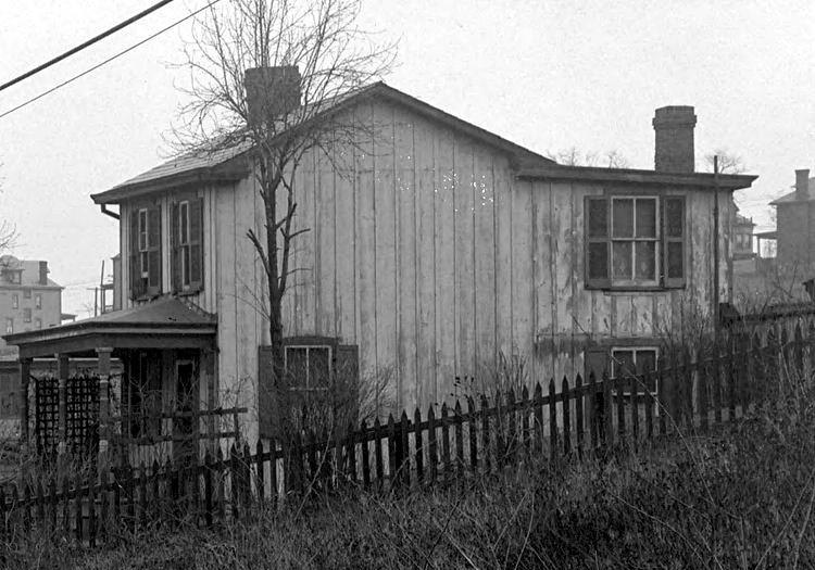
A cluster of West Liberty Avenue homes,
just north of Brookside Avenue, in March 1915.
The West Liberty Avenue improvement
project of 1915-1916 was one of the biggest efforts yet by the City of
Pittsburgh to modernize the newly annexed communities of Brookline and
Beechview. West Liberty Avenue was the central artery through what was
once West Liberty Borough. Heading north towards the city line at Dormont
from Warrington Avenue, the community of Brookline stood on the eastern side
and Beechview was to the west.
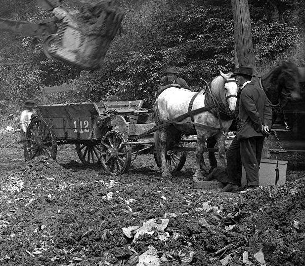
The project involved laying new sewers
and other infrastructure improvements, widening the roadway from two to four
lanes, upgrading the existing streetcar line and the installation of new
sidewalks and lighting. Shown here are a random collection of images beginning
in March of 1915.

Click on images
for larger pictures
<><><><> <><><><>
<><><><> <><><><>
<><><><> <><><><>
March 1915
 
Looking north from the city line near
Stapleton Street (left), and homes on the Beechview side.
West Liberty Elementary School, on Pioneer Avenue, is visible at the
top of the left photo.
Homes along the Brookline side near
Stapleton Avenue and the city line.
 
Looking north from the city line at Beechview
homes along West Liberty Avenue and Wenzell Avenue (left), and looking
south from the Brookline Junction. The building in the forefront is
Beinhauer's Funeral Home and family residence.
 
Looking north from the city line towards the
Brookline Junction (left) and surveyors working at the junction.
 
Looking south from the Brookline Junction
towards Dormont (left) and two boys sitting on a stack of wood, watching the
construction of the West Liberty Avenue sewer line. By 1915 the junction
had become a busy traffic intersection.
 
The Pittsburgh Coal Company power plant at
the Brookline Junction (left) and a trolley approaching Belle Isle Avenue. The
power plant was no longer in operation and would be demolished to make room
for the wide intersection at the junction.
 
A load of pipes sit at the intersection with
Saranac Avenue (left) and workers across from Belle Isle Avenue.
The men on the right are standing by the entrance to the present-day Wendy's
restaurant.
 
A billboard advertising new seven-room homes in
Robinson Place (left) and a home near Belle Isle Avenue.
 
Homes between Saranac Avenue and Pauline Avenue
(left) and a view of the roadway approaching Pauline.
 
A home at the intersection with Pauline Avenue
(left) and a view of the roadway approaching Ray Avenue.
 
Pedestrian traffic near Flander's General Store
(left), and a laundry (right), at the intersection with Ray Avenue.

Beechview homes north of Ray Avenue near the
bend leading to Capital Avenue.
 
Looking north towards the intersection with
Capital Avenue (left) and the Beltzhoover home at the bend leading to
Capital. The Beltzhoover residence was one of the many homes set
to be demolished during the reconstruction.
 
The Car Stop at the intersection with Capital
Avenue (left) and the walking board sidewalk across from Stetson Street.
 
Wagon and trolley traffic approaching
the intersection with Stetson Street. The streetcar is at the Stetson Car Stop.
 
Looking south at homes near Stetson Street (left)
and a view of the roadway looking south towards Capital Avenue.

Beechview homes along the hillside across
from Stetson Street.
 
A view from Stetson Street to Cape May Avenue
(left) and Bupp Contractor and Builder across from Cape May.
 
Two views towards Brookside, one from Cape May
northwards (left) and the other from Sauter Place southwards.
 
Homes above West Liberty Avenue at Brookside
(left) and a view from Brookside north towards Sauter Place.
 
Travelers passing Sauter Place (left) and
Pioneer Avenue (right) heading towards Warrington Avenue.
 
Workers rest near Pioneer Avenue (left) and
a view south towards Pioneer from Warrington Avenue.
A man stands at the Pioneer Avenue intersection
(left) and a view from Pioneer to Warrington Avenue.
 
Wagons loaded with construction materials near
Warrington Avenue.
 
Two views of a home that stood at the intersection
of West Liberty Avenue and Warrington Avenue. This home stood
in the path of the proposed new sewer line and would have to be moved in the
upcoming months.
<><><><> <><><><>
<><><><> <><><><>
<><><><> <><><><>
April 1915
 
Workers near the Brookline Junction. The photo on
the left shows the Knowlson Methodist Church, the oldest in Brookline.
 
Sewer line work near Belle Isle
Avenue.

One of the big Marion Steam Shovels
of Booth and Flinn Construction working near Belle Isle Avenue.
 
Sewer work near Brookside Avenue. The billboard
advertises "Beautiful Homes" in Brookline, only eight minutes away.
 
Workers in a sewer trench near Brookside
Avenue (left) and a home between Brookside and Sauter Place.

A home nestled next to the Pioneer Avenue
hillside, north of Brookside Avenue near the Sauter Place plan.
The hillside home is along the lower end of Pioneer Avenue and is still
standing today.
 
A wagon stands alone across from Sauter Place
(left) and the sewer trench running under the porch of the Shaffner home.
 
The Shaffner home near Pioneer Avenue (left)
and the West Liberty Hotel at the intersection with Warrington Avenue.
 
Work on the new sewer line near the intersection
with Warrington Avenue. In the path of the line is the Warrington home
that needs to be moved out of the way to get to Saw Mill Run creek. The
home was put on bricks and moved to the right.
 
Work on the new sewer line near the intersection
with Warrington Avenue.
 
A view of the sewer line looking towards Pioneer
Avenue (left); The home that stood in the path of the sewer was moved.
<><><><> <><><><>
<><><><> <><><><>
<><><><> <><><><>
May 1915
 
The old Knowlson Methodist Church (left) and
the Oyer home near the Brookline Junction.
 
The new sewer line near Cape May (left)
and ongoing trench work near Sauter Place.
 
Trench work near Sauter Place (left) and
an engineer stands in the new sewer line north of Pioneer Avenue.

A home in the Sauter Place plan, just
under the Pioneer Avenue hillside.
 
Engineers stand in the new sewer line (left)
and Theo Lau's produce store at Warrington Avenue.
 
The sewer line stretches from Pioneer Avenue
to Warrington (left) and the wagon works at the intersection.
 
A staging area next to the Shaffner home (left)
and the sewer line approaches Saw Mill Run Creek.
 
The Green and Evans Lumber Company at the
intersection with Warrington Avenue (left) and the end of the sewer line.
The hillside in the distance, once a quarry, will be the spot where the
Liberty Tunnels are cut.
<><><><> <><><><>
<><><><> <><><><>
<><><><> <><><><>
July 1915
 
Construction work at the Brookline
Junction.
 
A view from the Brookline Junction towards
Dormont (left) and Kerr's Practical Horseshoeing and Wagon Building.
 
Work on the sewer line near Pauline Avenue
(left) and north of Stetson Street.
 
Dooley's Meat Market at Stetson Street (left)
and homes north of Stetson on the Beechview side.
 
Homes (left) and sewer line work (right)
between Stetson Street and Cape May Avenue.

A view from Pioneer Avenue towards the
intersection with Warrington Avenue.
 
A brick layer sits on a pile of bricks near
Cape May Avenue (left) and workers near Brookside Avenue.
 
Construction workers near Brookside Avenue
(left) and Sauter Place.
Wagons await a load of gravel near
Sauter Place.
 
The railroad tressel (left) and
the Shaffner home (right) at Pioneer Avenue.
 
A special trolley car towing construction
materials and a Kaufmann's Delivery wagon (left) and
Elijah Lee's Horseshoeing and Wagon Building near the intersection with
Warrington Avenue.
 
A man sits near an outhouse (left) and a boy
stands at the end of the sewer line, near Warrington Avenue.
<><><><> <><><><>
<><><><> <><><><>
<><><><> <><><><>
August 1915
 
A view from the city line towards the
Brookline Junction, showing West Liberty Avenue homes.
 
A view from the Brookline Junction towards Dormont
(left) and a South Hills Ice Company wagon being repaired at Kerr's.
 
It's a busy construction and traffic
day from Belle Isle Avenue through to Pauline Avenue.
 
Workers toil on the streetcar tracks (left) and
the home at the intersection with Pauline Avenue.
 
Roadwork from Pauline Avenue north towards
Capital Avenue (left) and a laundry located at Ray Avenue.
 
Work on a gas line near Capital Avenue (left)
and traffic passing Stetson Street.
 
A view looking north from Stetson towards Cape
May (left) and the reverse angle, from Cape May south towards Stetson.
 
A view looking north from Brookside Avenue to
Sauter Place (left) and a home at the intersection with Sauter Place.
 
Trench work continues south of Pioneer Avenue
(left) and a view of the Pioneer Avenue intersection, looking north.
 
Two views of the Pioneer Avenue intersection,
looking north towards Warrington (left) and south from Warrington.
<><><><> <><><><>
<><><><> <><><><>
<><><><> <><><><>

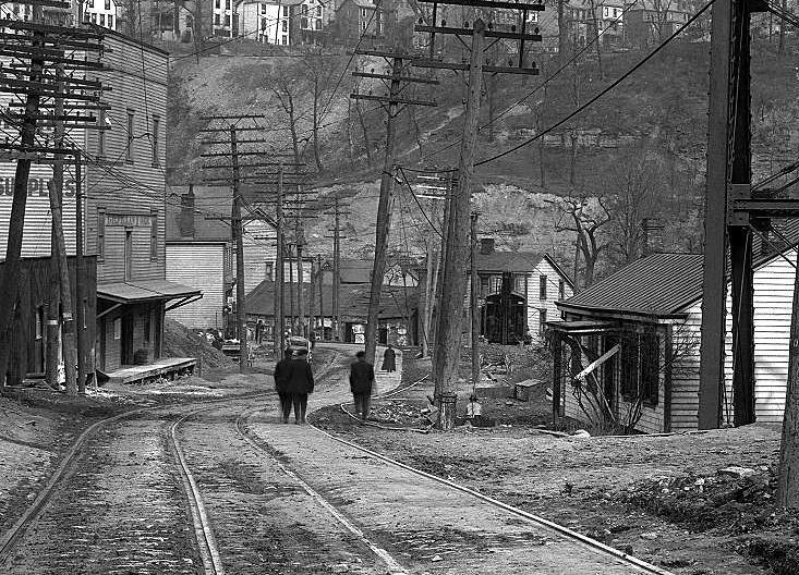
A view looking south towards the Brookside
Avenue intersection in April, 1915.
|