Pittsburgh's Golden Triangle
The Great Saint Patrick's Day Flood
March 17/18, 1936

The Golden Triangle - March 18, 1936

In mid-March of 1936, unseasonably warm temperatures caused snow and ice to melt along the upper Allegheny and Monongahela rivers basins. By Monday, March 16, the rivers rose to 21.7 feet and were beginning to overflow their banks, threatening the City of Pittsburgh.

On Tuesday, March 17, Saint Patrick's Day, the waters reached flood stage of twenty-five feet and had yet to crest under the current conditions. That evening, heavy rains led to one of the worst catastrophies in the history of Pittsburgh.

The Golden Triangle under water - 1936
The worst flooding in the history of the City of Pittsburgh occured on Wednesday, March 18, 1936.

The rain accelerated the snow melt and, by midnight, flood waters had risen to over thirty-four feet. The water inundated the Point and began working it's way into the downtown district. As conditions worsened, the rising tide caused major utility outages and a mass of refugees fleeing low-lying areas. Transportation ground to a halt, power and telephone lines were downed, and isolated fires began to rage. Amidst this confusion and chaos, water levels continued rising.

The Great Flood of 1936 -
Fifth Avenue and Market Street
A boat travels past the intersection of Fifth Avenue and Market Street in downtown Pittsburgh on March 18.

The flooding reached it's climax on the afternoon of Wednesday, March 18, when river levels peaked at forty-six feet plus four inches, the highest ever recorded in the city of Pittsburgh. By then, downtown Pittsburgh was under several feet of muddy, debris filled water.

Near the Point, water levels reached nearly fifteen feet, flooding the entire first floor of some buildings. This devastation was felt all along the Monongahela and Allegheny River, and the wave of destruction continued down the Ohio River basin.

The Great Flood of 1936 - Citizens
 being rescued from the flooded areas.
River rescues took place in the streets of Pittsburgh.

Although the waters began to drop during the evening hours of March 18, river levels in Pittsburgh remained above flood stage for another three days. The level dropped to thirty-two feet on March 19, and did not drop below flood stage until the 21st. Throughout the city, there was a severe shortage of palatable water.

Fear of epidemics and looting caused the downtown section to be placed under martial law. The National Guard and the State Police worked hard to keep order. Refugee centers were set up around the city and the Red Cross was on hand to give aid to those who had lost their homes.

A Red Cross nurse tends
 to one of the stranded children during the Great St. Patrick's Day Flood
A Red Cross nurse tends to one of the stranded children during the Saint Patrick's Day Flood.

During the crisis, over one hundred citizens perished, sixty-nine in the city of Pittsburgh alone. Nearly 3000 had been injured and more than 100,000 buildings were destroyed. Monetary damages were estimated at $250 million. Steel mills along the three rivers were severely crippled and over 60,000 steel workers were out of work. Sixty-five percent of the downtown business district was under water, from the Point all the way to Grant Street.

Meteorologists classify the 1936 event as a 500-year flood, one of the worst possible scenarios. Many surviving downtown buildings still have markers showing the height of the water during the Great St. Patrick's Day Flood of 1936.

Plaque on the Post-Gazette building downtown
showing the water level of the 1936 flood.
A plaque on the facade of the Post-Gazette building downtown shows the water level of the 1936 flood.

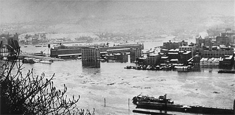
One positive outcome of the 1936 Flood is that the federal government finally allocated funding for a system of flood control reservoirs to be constructed above Pittsburgh. City officials had been petitioning for such action for nearly thirty years, since the Big Flood of 1907.

In the years since these flood control measures have been in place, Pittsburgh has seen a noticeable decrease in major flooding events, and hopefully will never again experience another riverborn catastrophe like that of March 17/18, 1936.

Post-Gazette article:
"The Historic St. Patrick's Day Flood of 1936: Two Eyewitness Accounts"

Universal Newsreels Video:
"Floods Sweep Cities In Western PA - 1936/03/18"

Wikipedia: Pittsburgh Flood of 1936.

On a personal level, my great grandfather Jayson Patrick Ferns was an Electrical Inspector for the City of Pittsburgh at the time of the historic Pittsburgh flood. He was responsible for boating around the city and checking on the electrical systems in the flooded city buildings.

<><><><> <><><><> <><><><> <><><><> <><><><> <><><><>

Images from the Saint Patrick's Day Flood

Click on images for larger photos

The Great Flood of 1936 -
The P&LERR Rail Yard.
The P&LERR Rail Yard and passenger boarding station along the Monongahela riverfront.

The Great Flood of 1936   The Great Flood of 1936
The City of Pittsburgh was devastated on March 18, 1936 as flood levels rose to a record 46'4."

The Great Flood of 1936 - Two
trolleys submerged along Penn Avenue.   The Great Flood of 1936 - The Pennsylvania
National Guard was called in to keep order
as the city was placed under martial law.
Two Pittsburgh Railways trolley cars almost totally submerged under flood waters along Penn Avenue (left);
Pennsylvania National Guardsman stands watch further up Penn Avenue near Ninth Street.

The Great Flood of 1936 - Jenkins Arcade   The Great Flood of 1936 -
Carson Street and Smithfield Street
The water level rose to almost to the height of the Jenkin's Arcade marquee (left);
A crowd gathers at Carson Street and Smithfield Street on March 18.

The Great Flood of 1936 - Wood Street.   The Great Flood of 1936 - Fifth
Avenue near Liberty Avenue.
Flooding along Wood Street (left) and Fifth Avenue near Liberty Avenue (right) on March 18.

The Great Flood of 1936 - Wood
and the Boulevard of the Allies.   The Great Flood of 1936 - Penn Avenue.
Wood Street and the Boulevard of the Allies (left) and Penn Avenue (right) on March 18.

The Great Flood of 1936 - Diamond
Street near Wood Street on March 18.   The Great Flood of 1936 - Ferry Street
near Water Street the morning of March 18.
Diamond Street near Wood Street (left) and Ferry Street near Water Street on March 18.

The Great Flood of 1936 - Liberty
Avenue near Ninth Street on March 18.   The Great Flood of 1936 - Market
Street at Fifth Avenue on March 18.
Liberty Avenue near Ninth Street (left) and Market Street near Fifth Avenue on March 18.

The Great Flood of 1936 - The P&LERR
terminal building near the Smithfield Street Bridge.   The Great Flood of 1936 - Liberty Avenue.
The P&LERR terminal building near the Smithfield Street Bridge (left) and flooding along Liberty Avenue.

The Great Flood of 1936 - Flooding
along East Carson Street on March 18.   The Great Flood of 1936 - Flooding
near the P&LERR railroad terminal.
Flooding along Carson Street (left) and the P&LERR terminal building.

The Great Flood of 1936 - Flooding
along East Carson Street on March 18.   The Great Flood of 1936 - Factories
flooded along the Monongahela River.
Flooding at Smithfield and Carson Streets (left) and flooded factories along the Monongahela River.

The Great Flood of 1936 -
The Smithfield Street Bridge.   The Great Flood of 1936 -
The Smithfield Street Bridge.
Flooding at the Smithfield Street Bridge and the P&LERR Rail Yard.

The Great Flood of 1936.
A sign on the front of Hornes Department Store.

The Great Flood of 1936 -
The P&LERR Rail Yard.   The Great Flood of 1936 -
The Liberty Bridge and Panhandle Bridge.
The Monongahela riverfront between the Smithfield Street Bridge and Liberty Bridge.

The Great Flood of 1936 - A small
barge is used to deliver U.S. Mail.   The Great Flood of 1936 - The corner of
Seventh Avenue and Liberty Avenue.
A small barge is used to deliver the U.S. Mail near the P&LERR terminal building (left);
Flood water at the corner of Seventh Avenue and Liberty Avenue on March 18.

The Great Flood of 1936 - Diamond
Street near Ferry Street on March 18.   The Great Flood of 1936 - First Avenue
looking east towards Wood Street.
Diamond Street near Ferry Street (left) and First Avenue looking east towards Wood Street.

The Great Flood of 1936 - Eighth
Avenue and Liberty Avenue on March 18.   The Great Flood of 1936 - Liberty
Avenue the morning of March 18.
Liberty Avenue was flooded from above Eighth Avenue (left) all the way to the Point.

The Great Flood of 1936 - Flooding near the
Brady Street Bridge and the J&L Steel Mills.   The Great Flood of 1936 - Water levels are near
the deck of the Smithfield Street Bridge on March 18.
Flooding along Second Avenue near the Brady Street Bridge and the Jones and Laughlin Steel complex (left);
Water levels are near the deck of the Smithfield Street Bridge as trolleys leave downtown on March 18.

The Great Flood of 1936 - The
P&LERR Rail Yard along Carson Street.   The Great Flood of 1936 - Flooding along
Reedsdale Street on the North Side.
The P&LERR Rail Yard along Carson Street (left) and flooding on Reedsdale Street on the North Side.

The Great Flood of 1936 - Water Street.   The Great Flood of 1936 - Damage
to the P&LERR boarding platform.
Water Street looking towards Smithfield Street (left) and damage to the P&LERR boarding platform.

The Great Flood of 1936.   The Great Flood of 1936.
A fireman rescues a stranded dog (left) while pedestrians peer out onto the flooded street.

The Great Flood of 1936.   The Great Flood of 1936.
An inspector makes his way along the flooded streets in a canoe.

The Great Flood of 1936.   The Great Flood of 1936.
Water gushes from a broken window at the Press building (left) and others climb a ladder to safety.

The Great Flood of 1936.   The Great Flood of 1936.
Flooding along the Allegheny River (left) and stranded employees of an office furniture store.

The Great Flood of 1936.
Flood waters engulf a factory along the Monongahela River.

<><><><> <><><><> <><><><> <><><><> <><><><> <><><><>

The Cleanup After The Flood

The Great Flood of 1936 - A houseboat
grounded on River Avenue and Vine Street.   The Great Flood of 1936 - Federal Street
near the Sixth Street Bridge.
A houseboat grounded at River Avenue and Vine Street (left) and Federal Street near the Sixth Street Bridge.

P&LERR Rail Yard on March 26, 1936
The P&LERR rail yard was still clogged with mud and debris eight days after the flood.

The Great Flood of 1936 - Cleanup
near the Exposition Building on March 20.   The Great Flood of 1936 - Cleanup
on Diamond Street on March 22.
The Exposition Building on March 20 (left) and cleanup along Diamond Street on March 22.

1st Floor Joseph Hornes
The ground floor of the Joseph Hornes building.

The Great Flood of 1936 - Cleanup
near the Exposition Building on March 20.   The Great Flood of 1936 - Cleanup
on Diamond Street on March 22.
Ruined garments outside the Joseph Hornes Department Store (left) and a grounded barge on the West End.

The Golden Triangle - July 1936
Pittsburgh in July, 1936, four months after the Saint Patrick's Day Flood.

<><><><> <><><><> <><><><> <><><><> <><><><> <><><><>

Pittsburgh's Golden Triangle in 1938

The Golden Triangle - 1938

<Historical Facts> <> <Brookline History>