|
Point State Park sits at the apex of the Golden Triangle, where the Monongahela and Allegheny Rivers meet to form the Ohio River. In colonial days, this was the location of mighty forts that were at the center of the conflict between the French and English for control of the region. Later, it was at the center of a conflict between the native Americans and the European settlers, traders and British soldiers who sought sanctuary within the protective walls of Fort Pitt. During the industrial age, it evolved into the center of the Pennsylvania Railroad's mighty shipping empire. History of Point State Park Today, Point State Park is once again at the center, this time of Pittsburgh's historical and cultural heritage. It is a place where people can connect with Pittsburgh's past and marvel at the picturesque vistas of the modern-day city. This thirty-six acre, tree-lined park is downtown Pittsburgh feature attraction. Click on images for larger photos.
Pittsburgh In The 1940s - The Smoky Steel City Since the earliest days of the city of Pittsburgh, it was known as the "Smoky City." During the colonial days of Fort Pitt, a sooty pale hung over the Golden Triangle from the use of coal as a primary heating source. As the town grew and industry flourished, the use of coal increased exponentially, and soon the entire region seemed to be covered in a toxic mix of smoke and ash. With the fires of the steel mills blazing day and night, some refered to Pittsburgh as "Hell With The Lid Off."
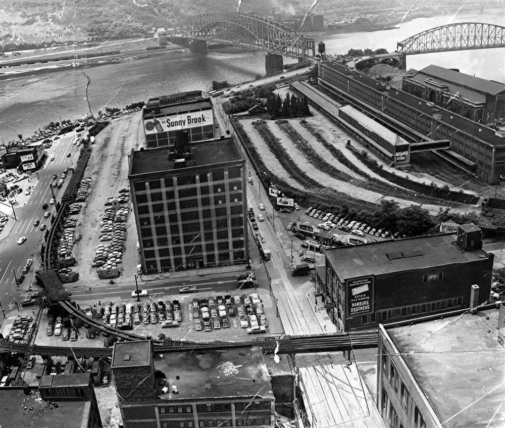
As the years went by, it became evident something needed to be done to change the face of the city. In the late 1930s, environmental legislation was passed to assist in cleaning the air and waterways. Attention also centered on the look of the city itself. Attention soon turned to finding a solution to the grimy outward appearance of the Golden Triangle landscape itself. In October of 1940, Mayor Cornelius Scully announced plans to build a state park on the land near the point. Once a bustling industrial area, by the early 1940s the tip of Pittsburgh's Golden Triangle had become a commercial slum.
It was the seen of rampant urban blight and rapidly deteriorating property values, largely occupied by the warehouses and freight yards of the Pennsylvania Railroad, along with seedy saloons, abandoned buildings and the downtown connecting ramps to the Point and Manchester Bridges. By the end of the decade, City Planners had decided the best way to proceed was to erase it all and start from scratch. Pittsburgh's Point would be completely rebuilt from the ground up.
The Moses Plan This renovation effort was just a part of a grand design by renowned New York architect Robert Moses, known as "The Moses Plan", that would not only transform the condition of the downtown area, but improve the entire landscape of the City of Pittsburgh. The Moses Plan included new and modern bridges, towering skyscrapers, civic and cultural development, and a vastly improved road network linking the city with the suburbs. The thirty-six acre Point State Park project and the adjacent twenty-three acre Gateway Center project were two of the major ingredients in the modernization and beautification effort that is commonly refered to in Pittsburgh history as Renaissance I.
Early Artist's Conception Of Point State Park The Pittsburgh Regional Planning Commission put forth the following proposal during the Point Development Study. The initial plans called for replicas of both Fort Duquesne and Fort Pitt to be built.
Park construction followed this original plan to a large degree, however the replica forts were toned down considerably and the fountain at the point took on a slightly different look.
Historical Renaissance and Urban Renewal The city began purchasing property in 1946. In all, 133 properties were purchased at a cost of nearly $8 million to acquire the entire sixty acres of the proposed redevelopment area. On May 18, 1950, demolition work began.
After ten years of planning, Governor Duff and Mayor David Lawrence were on hand to give the signal for the wrecking ball to begin the razing of a 103-year old abandoned home. From that moment on, land clearing proceeded at a rapid pace. By 1954, most of the buildings occupying the park area had been removed and preliminary construction work began.
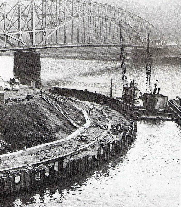
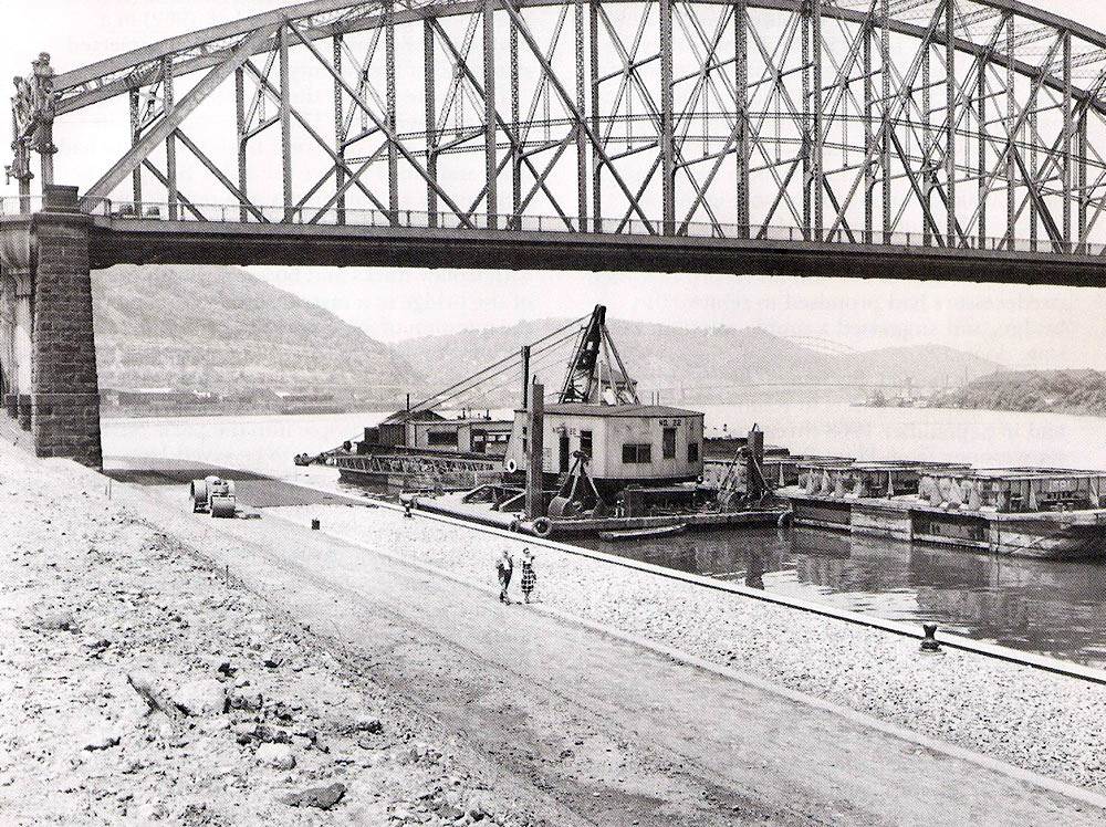
Retaining walls were built along the river's edge, followed by some grading and seeding of the park property. The roadways leading to the Point and Manchester Bridges were the left in place, but everything else, with the exception of the blockhouse and Caretaker's Residence, or the Blockhouse Lodge, had been removed. This initial preparation work was completed in 1956 and the park project was put on hold. After the construction of the Fort Pitt and Fort Duquesne Bridges, the Portal Bridge, and all of the connecting ramps between the two spans, had been completed in 1963, work once again resumed on park construction.
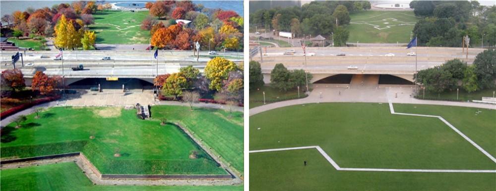
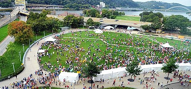
Pittsburgh's Point State Park would include ample green space and natural landscaping, including a Great Lawn, for recreation and other outdoor festivals. The park also featured the Portal Bridge and reflecting pond, paved promenades along the riverfront, and a stepped wall or stone bleacher section along the Allegheny River.
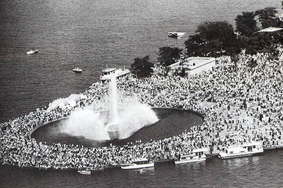
The park would be highlighted by a grand fountain at the tip of the Point. To represent the historical significance of the Point during the American colonial period, Point State Park included the Fort Pitt Museum and the Fort Pitt Blockhouse, replicas of two Fort Pitt bastions (including some of the original walls), a Fort Duquesne outline and several historical markers. For The Education and Enjoyment Of All The People By 1970, most of the park's main features were in place, with the exception of the tip of the Point, were the old Point and Manchester Bridge spans and cross ramps were still in place. The bridges were dismantled later that year, allowing for the final phase of park development to take place. Finally, on August 30, 1974, Pittsburgh Mayor Pete Flaherty, along with several other city and state officials, were on hand for the dedication of the signature fountain at the confluence of the three rivers, signalling the end of the thirty-four year effort to construct Point State Park. The park itself was re-dedicated for the education and enjoyment of all the people. <><><><> <><><><> <><><><> <><><><> <><><><> <><><><> Photos of the Final Phases of Construction (1969-1974)
Pittsburgh's Playground Since Point State Park's official opening in 1974, it has provided recreational space for workers, visitors, and residents in downtown Pittsburgh and also acts as the site for major cultural events in the city. It has become, in a manner of speaking, Pittsburgh playground. Major attractions include concerts, the Venture Outdoors Festival, Three Rivers Arts Festival, the Richard S. Caligiuri Great Race, First Night Festivities and Three Rivers Regatta.
Possibly the most anticipated yearly event is the Independence Day celebrations, when thousands upon thousands of visitors cram into the park for the annual Zambelli fireworks display. The fireworks spectacular is now the closing event of the Regatta. In 2006, the park attracted nearly two million visitors. Point State Park is a registered National Historic Landmark, operated by the Pennsylvania Bureau of State Parks.
Point State Park
Renovation In 2006, the Pennsylvania Department of Conservation and Natural Resources, announced a $25 million plan to renovate Point State Park. The plans called for improving the green spaces within the park, expanding recreational opportunities, preserving and enhancing historical structures, facility upgrades and other general improvements.
The major visual change was in the outer park area, on the city-side of the portal bridge, where the bastion walls and mote were removed in favor of a bastion outline and a continuous level lawn. This change made this part of the park more accomodating to larger gatherings. The majority of the this work was completed in time for Pittsburgh's 250th anniversary celebration in 2008.
The entire project, including new landscaping, refurbishing the Portal Bridge walkway and reflecting pool, upgrades to the museum, renovation of Point State Park's signature fountain and a number of other infrastructure improvements, was scheduled for the Spring of 2013.
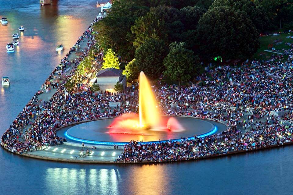
Finally, on June 6, 2013, the fountain was re-dedicated. City officials and spectators were treated to a spectacular laser light show to highlight of the event. A rainbow emanated from the fountain prior to the big event. When the water was turned on, the crowd marveled at the restored beauty of Pittsburgh's landmark attraction.
After nearly three years of inactivity, the Point State Park fountain once again soared skyward, marking the official completion of the renovation project. Pittsburgh's Point never looked better, and was once again the city's premier recreational playground and tourist destination.
Pittsburghers are fortunate to have such a wonderful park to visit for a relaxing walk along the riverside or to just sit down and admire the stunning visual displays of the landscape and features of the City of Pittsburgh.
Outline of Point State Park - Pittsburgh, Pennsylvania
Department of Conservation and Natural Resources: Point State Park. Wikipedia: Point State Park. The Fountain's Glacial Source
The fountain in Point State Park, which sprays water up to 150 feet in the air, draws upon fresh water from an aquifer that passes beneath the park known as the "Wisconsin Glacial Flow", an ancient river channel now filled with sand and gravel as a result of the glaciation and consequent re-routing of Pittsburgh's rivers. This Ice Age aquifer is often refered to as Pittsburgh's "Fourth River." This underground river is also the source of fresh water for several of the buildings in the Golden Triangle. The tapping of this water, which is crystal clear and naturally free of impurities, is one of the ways that the City of Pittsburgh is pursuing to bring new, and old, buildings into compliance with LEED green certification guidelines. Alternate Proposals for Development of Pittsburgh's Point Throughout the years, beginning in the early 1900s, there have been proposals put forth for development of Pittsburgh's Point. Some are quite elaborate and others a bit more reasonable, but all focus on the importance of The Point as one of Pittsburgh's most iconic locations.
|