|

The CVS Pharmacy, at the intersection of
Pioneer Avenue and Brookline Boulevard, opened it's doors in 2000.
The surrounding community of Brookline has a long heritage dating back
over 100 years.
The following is a series of drone images showing the community of Brookline. Shot in
the Fall of 2014 and Spring of 2015 by Matt Lackner, these high resolution
pictures were taken from various locations around the neighborhood.
They go a long way towards capturing the visual beauty and
make-up of Brookline from a bird's-eye perspective.
Click on images
for larger pictures
Brookline Boulevard
Veteran's Memorial
Engine House #26
Street Scenes
Churches/Schools
Liberty Tunnels
Moore Park
Brookline Park
A Short, But Sweet, Drone Video Of
Brookline
Brookline
Boulevard
Brookline Boulevard, in the
mid to late-1800s, was a dirt lane that ran along the northern edge
of the Knowlson Farm. The first stretch, from Plumers Run (West Liberty)
to Lang Avenue (Pioneer), was called Hunter Avenue (Bodkin). From Lang
Avenue through to Hughey Road (Edgebrook), Oak Street (Whited) and Fairhaven
Road (Merrick), the roadway was known as Knowlson Avenue.
Beginning in 1905, when the West
Liberty Development and Freehold Real Estate companies carved out the
original borders of Brookline from West Liberty Borough, the street
designation was changed to Brookline Boulevard. The neighborhood main
street soon became the cultural and commercial center of Brookline.
Brookline Boulevard has undergone
many changes over the past century. Throughout the 20th century and into
the new millenium, it has remained the heart of the community.
For more information on the history of Brookline Boulevard, click here.

The lower end of Brookline Boulevard runs left to
right through the center, past the Whited/Merrick intersection through towards
Breining Street and the East Brookline area. Beyond Breining, the boulevard
continues as a two-lane roadway to Jacob Street.
For many years, the city line and Brookline border ran from Whited Street along
Brookline Boulevard and to the right
at Breining. The land north and east of that line was part of Overbrook Borough.
These homes became part of
the Brookline census tract in 1930. Visible in the distance to the north is
the USX Tower, located in
downtown Pittsburgh. The Steel Building is tallest structure between Chicago and
New York.

Looking northwest along Brookline Boulevard
from near Queensboro Avenue. Much of the land shown here was part of
the vast Knowlson Farm. When the West Liberty Improvement Company
began building Brookline in 1905, this
was the heart of the planned community. Visible are Brookline's 1st, 2nd and 3rd Ward developments.

Looking southeast from near Flatbush
Avenue towards the Veteran's Memorial Park and Chelton Avenue. The Mazza Pavilion
apartment building off to the right first opened in 1982.
It replaced four buildings destroyed in a 1973 fire. The interior
and exterior were completely renovated in 2011. To the lower right is the
former Brookline Savings And Trust Company.

Looking southeast along the Brookline Boulevard
Commercial District from the 700 block. The building on the lower right was
once the Brookline Theatre. The movie house was in business from 1910 to 1945. Today it
is home to the Brookline Pub.
Brookline Boulevard actually had two movie theatres. The Boulevard Theatre (1937-1952) was located between
Flatbush and Stebbins Avenues, a bit further down the road. That building is now occupied
by Compulink.

Looking northwest along Brookline Boulevard
from the 700 block towards the firehouse and Castlegate Avenue.
From February 2013 to July 2014, the boulevard underwent a $5.35 million reconstruction.
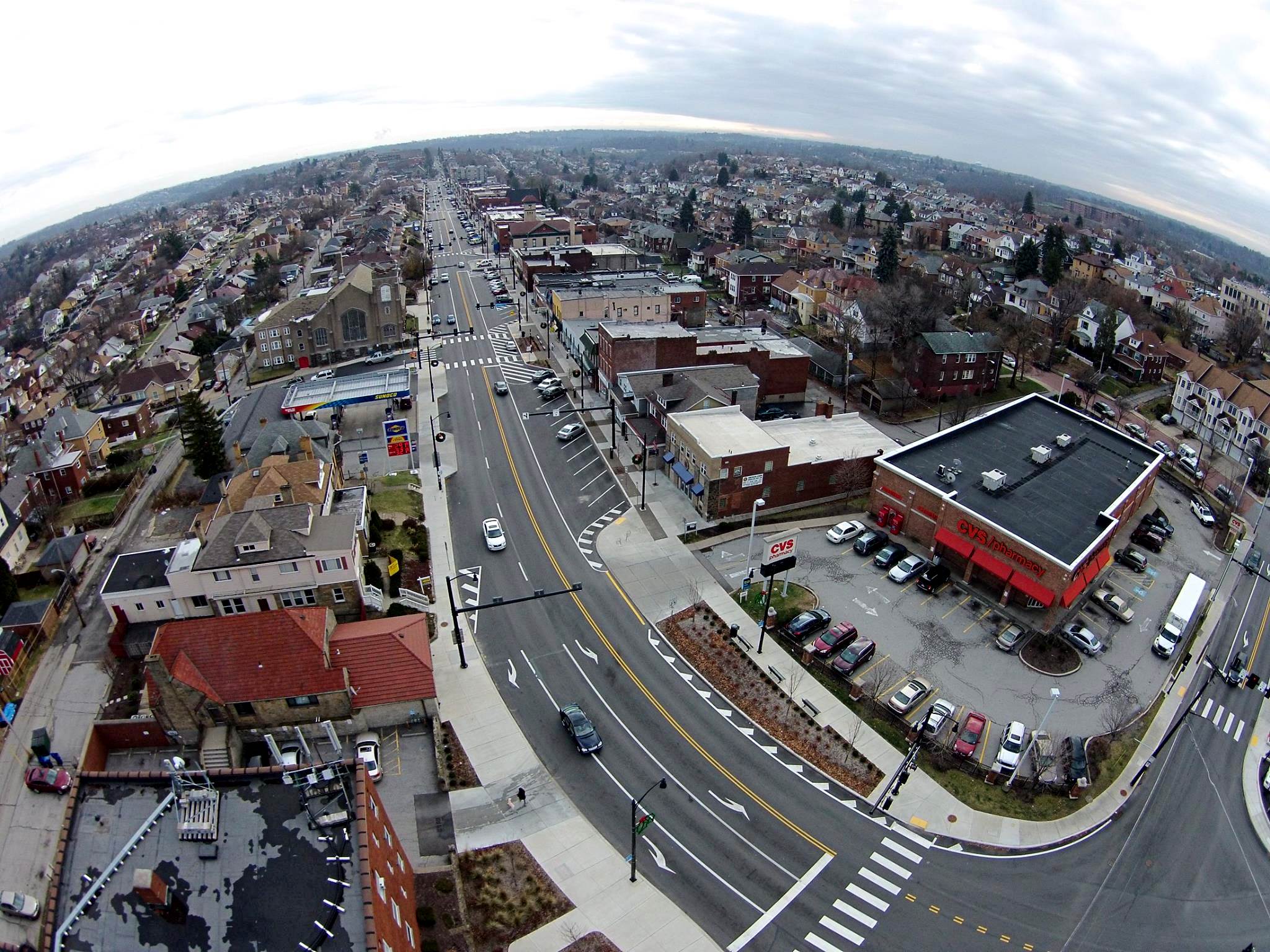
Looking to the southeast along the Brookline
Boulevard Commercial District from the intersection with Pioneer Avenue.
From 1905 until 1966, the route of the 39-Brookline streetcar ran down the center of the broad
thoroughfare.
In 1999, four vintage buildings and two homes along Berkshire
Avenue were razed to build the CVS Pharmacy.

Looking to the east from the intersection
of Brookline Boulevard and Pioneer Avenue. The Community of Brookline was formed
in 1905. It became part of the City of Pittsburgh when West Liberty
Borough was annexed on January 4, 1908.

Looking southwest along Pioneer
Avenue from the Brookline Boulevard intersection. The Boulevard Loop
heads downhill to the right.
The dead-end street to the far right is Bodkin Street, which prior to 1935 was designated part of Brookline
Boulevard.

Looking southeast from above the Brookline
Junction at Bodkin Street (left) and the Brookline Boulevard Loop. The looping
section of the roadway was once a Pittsburgh Railways right-of-way, used by streetcars only. In 1935 the loop
was
widened and paved. The boulevard was then rerouted off of Bodkin
Street. Some of the homes inside the loop,
and to the right of the loop, are part of the Fleming Place Plan. They were constructed around 1902.

The Brookline Mural stands along the
looping portion of Brookline Boulevard, just below Jillson and Shawhan Avenues.
The retaining wall was originally built in 1935. The decorative mural was painted
by Jennifer Rempel in 1996.

Looking northeast from the Brookline Junction. West Liberty Avenue, which runs along Plumer's Run Creek, was first
laid out in 1839. The broad avenue forms the border between the Beechview
and Brookline communities.
Prior to 1908, it was the main road that ran through the center of West Liberty
Borough.
Veteran's Memorial
And Cannon
The Brookline Veteran's Memorial
and Cannon sit in a triangular-shaped island bordering Brookline Boulevard,
Queensboro Avenue and Chelton Avenue. On the city register, this small
piece of land is known as Brookline Boulevard Triangle Park.
From 1905 until 1932, this was
the site of the Freehold Real Estate Company's Brookline office. When
the office was closed, the land was bought by James J. McGaffin. a
prominent Brookline businessman. It was subsequently sold, in April
1934, to the city for the purpose of creating a memorial to veteran's
of the Great War.
The park was initially dedicated
in 1935 by Brookline's American Legion Post#540, then re-dedicated in 1946
to include those who served in World War II. Finally, in 1992, the park
was dedicated once more, this time with a monument that includes veterans
of all conflicts.
One of the park's most recognizable
features is the World War I artillery piece that stands along with the
veteran's monument. For more information on the Brookline War
Memorial, click here.

Brookline's
Engine House #26
For over 100 years, one of the
most identifiable buildings along Brookline Boulevard has been the firehouse,
with it's tall hose tower. Originally designated as PBF Engine House #57,
the firehouse now carries the numerical designation 26. The firefighters who
have served at the historic station have worked hard over the past century
to help protect the lives and property of the residents of Brookline.
For more information on the history of the Brookline Firehouse, click here.


Street
Scenes
The community of Brookline is known
for it's long rows of tightly-packed homes, built on streets that stretch
along the rolling hills. Several of the houses date back to the early-1900s.
Many others were built in the 1920s, 1940s and 1950s.
The following aerial images were
shot from various vantage points around the community. The photos show
most of the streets, alleyways and homes located in Brookline.
A comparison of local maps dating from the 1870s through to the present-day reveal a lot
about how, and when, the streets that criss-cross the neighborhood were
developed. These hillside homes and broad avenues are one of the features
that give the Brookline community it's unique charm. For more information
and old photos of different locations throughout Brookline, click here.
Bayridge Avenue and Queensboro Avenue

....

....

....

....
Beaufort Avenue and Metz Way

....

....

....
Berkshire Avenue and Queensboro Avenue

....

....

....

....
Beaufort Avenue and Berwin Avenue

....

....

....

....

....
Belle Isle Avenue and Plainview Avenue

....

....

....

....

....
Wolford Avenue and Berwin Avenue

....

....

....
Rossmore Avenue and Wedgemere Avenue

....

....

....

....

....
Milan Avenue and Witt Street

....

....

....

....
Milan Avenue and Gallupe Drive

....

....

....

....
Milan Avenue and Roswin Drive

....

....
Creedmoor Place and Seaton Street

....

....

....

....

....
Eben Street and Harcor Drive

....

....
Eben Street and Merrick Avenue

....

....

....
Sussex Avenue and Fortuna Avenue

....

....
Creedmoor Avenue and Oakridge Street

A view to the northeast showing homes
in East Brookline. Among the streets visible are Wareman Avenue, Clippert
Avenue,
Oakridge Street, Merrick Avenue, Whited Street, Brookline Boulevard and
Bellaire Place.
Pioneer Avenue and Woodbourne Avenue

Looking southeast along Berkshire and
Woodbourne Avenues from a point near Pioneer Avenue and Brookline
Elementary School.
Berkshire Avenue and Castlegate Avenue

A view to the east from a point above
the intersection of Castlegate and Berkshire Avenues.

Berkshire Avenue, with its vintage red
paving blocks, stretches off to the southeast from Castlegate Avenue. The Brookline
area is known for it's many small streams that originate naturally from the ground
itself. One of the largest was the
Great Brookline Spring, which originated between Castlegate and Stebbins and
followed the contours of the land
all the way to Saw Mill Run Creek. The stream was eventually diverted into
the storm water system.

Castlegate Avenue, from Berkshire Avenue
to the distant Brookline border at Dorchester Avenue.
Dunster Street and Ferncliff Avenue

Looking west from above the Pioneer Learning Center
at the lower end of Dunster Street, with a view of Dunster,
Mayville Avenue, Fernhill Avenue, Ferncliff Avenue and Crysler Street.
Mayville Avenue and LaMoine Street

A view to the west from LaMoine Avenue, showing
Fernhill Avenue, Mayville Avenue and Dunster Street. These homes are part
of the Paul Place Plan. The housing tract was built on land formerly owned by Mrs.
Elizabeth Paul. The Paul family's vast
estate once covered over 500 acres, stretching from LaMarido Avenue north to the
lower end of Pioneer Avenue.
The Paul's operated a large farm and later had a successful coal mining venture
along West Liberty Avenue.
Pioneer Avenue and Crysler Street

Looking to the east along Crysler Street
from the intersection with Pioneer Avenue. West Liberty School stands in the
distance.
Southcrest Drive and Linda Drive

The apartments along Southcrest Court,
along with homes on Southcrest Drive and Linda Drive. Many of these homes
were built in the early-1950s to house the displaced residents of Pittsburgh's
Lower Hill District.

Looking northwest with a view of Southcrest
Drive and Linda Drive. In the distance to the left are the south portals
of the Liberty Tunnels. Also visible is the Shannon-Drake light rail line along the Mount Washington hillside.
The southern light rail route has one stop located in Brookline, at South Bank
Station along Jacob Street.
Sussex Avenue and McNeilly Road

Looking northwest from the intersection of
McNeilly Road (left) and Sussex Avenue (right). The hillside homes along Donaldson
Drive are in neighboring Baldwin Township. Sussex Avenue is one of the major gateways
into Brookline.

Looking north along Sussex Avenue from the
intersection with McNeilly Road. The first street on the right is Cedric Avenue,
which forms the border between Brookline and Baldwin. Also shown are
homes along Perri Drive and Beltran Avenue.

A view to the south showing the intersection of
Sussex Avenue and McNeilly Road. The community of Brookline straddles
McNeilly Road at two locations. During these short stretches, the road designation is
McNeilly Avenue. Other
sections of McNeilly Road lie within the boundaries of Overbrook, Baldwin Township or
Mount Lebanon.

Looking west along McNeilly Road from the
intersection with Sussex Avenue. Early colonial surveys show this land
originally belonging to Revoluntionary War veteran John McKee, who went on to
found the town of McKeesport.
Midland Avenue and Dorchester Avenue

A view to the north showing Midland,
Dorchester and Knowlson Avenues. Brookline Elementary School stands in the
distance.
McNeilly Avenue on the far left, and Dorchester Avenue on
the bottom, form the city line and border of Brookline.

A view to the east showing the old DePaul
Institute complex, the Salvation Army Center and Devonshire Apartments.
These buildings are located across the community line in Mount Lebanon. Dorchester
Avenue forms the border
of the Brookline community in this location. All of the homes shown to the left
are part of Brookline.
Depaul Institute was a nationally-renowned school for the hearing impaired
from 1908 to 2003.
Where the Devonshire Apartments stand was the site of Toner Institute from 1941 to 1977.
Pioneer Avenue and Cadet Avenue

Looking southward from the Liberty Tunnels
Interchange. The W&LERR tracks, South Busway and Cadet Avenue head left while
Pioneer Avenue leads uphill into Brookline. To the right is the lower portion of
West Liberty Avenue and the Busway ramp.
From 1797 until 1909, the path of Pioneer Avenue continued straight down to the
intersection with Saw Mill Run.
When the railroad line was upgraded, the bottom portion of the road was diverted
to West Liberty Avenue.
In the early-1800s, Pioneer Avenue was the official State Road south from Pittsburgh
to Washington.

Looking to the south, Cadet Avenue (left) and Pioneer
Avenue (right) form a 'V' straddling the London Towne Apartments.
Where the apartment complex now stand was once the Lang estate. A large farmhouse stood along Pioneer Avenue
for many decades. The Lang family were prominent landowners. Pioneer Avenue was once
called Lang Avenue.

Looking southeast along Cadet Avenue towards
homes along Cadet, Lineal and Leavitt Avenues. This small cluster of homes
on the hillside above the W&LERR tracks contains some of the oldest in Brookline.
Once isolated on the other side of
the railroad tracks, these homes gained access to Saw Mill Run via a rickety wooden bridge that spanned
the tracks and connected to the small strip of Timberland
Avenue by the homes in the lower left.
The first coal mine in Brookline was opened in the 1870s, and located in the
wooded valley
behind the housing plan. The shaft opening was around the bend in the railroad
line.
Brookline Boulevard and West Liberty Avenue

West Liberty Avenue (left), heading north
towards downtown Pittsburgh. Bodkin Street (right) heads uphill towards the
dead
end at Brookline Boulevard. In between West Liberty and Bodkin are some
homes from the original Hughey Farms Plan,
constructed around 1902. From 1905 to 1935, Bodkin Street was considered
part of Brookline Boulevard.

Part of the Brookline Boulevard Loop
(left) and West Liberty Avenue, heading south towards Dormont. Homes along
Amman Street and Waddington Avenue are visible to the south, as well as
the St. Pius X parish grounds.

West Liberty Avenue, from near the Dormont
border (left) to the Brookline Junction (lower right). Across from the
Junction is Wenzel Avenue and Vodelli Street, both heading uphill towards Broadway
Avenue in Beechview.
The large building in the center is Beinhauer Funeral Home, which first opened
for business in 1910.
Bayridge Avenue and Castlegate Avenue

Looking northeast along Castlegate Avenue
from a point above the Castlegate/Bayridge intersection.
The homes on this side of the boulevard are part of Brookline's 1st Ward subdivision.

Looking east at homes along Bayridge, Woodbourne
and Berkshire from above the Castlegate/Bayridge intersection.
Several of the homes dotting the Brookline landscape were purchased
through the Sear's Modern Homes Catalog.

Looking southeast along Woodbourne and
Bayridge Avenues from a point above Castlegate Avenue. Near the intersection
of Bayridge and Castlegate, Brookline stands 1250 feet above sea level. This
is the third highest spot on the map.
The air is thinnest along Creedmoor Avenue, between Oakridge and Freedom, where
the altimeter tops out
at 1275 feet. The second highest location is at the apex of Roswin Drive, topping
off at 1260 feet.
Castlegate Avenue and Fordham Avenue

Looking southeast along Fordham Avenue towards
Queensboro. Running parallel to Fordham are Bayridge and Norwich Avenues.
From Dorchester Avenue on the right to Brookline Boulevard on the left was all part of
the vast Knowlson Farm.
The Knowlsons moved to the area from New England in the mid-1850s. Family members
farmed the land
until the turn of the century. Richard Knowlson is credited with coining the name
"Brookline."

Looking northwest along Fordham Avenue
from Castlegate Avenue. Also visible are Midland, Clemesha and Knowlson Avenues.
Prior to 1920, these were all dirt roads with wooden plank sidewalks. Most
travel was by horse-drawn wagon, or on foot.
Commuters walked to the nearest trolley car stop along the boulevard. By the
mid-1920s most streets were paved.
To the right, in the rear of Brookline School, once stood a baseball field.
Most of that land is now a parking lot.
The field was the scene of many memorable occasions. In the 1920s and 1930s
it was the location of the
annual Independence Day festival and fireworks. School day events included
this 1947 square dance.
Rossmore Avenue and Flatbush Avenue

Looking west from above Flatbush Avenue at
homes along Bellaire, Rossmore and Wedgemere Avenues. Part of Gallion Avenue
is visible in the upper right. Bellaire and Rossmore both continue on to Pioneer
Avenue. In the distant rectangular area
bordering Pioneer, Gallion, Wedgemere and Rossmore was the site of Brookline's
first park, which stood until
the early 1920s. The land was divided in two. From Pioneer Avenue down to the
midway point was the
site of the Brookline School garden. On the lower half stood a baseball field and picnic area.
The 1914 Brookline sandlot team that played there won the Pittsburgh city
championship.
Bellaire Avenue and Flatbush Avenue

Looking northwest along Bellaire Avenue from
above Flatbush Avenue. The homes along Bellaire, and to the right, were part
of Brookline's 2nd Ward subdivision. Many of the homes date to 1907. The Greentree water tower stands
in the distance.

A view to the east from above Bellaire Avenue
that shows Flatbush Avenue as it runs from Bellaire through to Rossmore,
Gallion and Berwin Avenue. The entire length of Flatbush is paved in belgian
block. At one time nearly all of the
local streets were covered in either the granite setts, or with red, beige
and gray paving bricks. Over
the years most of these streets have been paved over with asphalt. The
old bricks form the base.

Looking southeast with a view of Bellaire,
Rossmore, Glenarm, Starkamp and Edgebrook Avenues. The long avenue in the
distance is Creedmoor Avenue. Interestingly, the third longest
street in Brookline is Fitch Way, shown to the right.
It is the alleyway passing between the boulevard and Bellaire Avenue, running 1.29 miles
from Pioneer Avenue to
Witt Street in East Brookline. The longest neighborhood streets are Brookline
Boulevard (2.21 miles) and
Pioneer Avenue (2.17 miles). Edgebrook Avenue (1.25) and Whited (1.24) round
out the top five.
Churches and
Schools
Residents of Brookline have been
served by several churches and schools. Some of these parishes and
learning institutions have distinguished historys that date back to
the early-1900s. Throughout the years, these institutions have worked
hard to meet the spiritual and educational needs of the community.
For more information on the history of our neighborhood churches and
schools, visit Brookline Churches and Brookline Schools.

The Brookline Boulevard United
Presbyterian Church (1900-present). The present-day church was built in three
stages.
The Old Chapel was erected in 1912. The New Sanctuary rose in 1924,
and the Education Building added in 1953.

The Church of the Resurrection (1909-present).
Resurrection Elementary School (1912-1996). The original Church/School
was built in stages from 1909 to 1928. The Church building rose in 1939.
The school annex was added in 1957 and
expanded in 1965. The old school building was renovated in 2004 and is now
Creedmoor Court Apartments.

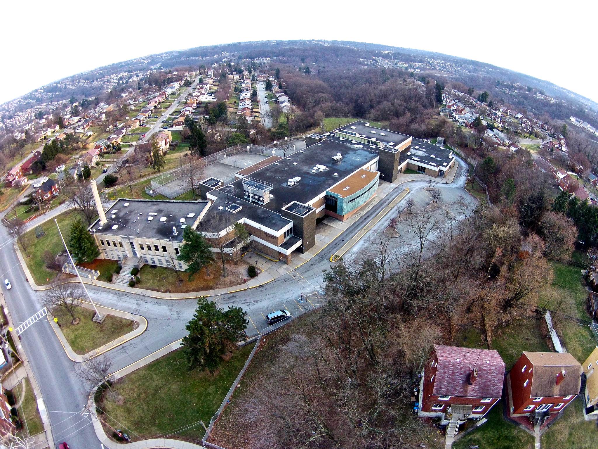
Brookline Elementary School (1909-present).
Originally built in 1909, the school was expanded in 1911 and 1929.

St. Pius X Church (1954-present). St.
Pius X Elementary School (1955-1996); Brookline Regional Catholic
School (1996-2014);
Saint John Bosco Academy (2014-present).

St. Mark's Evangelical Lutheran Church
(1906-present). The church was built in 1929 and the annex added in 1964.
The original St. Mark's Church building was located along Brookline Boulevard
(Bodkin Street) from 1908 to 1929.

Our Lady of Loreto Church and School
(1959-present). Our Lady of Loreto Elementary School (1962-2004).

West Liberty Elementary School
(1939-present). This is the third location of West Liberty School. The original
schoolhouse
was built in the 1860s at West Liberty Avenue and Cape May Avenue. In 1898, a new
school was built on Pioneer Avenue
where the Seton Center stands today. The present-day school building
was constructed in 1939 and enlarged in 1959.
Brookline's West Liberty School was decommissioned in 1979. After renovations,
it was reopened in 2001.

Pioneer Education Center
(1958-present). This first-class institution serves children with multiple and
medical disablilties.

South Brook Middle School, the newest school
in Brookline, opened in 2001. It stands next to the Pioneer Education
Center.
Carmalt Elementary School
(1937-present). The building was enlarged in 1973. The school is actually located
in Overbrook,
just across the border with Brookline. It has, however, served Brookline students
from Ward 32 since it's inception.

The Elizabeth-Seton Center
(1985-present). This is the former sight of West Liberty Elementary School (1898-1939)
and
Elizabeth-Seton High School (1941-1979). The Seton Center offers Adult Day-Care
Services and special programs for
Seniors. There are also Infant/Toddler, Pre-School and School-Age services
offered, along with a School of Music.

The Brookline Assembly Of God Pentecostal Church
was formerly the Brookline Methodist Church. The original
Methodist Church was built along Wedgemere Avenue bordering the alleyway, where the
small dormitory
stands today. The larger church building along the boulevard was constructed in the
1920s.
The Liberty
Tunnels
The Liberty Tunnels
opened to traffic in January 1924. The 5889 foot (just over one mile) twin tubes
cut through Mount Washington and provided quick access for South Hills residents
to downtown Pittsburgh. At the time they were the longest automobile tunnels in
the country and considered an engineering marvel. As a result, the Brookline
community saw exponential growth in both residential development and property
valuations.
The tunnels were the "Gateway to Suburbia"
and have continued to serve South Hills residents for nearly a century. The
modernized southern traffic interchange, which handles over 140,000 cars daily,
opened in November 1999. It greatly reduced traffic congestion at this busy
intersection. For a detailed history of the Liberty Tunnels, click here.

The southern portals of the Liberty Tunnels
and the Liberty Tunnels Interchange.

Looking downhill from Southcrest and Linda
Drive at the Liberty Tunnels southern portals in the distance.
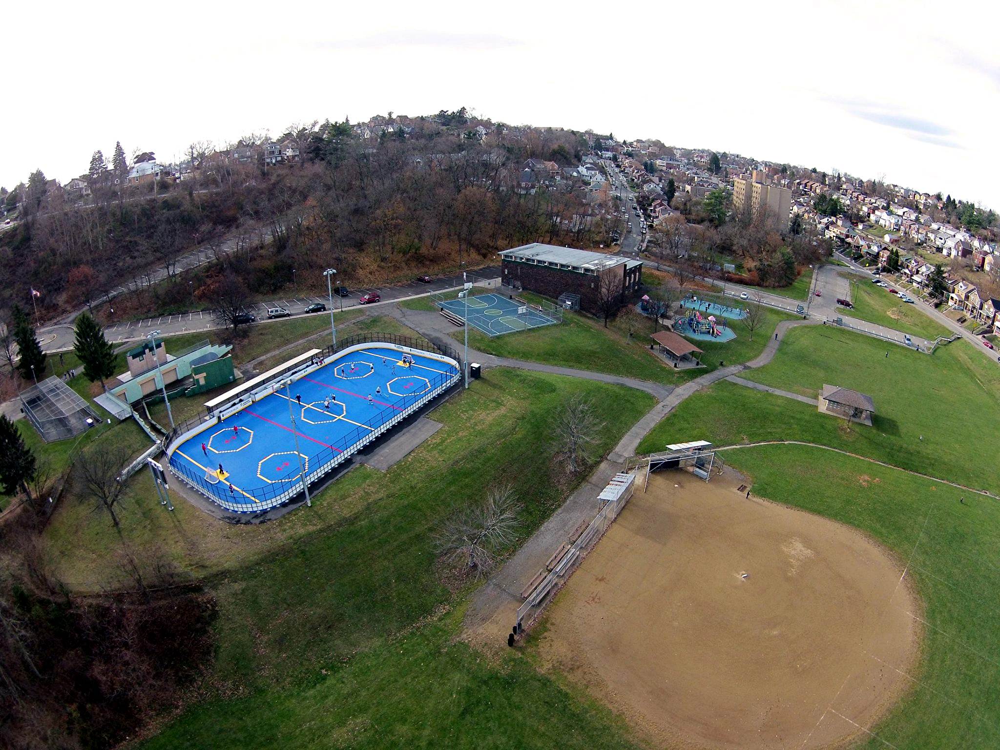
Joseph F. Moore
Park
Moore Park opened on August 9,
1940 and is named after Professor Joseph F. Moore, an influential
Brookline businessman and former-principal of Brookline Elementary
School. The ten-acre park and adjoining greenway were once part of the
vast 500-acre estate of Elizabeth Paul.
The park was built by the Federal
Works Project Administration. Moore Park was the first formal public
recreation facility in Brookline and has been an important community
asset for over seventy years. The swimming pool has provided welcome
relief from the summer heat to generations of Brookliners. For some
history on Brookline's Moore Park, click here.


Brookline Memorial
Community Center Park
Brookline Memorial Park was dedicated
on June 29, 1947. The developed land was once the sight of the twenty-acre
Anderson Farm, which dated back to 1874. In the late-1970s, the adjacent
forty-acre greenway was designated as an extension of the park.
Over the
years, the landscape and features of the property have gone through some
dramatic changes. For a detailed history on the evolution of Brookline
Memorial Park, click here.


A Short, But Sweet,
Drone Video
Spread your wings and
take a two minute flight above Brookline.

* Photos and video courtesy
of Matt Lackner * |