|
Three pictures that show the condition
of Brookline Boulevard near the junction with West Liberty Avenue in April
1909. This is the hilly stretch of the boulevard between Pioneer Avenue and
West Liberty, now Bodkin Street. The spring mud made this part of the boulevard
nearly impassable. The pictures show: Residents of outlying wards of Pittsburgh, harassed by delays and expenses incurred through deep mud on unpaved streets, will probably resort to unusual means to secure desired improvements. By the Act of 1895, if owners of abutting property refuse to petition for paving, councils by two-thirds vote may order the work done, and the costs assessed. Deep mud and increasing traffic, incident to the opening of spring, have aroused members of several communities to a high pitch of indignation. Short unpaved stretches of road are said to be retarding the natural development of extensive sections. Wagons are stalled, horses injured and transfer companies have increased rate because of difficulties attending hauling. Residents of Brookline are up in arms, because streets forming the connecting link of the former borough with the city include a short stretch of about 400 yards that is practically impassable. General inconvenience occasioned by the miring of several vehicles yesterday on the unpaved portion of Brookline Boulevard, adjoining West Liberty Avenue, brought indignation to a focus. Brookine, in consequence, will probably be the first to try to have paving done at the initiative of councils. The matter will be among the first brought to the attention of the new city fathers following their taking office tomorrow. It is hoped Charles N. Isler, select councilman elect and James N. Burke and David Bisset, the representatives of the Nineteenth Ward in the common branch, will become interested in the project and push it to a successful conclusion. Many communities, particularly in the more recently annexed sections of the city, will await the result of the attempt with interest. Similar action is contemplated in several instances where it is felt property-owners along streets needing paving cannot be arounsed to their duty. * Image and text copied from the Pittsburgh Daily Post - April 4, 1909 * Click on images for larger pictures.
This is the corner of Brookline Boulevard and West Liberty Avenue on August 24, 1909. Work has begun on the paving of the lower portion of the boulevard (what is now Bodkin Street). The sewer and water lines were being installed and the street paved in Belgian block. Only four months prior, on April 4, the Pittsburgh Daily Post ran photos of the poor condition of the road during the spring mud.
From 1909 until 1935, Bodkin Street was part of Brookline Boulevard, stretching from Pioneer Avenue to West Liberty Avenue. The trolley right-of-way that looped from West Liberty up the hill to Brookline Boulevard was an unpaved path and not used for vehicular traffic until the Boulevard was realigned in 1935. As for vehicular traffic, it looks like the horse and wagon was the main mode of transport back in these early days of the Brookline community.
Here is another photo from August 24, 1909, heading up Brookline Boulevard (now Bodkin Street) towards Pioneer Avenue at the top of the hill. It is interesting to see the Belgian blocks that will make up the roadway and curbs in their original state, the way they often arrived from the local quarry.
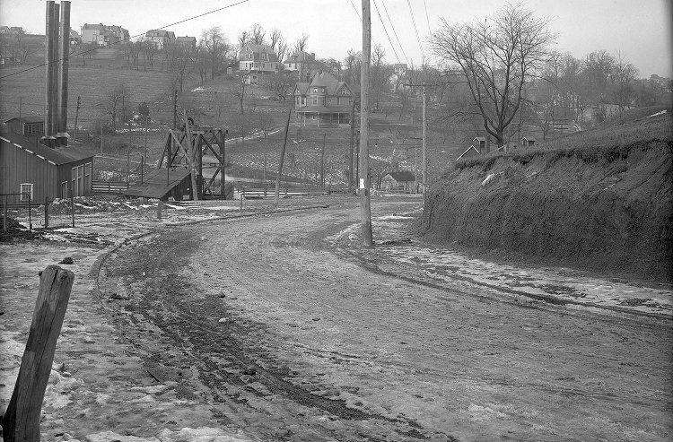
This photo is from October 1, 1909, looking from the curve at the lower end of Brookline Boulevard (now Bodkin Street) across West Liberty Avenue. The path in the background is Wenzel Avenue. The home on the far hillside belonged to the Kerr family, who owned a blacksmith shop at the corner of Wenzel and West Liberty. The field in front of the Kerr home is the site of the present-day McDonald's Restaurant.
This photo is from October 1, 1909, looking up Brookline Boulevard (now Bodkin Street) towards the intersection with Plainview Avenue on the left and Pioneer Avenue at the top of the hill. The original St. Mark Church stands on the hillside to the left. Built in 1907, the church was one of the original structures on this part of Brookline Boulevard and served the Lutheran congregation until 1928.
This photo is from October 1, 1909, looking across the valley from Brookline Boulevard (now Bodkin Street) towards Dormont (left) and Beechview (right) on the opposite hill in the background. The path up the hill is Wenzel Avenue. The path in the left center of the photo is the trolley right-of-way that leads from West Liberty up to Brookline Boulevard.
This photo is from December, 1909, looking up Brookline Boulevard (now Bodkin Street) from the intersection with Plainview Avenue towards Pioneer Avenue at the top of the hill. The Belgian block roadway has been completed, with sand covering the bricks to fill in the gaps.
This photo is from January, 1910. Slushy snow blankets the recently completed lower end of Brookline Boulevard, known then as The Boulevard Angle, or the Brookline Junction.
This final photo, taken in 1913 from Wenzel Avenue in Beechview, shows the lower end of Brookline Boulevard, from West Liberty Avenue to the intersection with Pioneer Avenue. The Belgian block roadway has been in use for slightly over three years, and would continue to be a part of Brookline Boulevard for the next twenty-two years. After the boulevard was re-routed in 1935, the block roadway remained in use for another seventy years under it's new designation as Bodkin Street. |