|

The Brookline Boulevard Commercial District
in 1936, looking west from Chelton Avenue and Veteran's Memorial Park.
Brookline Boulevard has been the commercial
and cultural center of the Community of Brookline since the early days of the
20th Century. It's roots date back much further, to the 1830s, when Pittsburghers
first began their slow migration into the southern hills.
The following is a short history of
Brookline Boulevard, which runs east-to-west through the heart of the neighborhood.
For generations of Brookliners, the boulevard has been a place that has enriched
their lives with it's unique character and charm.
History
of Brookline Boulevard
♦ Links To Photos Past And Present ♦
Brookline Boulevard, looking
northwest from near Glenarm Avenue towards Pioneer Avenue.
For more birds-eye views of the boulevard, visit Brookline As Seen From Above.
a fine collection of aerial images by Matt Lackner in December 2014.

Early South Hills
Roadways
From the first recorded colonial surveys, Brookline was part of Lower St. Clair Township, an area locally
referred to as Oak Hill, and later West Liberty. The wooded, rolling hills
were sparsely populated with individual farms.
It is hard to determine when exactly
the roadway that would one day become Brookline Boulevard was laid out. Pioneer
Avenue, which intersects the boulevard near it's western end, was established in
1797.
Pioneer was originally known as the
Pittsburgh to Washington State Road, and later referred to as the Coal Hill
and St. Clair Turnpike Road. A roadway of major importance until the 1840s,
in the latter part of the century it was renamed Lang Avenue.

The intersection of West Liberty Avenue and
Wenzel Avenue, shown in 1913. These were two of the earliest pioneer roads.
This photo was taken from the western end of Brookline Boulevard, a location known
as the Brookline Junction.
Wenzel Avenue was first laid out in 1832,
following a hilly path from present-day Greentree Road to Brookline Boulevard at
Pioneer. West Liberty Avenue followed in 1839, and was originally called Plummer's
Run, as it followed the course of Plummer's Run Creek down the valley to Saw Mill
Run. The future path of Brookline Boulevard most likely emerged around that time as a
dirt lane connecting the farms in this section of Lower St. Clair and
Baldwin.
In 1876, the Borough of West Liberty
was officially incorporated. It consisted of the present-day Brookline and
Beechview communities. Below ground, mining operations became the main
enterprise in the area. Above ground, the landscape was still dotted with farm
fields interspersed with large tracts of lush woodland. The 1880 census lists
the Borough's population as 865, with a large number settled along West Liberty
Avenue and Saw Mill Run.
Hunter Avenue and
Knowlson Avenue
Maps from the turn-of-the-century, during
the West Liberty Borough days, identify what is now Brookline Boulevard as Hunter
Avenue (Bodkin) and Knowlson Avenue. Hunter Avenue ran from West Liberty Avenue
to Lang Avenue (Pioneer), then merged into Knowlson Avenue, which ran along the
boulevard's present course to the borough border at Oak Street
(Whited).

A 1905 map showing the path of Brookline
Boulevard, then consisting of Hunter Avenue and Knowlson Avenue,
then part of West Liberty Borough. The roadway extended from
West Liberty Avenue to Whited Street.
Knowlson Avenue led to three connecting
roadways. They were Hughey Road (Edgebrook), Oak Street and Fairhaven Avenue
(approximate path of Merrick, Breining and Glenbury). These roads in turn led to
the Pittsburgh and Castle Shannon Railroad stations along Saw Mill Run.
On the entire mile-long length of Knowlson there
were just two additional pathways, both leading to the family homesteads in the vast
Knowlson Farm. The quaint, comfortable atmosphere of this rural American landscape
would soon change.
Small Clusters
Of Homes Along Oak Hill
In the late-1800s, the majority of
the population within the present-day borders of Brookline lived along
the West Liberty Avenue and Saw Mill Run Corridor. Along West Liberty Avenue,
just south of Warrington Avenue at the base of the hillside, were the Sauter
Place and Lewis/Garrigan plans.
Going east, from West Liberty along
the Saw Mill Run corridor to the Borough border, were the established Boggs
Place and Zimmerman Park plans. Both were positioned along the West Side Belt
railroad line.

An 1896 map showing the small town
of Reflectorville, located at the bottom of
Edgebrook Avenue, then known as Hughey Road, or the Township Road.
From Hughey Road to Oak Street was the
small hamlet of Reflectorville, established in 1890. This land was formerly
part of Baldwin Township, and later Overbrook Borough. The homes were part of
the Bailey and Moon plans. The settlement was developed by Thomas Bailey and David
Moon, president and treasurer of Pittsburgh's Bailey Reflector Company.
These small housing tracts were populated
largely by the families of miners who worked in the Oak Mine and railroad employees. Aside from these clusters of homes
along the Oak Hill valleys, there was no other formal housing development
happening in this part of West Liberty Borough as the 19th Century drew
to a close.
West Liberty
Improvement Company
The transformation of Oak Hill from rural
farmland to urban neighborhood began in the early-1900s. The first housing plans
to appear in the newspapers and on plot maps were the Fleming Place
and Hughey Farms Plan, in 1902.
Located between Lang and West Liberty Avenue, these homes were advertised as being
in the Mount Lebanon District.

A 1905 map showing the Paul Place
Plan.
Further to the north, along Lang Avenue,
another tract of homes was being developed by the Paul Land Company. This plan
included streets like Oakwood Avenue (Capital), High Street (Plainview),
Terrace Street (Woodward), Hamline Avenue (Stetson), Orchard Avenue (Dunster),
Centre Avenue (Mayville), Siebert Avenue (Fernhill) and Stang Avenue
(LaMarido).
On March 12, 1905, the West Liberty
Improvement Company acquired 500 acres of borough land through the sale of ten farms in the eastern part of the borough and, in cooperation with the
other development firms, began drawing up blueprints that were the Birth of
Brookline.

A Freehold Real Estate advertisement
from the Post-Gazette announcing the new "Boulevard at Brookline."
Engineers designed Brookline as a
stand-alone suburban municipality, free of the noise and smog of the city,
with Brookline Boulevard as the main street. The same was being done by the
Beechwood Improvement Company in the adjoining Beechview section of West
Liberty, with Broadway Avenue as it's central roadway.
Within months of the farm sale, newspapers
began running a series of real estate advertisements touting the emerging suburb. The length of roadway
consisting of Hunter and Knowlson Avenue were combined to form one broad street,
the Boulevard at Brookline, around which the new South Hills community would
grow.

A 1905 Freehold illustration of
Brookline's grand new boulevard.
While the West Liberty Improvement
Company worked quickly to build the infrastructure of the community, the
Freehold Real Estate Company set up an office at the corner of Brookline
Boulevard, Chelsea (Chelton) and Queensboro Avenues. From this crossroads
location, Freehold agents orchestrated the early growth and development of
the community.
Pittsburgh Railways
39-Brookline
Also in 1905, the Pittsburgh Railways
Company installed the original single-track streetcar line connecting Brookline
to the City of Pittsburgh via the recently-constructed Mount Washington
Transit Tunnel. The new branch route was given the designation 39-Brookline.

The Brookline Junction, shown here in 1915,
during the early stages of the West Liberty Avenue reconstruction. The first
electrified streetcar route in the South Hills was installed in 1902
and followed the single-track line to Mount Lebanon.
The 39-Brookline followed the double-track to the left and on to the
right-of-way that led to Brookline Boulevard.
The route ran along West Liberty
Avenue to the Brookline Junction. It followed a looping right-of-way to
the intersection of Brookline Boulevard and Pioneer Avenue, then followed
the length of the boulevard to Breining Street. From there it proceeded
into Overbrook and on to a junction with the Charleroi line, along Saw Mill
Run, for the return trip to town.
In 1910, the Brookline route was altered.
Instead of a continuous one-way loop from downtown Pittsburgh and back, the line,
which had been double-tracked along the boulevard, beginning at West Liberty
Avenue through to Edgebeook, was extended to a looping turnaround constructed
astride the 1400 block of the emerging housing development called East
Brookline.

A Pittsburgh Railways Jones Car, first
introduced in the 1920s, marked for the 39-Brookline route stands at the
South Hills Junction in 1948. The original trolleys used in Brookline were four-wheelers known as box cars.
Streetcars now traveled in both directions
along Brookline Boulevard. For the next fifty-six years, the 39-Brookline
provided the growing neighborhood with reliable public transportation. In the
early years, before automobiles became the standard mode of travel, the streetcar
was the most common way to get from here to there within the city of
Pittsburgh.
Slow But Steady
Growth Of The Community
On January 4, 1908, West Liberty Borough
was annexed into the City of Pittsburgh. Municipal dollars now began to flow
into the fledgling community of Brookline. Along with improvements in the
streetcar line, the boulevard road surface was paved for the first
time using a mix of bricks and belgian block.

Brookline Boulevard in early 1909,
looking from Flatbush Avenue towards Castlegate Avenue. The first building
on the left is Dooley's Meat Market, constructed in 1907. The firehouse
behind it is still under construction.

Brookline Boulevard in 1910 at the
corner of Chelton Avenue. The Freehold Real Estate office stands
on the corner island where present-day Triangle Park and the Veteran's
Memorial reside.
The streetcar line ran down the
center of the roadway. On each side of the right-of-way was one lane
for horse-drawn wagon and vehicular traffic, and another for parallel
parking.
Along the broad avenue were a mix of
residential homes and commercial establishments. From Pioneer Avenue to
the city line at Edgebrook Avenue, new houses appeared on the northern side.
Across the street, larger two and three-story structures, with first-floor
merchant space and apartments above, were constructed across the street.

To see a collection of Freehold
Real Estate advertisements from 1905-1907, click here.
One of the first business establishments
was Dooley's Meat Market, built in 1907 and located at 704 Brookline Boulevard.
The original Brookline Methodist Church, at the corner of Wedgemere Avenue,
and the two-story stone house at the corner of Pioneer which served as the office
of Brookline's first physician, Dr. C.C. Lang, were also erected that
same year.
Maps published in early-1910 showed
six businesses and eight homes standing between Pioneer Avenue and the city
line. This count included four three-story structures and the large estate
home of David Hunter, located on a large lot at the corner of Pioneer, across
the boulevard from the Lang residence.
Also shown are the Methodist Church and
the Pittsburgh Bureau of Fire Engine House #57 at the corner of Castlegate Avenue. Construction
of the historic firehouse began in 1910 and the building was officially dedicated
on June 23, 1911.

Brookline's Engine House #57, shown
here in 1920.
In 1912, another iconic Brookline
Boulevard church was constructed. The Brookline Boulevard United Presbyterians
built their Stone Chapel at the corner of Queensboro Avenue. Like the
Methodist Church, the chapel was a much smaller version of the present-day
church. Both churches were enlarged to their present-day grandeur in the
1920s.
------------------------------------------------------------
|
In January 11, 1914, the Board of Trade,
formed in 1907, installed new officers. H.H. Wolfe succeeded E.H. Melvin as
president. H.F. Ruoff became vice-president; H.L. Angloch, second vice-president;
J.H. Dumbell, secretary, and George Hughey, treasurer.
The new president appointed the following
committees; Transportation - H. Ruoff, chairman; A.J. Shirring, J.P. Myron,
R.S. Flinn, R.A. Armstrong and Edward Ebrenz. Health and sanitation - Dr. Steffy,
chairman; Dr. O. Hogen, Dr. Marks, M. Rihn, F.O. Nixon and George Seska. Civic
improvement - P.S. Space, chairman; J.T. Bealor, H.L. Angloch, George Turnbaugh,
Edward S. Cook and C.E. Keck. Legislation - J.J. Sullivan, chairman; J.J. Lippencott,
Joseph Hammerle, E.G. Fink, J.H. Evans and G.W. Wilson. Municipal and county
affairs - Dr. R.A. Hutchinson, chairman; W.R. Cole, H.B. Cox, J.H. Weigman,
Thomas Musgrove and R.D. Cree. Streets, sewers and lights - George Hughey,
chairman; J.H. Mullholland, J.M. Knight, A.W. McCance, J.N. Sullebarger and
C.D Cooley. Education - Joseph F. Moore, chairman; W.G. Gans, C.E. Fulton,
Joseph G. Dooley, W.S. Foster and T.R. Williamson. |
------------------------------------------------------------
By early-1916 the number of homes and
businesses along Brookline Boulevard had grown from seventeen to thirty-two. Many
of the commercial establishments were grocery and meat markets. While housing
development throughout the community continued at a brisk pace, this steady
growth of the Commercial District proceeded into the following decade.
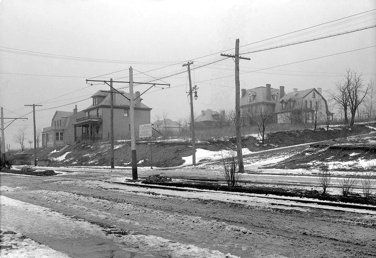
Brookline Boulevard, at the corner of
Flatbush Avenue, in March 1916. Also visible are homes along Bellaire
Avenue.
 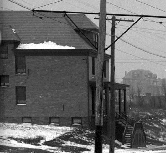
A view of Brookline Boulevard, looking towards
Stebbins Avenue (left), and a new home along the residential side in 1916.
Visible in the left photo is the United Presbyterian Church's
original Stone Chapel at Queensboro and Chelton Avenues.

The Brookline News Agency and the office of
Caterer C.M. Reeves, shown in 1916, located at 806 Brookline
Boulevard.
This building, across from the Flatbush intersection, is the present-day location
of Gordon's Lounge.
The Liberty Tunnels
Bring Prosperity
One of the biggest contributors to
growth and prosperity in Brookline came in 1924, with the opening of
the Liberty Tunnels. The 5889 foot Twin Tubes, as they were commonly called, were
an engineering marvel, bored through Mount Washington, that connected the
South Hills communities with downtown Pittsburgh.

The Roaring Twenties were an era of
sustained economic prosperity following the Great War. It was also the
age of Henry Ford's Model T, and many families now owned an automobile. Travel
time to and from the Golden Triangle was slashed to a matter of minutes.
Beginning in 1921, Brookline Boulevard
rapidly took on a new look. The entire length of the roadway was covered in
paving bricks, from Pioneer Avenue through to Breining Street. Real Estate
advertisements, like the one shown above that appeared on June 5, 1921 in the
Sunday Pittsburgh Gazette Times, touted both the Twin Traffic Tunnels and
boulevard improvements.
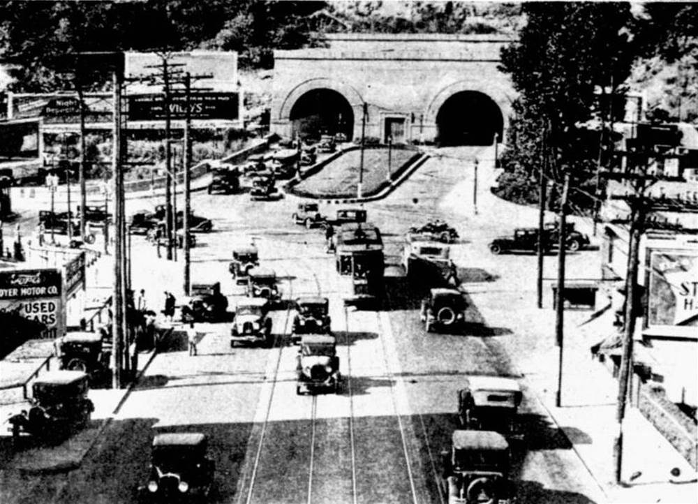
The southern portals of the Liberty Tunnels,
at the junction of West Liberty Avenue and Saw Mill Run Boulevard, in 1930.
Opened in 1924, the Twin Tubes, like the streetcar service that began in 1904, were
a major transportation
improvement that brought exponential growth and investment to the South Hills
communities.
As a direct result of the tunnel project,
real estate sales and housing development in the southern neighborhoods entered a
boom phase as the population swelled. This accelerated upon completion of the
tunnels.
By 1925, the population of Brookline had
more than doubled and property values skyrocketed. Three farms in Brookline that
were appraised at $68,000 in 1920 saw their property valuation increase to $1.3
million. Individual housing and retail space also saw considerable
gains.
 
Brookline Boulevard in 1924, showing street
conditions near Queensboro Avenue (left) and Castlegate Avenue.
Construction of housing and new business
establishments took place all along the boulevard commercial district. Providing the
financing for much of this activity was the Brookline Savings and Trust Company, which opened its doors in 1926. Located at 820
Brookline Boulevard, the financial institution was instrumental in the further
development of the community.
By the end of the decade, there were
nearly 100 buildings lining the thoroughfare from Pioneer Avenue to Edgebrook.
The northern side of the street was a nearly continuous line of homes. The
southern side lined with a variety of businesses, including two movie theatres,
most with multiple apartments or merchant living quarters on the upper
floors.
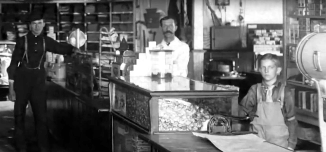
The counter at the Kroger Grocery store at
944 Brookline Boulevard in 1925.
The Upper And Lower
End Of The Boulevard
The east-west main street through the
Commercial District was flanked on either side by the upper and lower sections
of Brookline Boulevard. The upper stretch, or the western end, ran from Pioneer
Avenue to West Liberty Avenue and the Brookline Junction.
One of the original boulevard churches
was built along the upper section at 403 Brookline Boulevard, just west of Pioneer
Avenue at the Shawhan Avenue intersection. The St. Marks Lutheran chapel opened on
September 20, 1908. Twenty years later, the Mission moved to a much larger
church constructed at the corner of the boulevard and Glenarm Avenue.
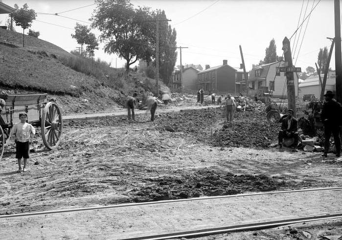 
The corner of West Liberty Avenue and
Brookline Boulevard during street paving in 1909 (left), and a 1913 view of
the lower end of the boulevard. St. Marks Church, opened in 1908, can be seen
to the left of the roadway.
In October 1909, this two-lane hilly
portion of the boulevard, formerly known as Hunter Avenue and presently
called Bodkin Street, was paved in belgian block. As the boundary of the
Fleming Place and Hughey Farms Plan, homes were built on either side of the
roadway. It was one of the main community gateways and saw increasingly heavy
vehicular traffic.
The lower section of the boulevard,
or the eastern end, from Edgebrook Avenue to Jacob Street, evolved in the mid-1910s
during the development of the East Brookline housing plans. This stretch of
the roadway followed the path of the streetcar line into Overbrook Borough.

A 1951 view of the lower end of Brookline
Boulevard, along the 1400 block, looking west towards Breining Street.
Beyond Breining Street, it was extended
as a two-lane residential roadway along the northern side of the Fairhaven
Valley to Jacob Street, where the boulevard came to an end. A left turn at Jacob
Street led to Whited Street and on to the Saw Mill Run corridor.
By the end of the 1920s, this lower
section of the boulevard was lined with new residential housing. In 1930,
Overbrook was annexed into the city, and the entire lower section of the
boulevard was incorporated into the boundaries of the Brookline
community.
Weathering The Great
Depression Years
In 1929, Brookline's population had
swelled to nearly 14,000. On school days, the boulevard was deluged with children
walking to or from class. Overcrowding at Brookline and West
Liberty Elementary led to the final major community improvement of the Roaring
Twenties.
In September 1929, Brookline Elementary
School celebrated the grand opening of their newly-built education wing,
which nearly doubled the student capacity. It seemed as though the good times
and continual prosperity would never end.
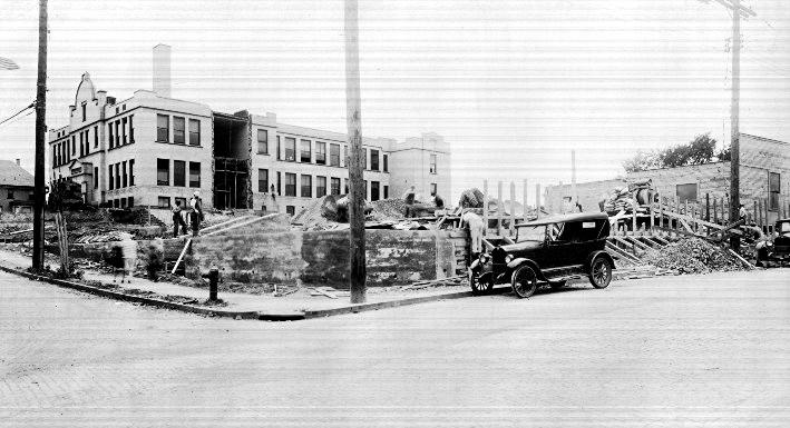
A new wing is added to Brookline Elementary
School, located at the corner of Pioneer and Woodbourne Avenue, in 1929.
On "Black Tuesday," October 29, 1929,
the Wall Street Panic struck and sent the country spiraling into the Great
Depression. The community of Brookline joined the nation in struggling with
the difficult economic times that followed.
One of the first casualties was the
housing market. The once thriving enterprise suffered a series of foreclosures
and defaults on loans. New construction and sales came to a halt. Merchants
also felt the sting of the monetary crisis and some went out of business.
 
Looking southeast along the streetcar
rails that ran down the center of Brookline Boulevard from near Pioneer Avenue (left),
and a 39-Brookline Jones Car approaches the Stebbins Avenue Car Stop in 1933. The
second building from the
right is the original Brookline Savings and Trust building, with it's stately,
pillared concrete facade.
With such a large industrial base, the
City of Pittsburgh faired better than some other metropolitan areas, but times
were still tough. Boulevard churches, with the help of local merchants and
farmers, sponsored soup kitchens and clothing drives to help the needy.
The Brookline Savings and Trust Company
also came to the aid of it's customers by offering innovative financial services
and consumer outreach programs.
As a community, Brookliners came
together and endured the hardships of these lean years. The valuable skills
learned and the social bonds formed in this difficult time would bear
fruit once again in the early-1940s, during the frugal rationing years
of World War II.
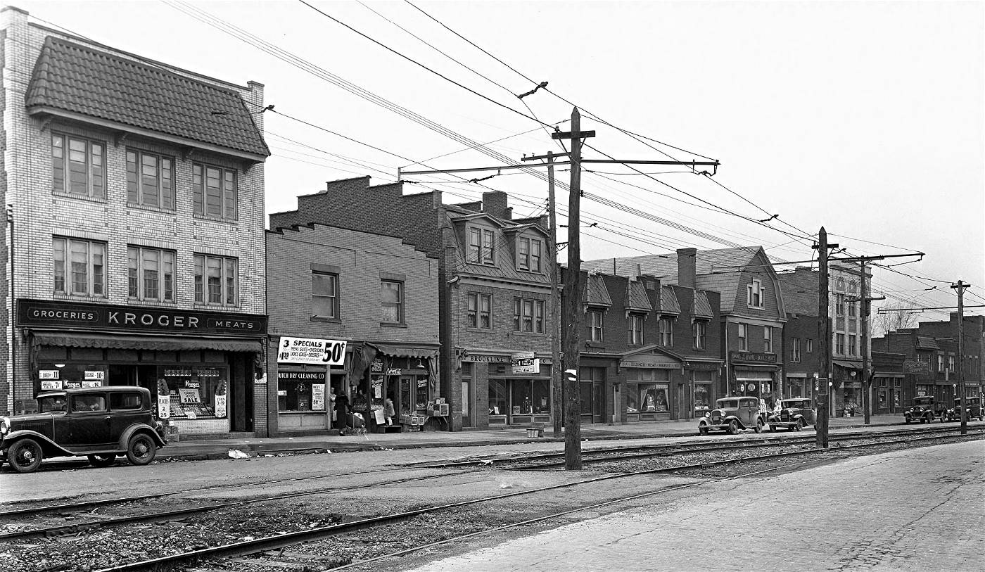 
Two views of the Brookline Boulevard Commercial
District in 1933, from near Glenarm Avenue (left) and Flatbush Avenue.
Brookline Boulevard
Triangle Park
Despite the struggling economy of
the Depression Years, the Brookline Joint Civic Committee was busy working
on several initiatives to modernize and improve the community. One such
project was to establish a permanent Veteran's Memorial to honor Brookline soldiers
who fought in the Great War.
In 1932, as a result of the decline
in home sales, the Freehold Real Estate Company closed their Brookline Boulevard
office. The firm that did so much to further the development of the community
retreated to their downtown office and put their landmark parcel of property,
the "Boulevard Triangle," on the market.

A 1916 map showing the Boulevard Triangle.
Chelton Avenue is still listed as Chelsea.
Like many Brookline streets, old plot maps still show the former Borough names.
Interestingly, when Brookline was formed in 1905, Chelsea Avenue and the
Boulevard Triangle were both located across the official border of
West Liberty Borough in neighboring Baldwin Township.
The uniquely situated lot was purchased
by James McGaffin, a prominent local businessman and a member of the Civic
Committee. On April 18, 1934, McGaffin sold the triangle to the city Department
of Parks for $5750 with the intent of establishing a permanent memorial.
The land was officially designated
in the municipal ledger as Brookline Boulevard Triangle Park. Shortly
afterwards, the original cannon and white marble memorial were mounted and
dedicated by members of Brookline's American Legion Post #540.

The original cannon at Brookline's Veteran's
Memorial and members of American Legion Post #540 on October 13, 1942.
That first cannon, a 1906 47mm
artillery piece, stood in the park for eight years, until another global
conflict called it back into service. In October 1942, Brookline's
cannon was donated to Jones and Laughlin Steel to be melted down during
a World War II scrap metal drive.
After the war, the park received a new
cannon, this time a 1917 155mm Schneider howitzer. Made in France, the model
was the standard field artillery piece of the American Expeditionary Force.
In June 1946, the Triangle Park was re-dedicated to veterans of both
World Wars.
Finally, in 1992, the aging marble
memorial was replaced with a polished pink granite and bronze memorial
honoring soldiers of all conflicts. The cannon itself, a reminder
of the Great War, has been one of the most iconic features along
Brookline Boulevard for the past eighty years.
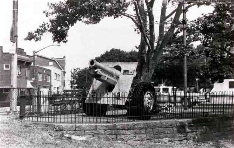
Veteran's Memorial Park and the Brookline
Cannon in the 1970s. The original white marble monument is partially visible.
Modernization Of Brookline
Boulevard
One of the major goals of the Joint
Civic Committee was the modernization of Brookline Boulevard as a whole. The
community had outgrown the antiquated road conditions that existed at the
time. Increasing vehicular, rail and pedestrian traffic had created serious
safety concerns. The time had come for the boulevard to undergo it's first
extreme makeover.
Proposals called for a wide range
of infrastructure improvements, repaving the entire boulevard to include
four traffic lanes from Pioneer to Edgebrook, and rerouting the western
end of the road onto the trolley right-of-way to create a continuous
four-lane thoroughfare all the way to West Liberty Avenue. The project
sat idle while authorities lobbied for funding.

A 1916 map showing the former alignment
of Brookline Boulevard from West Liberty Avenue to Pioneer Avenue
and the Pittsburgh Railways 39-Brookline streetcar right-of-way looping
through the Fleming Place Plan.
In 1935, as the Nation's economy
began to emerge from the Depression Era, federal dollars began to flow
through New Deal programs like the Works Project Administration. That
fall, work finally began on a major reconstruction of Brookline
Boulevard.
The entire roadway was resurfaced
in red and gray paving bricks, including the trolley right of way along the
center. The tracks remained, and streetcars now shared the middle lanes
with an ever-growing number of autombiles and trucks. Sewers, sidewalks,
lighting and other utilities were replaced, along with other upgrades.
The intersection of Pioneer Avenue was
completely rebuilt. Knowing that the home located on the corner of Pioneer and
Brookline Boulevard, the former office of Dr. Lang, stood in the path of the
expanded intersection, homeowner J.P. Meyers made the decision that rather than
demolish the home, he would move it.

The home that once stood on the corner of Pioneer
Avenue and Brookline Boulevard, shown here in 1909, was moved
in 1932 to an adjacent lot on Berkshire Avenue in preparation for the 1935 reconstruction
project.
In 1932, anticipating the upcoming
reconstruction Myers purchased the small frame house at the corner of Pioneer
and Berkshire Avenue and had it razed. Contractors then moved his home across
the alleyway (Trelona) and placed it on the vacant lot.
Myers then constructed a small gas and
service station on the truncated lot where his house once stood. The old home
and the gas station building, in later years a pizza shop, stood until 1999,
when both were demolished during construction of the present-day CVS
Pharmacy.
The biggest change to Brookline
Boulevard during this reconstruction project was the creation of the
boulevard loop. The roadway was rerouted onto the Pittsburgh Railways
right-of-way, which looped through the Fleming Place properties to
the Brookline Junction.
 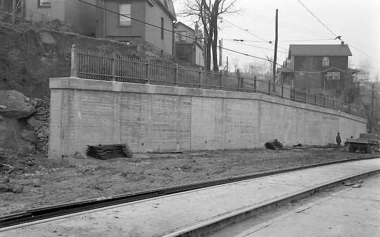
The corner of Brookline Boulevard and
Pioneer Avenue in 1935 (left) during reconstruction. In the distance is the estate
of David Hunter, one of West Liberty's early landowners.
It was razed in the 1940s to build an apartment complex.
The photo to the right shows the retaining wall that was built below the
Jillson and Shawhan Avenue intersection.

When completed, the new Brookline
Boulevard Loop was a fine four-lane gateway into the community.
The path was widened to accomodate
four lanes of traffic and the surface was paved in belgian block. The
streetcar tracks were placed in the center along the length of the street
and connected with the Mount Lebanon line at West Liberty Avenue.
New sidewalks and a decorative
steel guard rail were installed. Below the corner of Jillson and Shawhan
Avenues, both of which were cut off during construction, a small retaining
wall was built. Sixty years later that same wall would become the canvas
for a familiar community welcome sign, the Brookline Mural.
By the fall of 1936, when the project
ended, Brookline Boulevard had been transformed into a modern main street. The
stunning stunning results were a major improvement that helped bring growth and
prosperity to the boulevard and the community as a whole.
 
A beer delivery (left), and two shop owners
having a chat along the 500 block of Brookline Boulevard in 1936.

A view towards the Pioneer Avenue Car Stop
and loading platform in 1936. The home is along Bodkin Street.
It's Now Called
Bodkin Street
Another big change that occured
during the Boulevard Reconstruction Project of 1935/1936 was the creation
of a new street, in a manner of speaking.
The realignment of the Pioneer
Avenue intersection required the building of a large retaining wall
that cut off the former western length of the main street. The old
boulevard became a dead end that extended from the wall to the lower
end of the new boulevard at West Liberty Avenue.
A short flight of city steps were
built from Pioneer Avenue down to the existing street level to provide
stranded Bodkin Street residents with access to the trolley car
stop.
When Brookline Boulevard was rerouted
onto the new loop, the portion of the street that was cut off and no longer
part of the main drag, needed a new street designation. In July of 1935
City Council enacted a series of ordinances delineating the new footprint of
streets like Shawhan, Edgevale, and Kenilworth Avenues, all redesigned during
the project.
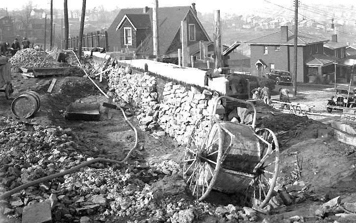
The retaining wall built during the
1935 reconstruction of Brookline Boulevard. The former section
of Brookline Boulevard now stood cut off to the right. It was now a
distinct street in need of a name.
One of those ordinances dealt with
this former length of Brookline Boulevard. On that day in July 1935, City
Council ordained that it would become part of Wenzell Avenue, as it was
long ago during the St. Clair Township days, and carry that name. In November
1936 City Council decided to give this roadway its own distinct name, and from
thence forth it has been designated as Bodkin Street on city
maps.
This was the fourth and final name change
for this vintage stretch of South Hills roadway, which was one of the earliest
on record. Originally it was a township road stretching from the state road
(Pioneer Avenue) all the way to Greentree Road. It was called Wenzell Avenue.
During the borough days, from 1876 to 1905 it was called Hunter Avenue. From
1905 to 1936 it was part of Brookline Boulevard and, finally, Bodkin
Street.
Other major achievements of the Joint
Civic Committee in the late-1930s were community advancements in education
and recreation. The increasing student population was served by the
construction of Carmalt (1937) and West Liberty (1939) Elementary Schools. The lack of a public recreation facility
ended with the creation of Moore Park, another Works Project Administration
contribution that opened in 1940.
The Proposed Eastern
Extension
Another of the Joint Civic Committee
initiatives pursued in the late-1930s that met with less success was the
construction of an Eastern Extension of
the boulevard, designed to link up with Saw Mill Run Boulevard.
The Brookline Boulevard Reconstruction
Project only covered the roadway from West Liberty Avenue to the Edgebrook Avenue
intersection. From that point on to Breining Street was still restricted to one
lane in each direction, with the trolley line running down the center. From
Breining to Jacob Street the road was further reduced to a narrow two-lane
residential drive.

Brookline Boulevard in 1951 looking east towards
the Breining Street intersection and the start of the two-lane residential
section of the roadway. Maps dating to 1916 show an alternate route that veared
to the right into the valley.
Advocates argued that the lower end of
the boulevard was never designed to be the main street, and the lack of a
continuous four-lane thoroughfare was prohibitive to the future growth of the
community. In addition to a number of safety concerns, the committee's proposal
was intended to "make the boulevard go somewhere."
The planned boulevard extension would
follow the course of the existing Pittsburgh Railways right-of-way through the
Fairhaven Valley. This path served as the original 39-Brookline trolley route
from 1905 to 1909.

The broad avenue would pass through the
Brookdale housing tract, scheduled to be constructed in the undeveloped wooded
section of the community, and meet Saw Mill Run Boulevard at a point near Overbrook
School. City plot maps dating back to 1916 actually identify this route as the
anticipated path of Brookline Boulevard.
Although the proposal came highly
recommended by local civic leaders, it did not have the endorsement of City Council
and the project was shelved. Although consigned to the drawing board, the
Eastern Extension issue remained in the news for the next three decades.

A 1951 editorial cartoon that appeared in the
Brookline Journal describing
the boulevard conditions to the east of Edgebrook Avenue.
Some adjustments were made in the mid-1950s
to address pedestrian and vehicle safety concerns, most notably the removal of the
metal white-striped utility poles that lined the boulevard from Edgebrook to Breining
Street. These poles, which supported the trolley line, were the cause of
several vehicle accidents.
Other concerns such as paving the road weren't
addressed until 1966, when the trolley right-of-way was paved from Edgebrook to
Breining, widening the road to four unobstructed lanes. From Breining on, the roadway
has never been altered.
By the 1970s, the once-popular concept
had faded from memory. The abandonment of the Brookdale plan, an expansion of
Brookline Memorial Park and the increasing traffic congestion along Saw Mill
Run ended any prospect of an Eastern Extension.

The lower section of Brookline Boulevard, near
the Roseville Street and Greencrest Drive intersection, shown here in 1982.
The Era Of Post-War
Prosperity
During the war years, the only change
to occur along the boulevard was the construction of the Carnegie Library
branch location at 730 Brookline Boulevard. Elsewhere, merchants and
residents throughout the community did their best to cope with the
restrictions of rationing and their concern about the hundreds of
local men and women serving overseas.

A 1947 aerial view of Brookline Boulevard,
at Castlegate Avenue, showing construction
of the Premier Photo Company and Kroger Grocery buildings.
When the Second World War came to a
conclusion, Brookline veterans returned home to a country that was
entering an era of unprecedented economic growth. The same was true, on
a smaller scale, right here in Brookline.
Industry was booming in Pittsburgh
and the working wage was on the rise. New home construction in the community
reached levels not seen since the 1920s. Brookline's large middle-class
population grew stronger as a result. There was plenty of money to spend, and
Brookline Boulevard became the place to spread it around.

Long-time merchant Morris Grumet
stands outside of his Grocery Market, constructed at 1160 Brookline
Boulevard in 1950.
The Brookline Journal
was a weekly newspaper that documented the life and times of the community
from 1931 to 1982. Editions from the early-1950s give keen insight the life
and times during these golden years.
1951 Review / Brookline Journal Collection ** 1952 Review / Brookline Journal Collection
This surge in retail sales led to
a corresponding spike in commercial construction. Along merchant sector,
the remaining vacant lots were soon the scene of new buildings.

DeBor
Funeral Home, at the corner
of Edgebrook Avenue, had its grand opening on the weekend of April 20-22, 1951.
The family-owned parlor is one of the longest-standing commercial establishments on
Brookline Boulevard.
The Premier Photo Shop building
(present-day Carnegie Library), the A&P Super Market (present-day Pitaland) and the Brookline Post
Office were all built in the
fifties. The Brookline Savings and Trust Company building was expanded and modernized, as
was Melman's Super Market. The United Presbyterian Church was enlarged for the third time.
New storefronts also appeared on the
residential side of the street. Many homeowners built ground-level
additions in the front of their property, creating additional merchant
space. The decade also saw three new buildings rise along the 1100 block,
including DeBor Funeral Home.

The Brookline Savings and Trust, at 818
Brookline Boulevard, in 1953. The successful financial institution played a major
role in the development of the community. It was purchased in
1969 and is presently a branch office of PNC Bank.
Beyond Edgebrook Avenue, on the
lower stretch of the boulevard, Grumet's Market and Brookline Fabric Company both built new
stores. The largest commercial development was the East Brookline Shopping
Center, located at the corner of Breining Street. It featured a Super Market,
laundramat, pharmacy and a beauty salon.
On the downside, the Boulevard
Theatre, which was opened
in 1937, closed it's doors in 1952. The building was bought by the Cedars
of Lebanon as a lodge. It was the second local theatre to shutter its doors.
The nearby Brookline Theatre ceased operation in 1945. The loss of these
vintage movie houses were the only negatives in this era of post-war
prosperity.

Johnson's Shoe Store was in operation
during the 1940s and 1950s.
Brookline Boulevard - An
Outdoor Shopping Mall
In many ways, Brookline Boulevard had
entered a Golden Age. By the end of the 1950s, there was practically nowhere
left in the Commercial District on which to build and expand.
The grand roadway truly had become the
centerpiece of the neighborhood, a vibrant, walkable outdoor shopping mall
packed with a wide variety of stores and attractions that catered to almost
every need of the local citizenry.

Brookline Boulevard in 1967, looking
east from near the intersection with Castlegate Avenue. The Commercial District
was a thriving market place with a wide variety of stores and attractions
to serve the community.
Along the main street were a number
of grocery and meat markets, toy stores, hardware stores, gift shops, doctor's
and dentist's offices, soda shops and pharmacies. There was a furniture store
and separate clothing outlets for men, women and children.
Among the storefronts were bakeries,
barber shops, appliance stores, repair shops, bowling alleys, pool halls,
restaurants, bars, tailors, dry cleaners, banquet halls, night clubs, gas
stations, realtors, a sporting goods store and much more.

Two trolley cars, one inbound and one outbound,
pass near Flatbush Avenue along Brookline Boulevard in 1965.
For travelers and commuters, the
39-Brookline streetcar could take you from one end of the boulevard to the
other, or reach out to all corners of the city of Pittsburgh.
By 1965 the population of Brookline
had swelled to a peak of nearly 22,000 residents, the majority of whom did
their shopping within minutes of home. The happy times of the 1950s and
early-1960s could be considered the 20th Century zenith of Brookline
Boulevard.

Pittsburgh Post-Gazette/Sun-Telegraph -
July 13, 1960.
Neighborhood Parade
Ground
On holidays and special occasions,
Brookline Boulevard has always served as the main location for parades and
community celebrations. For many years, the Independence Day Parade was one
of the most highly-anticipated events of the year.
In the earliest days of the community,
a procession of bands, dance troupes, horse-drawn wagons, vintage automobiles,
church groups and local dignitaries would make their way towards Pioneer
Avenue on the 4th of July.
 
The Independence Day Parade in 1954 (left)
and the Memorial Day Parade in 2012.
Afterwards, parade-goers would gather
along the boulevard. Fireworks displays were followed by an evening of
moving-pictures. Residents would sit on open ground along the high side of
the boulevard near Flatbush Avenue and the movies would be projected onto
bedsheets strung from poles on the commercial side.

Majorettes prepare for a War Bond Parade
in October 1942.
As the years progressed, the parade
route was extended to Brookline Elementary, where the community festival
and fireworks display was held on the school field. Later, these activities
were moved to Moore Park.
♦ 1:15 Minute Video of 1960s-era Memorial Day
Parade ♦
Jack Frank Films
The Independence Day parades came
to an end in the 1960s. They were just one of several held along Brookline
Boulevard over the years. The annual Memorial Day Parade began in 1934 and
has continued until the present-day. During World War II, parades were held
during the many War Bond Drives.

Pittsburgh Mayor Sophie Masloff walks
along with Charlie McLaughlin and
State Senator Mike Dawida during the Halloween Parade in 1992.
Other parades during the year are
the Chamber of Commerce Halloween Parade and the Brookline Little League
Parade. On occasion, special parades have been held, such as in 1965 when
a fundraiser was held for Brookline Park, and in 1976 for the Bicentennial
celebration.
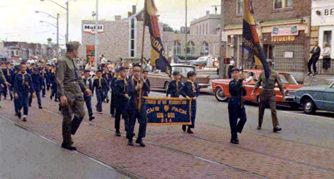 
Resurrection's Cub Scout Pack 106-601
passes Triangle Park on their way to Brookline Park during a 1965 fundraising
event (left), and ballplayers follow the stars and stripes during the annual Little
League parade in 1976.
Streetcar Service
Discontinued
For sixty-one long years, the primary
method of public transportation in the neighborhood was the 39-Brookline trolley,
which had been in operation since the birth of the community in 1905. In September
of 1966 the high-speed railway that had spurred the initial formation of Brookline
came to an end. Once part of the Pittsburgh Railways Company and now operated by
the Port Authority of Allegheny County, the route was discontinued in favor
of expanded bus service.
Along with this came a change in the route
designation to 41-Brookline. Although the loss of the popular rail line was decried
among many in the community, the change did give impetus to some much needed
boulevard upgrades.

An outbound 39-Brookline moves along the
700-block of Brookline Boulevard, approaching the Flatbush Avenue Car
Stop.
From Pioneer Avenue to Edgebrook
Avenue, the boulevard was completely repaved with asphalt. This gave
motorists a smooth, relatively noiseless ride for the first
time. Also, the removal of the web-like grid of electrical guidelines was
a welcome side effect, clearing away much of the overhead clutter that
obscured the visual beauty of Brookline's main street.
A major benefit to East Brookline
residents was the removal of the tracks from Edgebrook to Breining Street
and the subsequent paving and widening of that stretch of the boulevard.
This was an improvement the community had been waiting for since the
glory days of the Joint Civic Committee in the 1930s.

An outbound Brookline trolley at the Queensboro
Avenue crosswalk in 1965.
In 1975, the remaining tracks that ran
from Breining east to the trolley loop were removed during an expansion of
Brookline Park. On the other end of the boulevard, along the western loop from
Pioneer to West Liberty Avenue, the belgian block road surface and streetcar
tracks remained in place until the early-1980s.
Over the years, the Brookline bus
service has proven to be a convenient, safe and reliable transportation
alternative for downtown commuters. And, like the trolley service before
it, the network of bus routes reached out to all points in Pittsburgh.
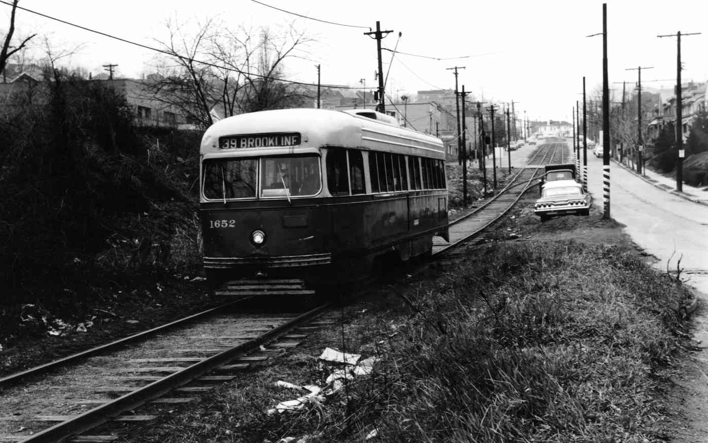
An outbound 39-Brookline trolley passes
Birchland Street on its way to the loop, in 1966. When streetcar service
was discontinued, the right-of-way from Breining to Edgebrook
was completely paved for vehicular traffic.
Nostalgic streetcar enthusiasts
who still yearned to ride the rails were delighted when, in 2004, a modern
light rail station was installed in Brookline along the Shannon route.
Known as South Bank Station, the loading platform is located off of Jacob
Street in East Brookline.
Another link to Brookline's
streetcar heritage was restored in 2011, when during a restructuring
of existing bus services, the Port Authority changed the local route
designation back to the traditional 39-Brookline.

A Pittsburgh Regional Transit 39-Brookline
bus approaches the Flatbush Avenue stop on November 9, 2024.
The Turbulence Of
The Late-Sixties
The late-1960s were an interesting
and confusing time in America, as well as here in Brookline. While the
Beatles ushered in the Summer of Love and the psychedelic years in 1967,
an undercurrent of discontent and angst filtered through the younger
generation.

Belmar Candy Company, across from the
cannon and veteran's memorial, on May 25, 1965.
The counter-culture movement and
rebellious vibe led to increased drug activity and crime. This soon evolved
into a nagging problem within in the community. The city responded with an
increased police presence along the boulevard.
Along with heightened racial
tensions and resentment over America's role in the Vietnam War came an
upsurge of illicit and disruptive behavior. The boulevard and rear
alleyways gained a conspicuous reputation as a rather shady area in the
evening hours.

The Foodland Super Market on Brookline
Boulevard in 1967. This is the location of present-day Pitaland Bakery.
Due to the diligence of the
citizenry and the bold actions of law enforcement officials, the problem
never reached alarming proportions. Brookline has traditionally been a
community that rallies together to combat crime. This was a time
that best illustrates that cooperation.

Showing Signs Of Age
In The Super Seventies
The decade of the 1970s were a
difficult time for the Steel City. Although the Pittsburgh Pirates
and the Pittsburgh Steelers combined to give Pittsburgh the honorary title
"The City of Champions," beneath the exhultation shown our beloved hometown
baseball and football teams laid the bitter struggles of a region losing
it's true identity.
The once imposing steel industry,
described by publishers as "Hell With The Lid Off," was in the midst of
a decline that would ultimately lead to it's demise in Pittsburgh. The
burgeoning steel crisis, and other setbacks in the corporate and
industrial base, left Pittsburghers to watch helplessly as the city faced
the loss of its national image.

Despite the splendor and pageantry
of the Bicentennial celebration in 1976, the nation itself was suffering
from the sting of a prolonged recession. Political corruption was front
page news and the lasting effects of the Vietnam War left the country
bitter and divided.
Here in Brookline, the seventies
were a also time of change. On the upside, long-awaited improvements were
being made to Brookline Park. On the downside, the economic slide forced
many residents to move out of the area and compelled others to adjust their
spending habits. This put strain on the boulevard merchant sector.

Firemen inspect damage to the Brookline
News Agency, Tryson's Shoes, Sesto's Barber Shop and Zitelli's Boulevard
Gardens after a fire on May 31, 1973. Also suffering minor damage in the blaze
was Melman's Super Market.
One disaster that left an
indelible mark on the boulevard was a fire on May 31, 1973. The blaze burned out of control for two hours,
destroying two buildings and damaging three others. Claims totaled over $75,000.
The lots were cleared and remained vacant for eight years.
Brookline's once magnificent and
modern boulevard was beginning to show signs of old age. To make matters
worse, impressions of inner city blight and tension began to creep into
the fabric of the neighborhood.

By the latter part of the Super
Seventies, the once-thriving East Brookline Shopping Center had been all but
shuttered. Another devastating fire had done irreparable damage to much of
the structure and only a convenient store was still in operation. Graffiti,
litter and boarded windows foretold the imminent closure of that
neighborhood landmark.
The late-seventies saw the beginning
of a downturn in the fortunes of Brookline Boulevard. By the end of the decade,
the local population had declined by over 4000 residents. Throughout the
community, "For Sale" signs were becoming a common site and there were already
a handful of vacant storefronts along the boulevard.

The East Brookline Shopping Center was a
popular destination for those living in the 32nd Ward since the 1940s.
Shown here in the mid-1970s, the complex was razed in 1980 for construction
of an apartment building.
Also shown are long-time boulevard establishments Mary and Bob's Restaurant
and Jay's Hardware.
One regional development that, in the
near future, would have a profound effect on the local Commercial District
was the 1979 opening of Century III Mall in West Mifflin.
Located only a short drive from
Brookline, the modern shopping mall, and the sprawling retail complex that
grew around it, led to a major shift in consumer spending. The small
business community would soon experience the lasting effects of this
national trend. Although Brookline's commercial district was still thriving
there was trouble on the horizon.

A Resurgence Of
Pride In The Early-1980s
The final two decades of the 20th
Century were a time of both highs and lows. These years began with a
flurry of positive energy. Through the hard work and dedication of the
Brookline Area Community Council and the Chamber of Commerce, the
neighborhood was recovering from the turbulence and neglect of the past
several years.
Brookline Boulevard was the scene
of two major construction projects. In 1982, both the Mazza Pavilion and the Parkside Manor senior highrise apartments opened their doors to new tenants.
The Mazza building occupied the vacant lots along the 900-block and
Parkside was built on the site of the former East Brookline Shopping
Center.

Members of the Brookline Area Community Council
in 1982 looking over
an informational pamphlet on the Community of Brookline.
That was also the year that the
extensive decade-long renovation of Brookline Park, along the 1400 block,
was finally completed. The public recreation facility now included a large
multi-purpose field, two Little League baseball fields, a swimming pool,
tennis courts, basketball courts, playground, abundant greenspace and a
state-of-the-art Activities Building.
Brookline Boulevard was milled and
paved for the first time in fifteen years, along with some minor
infrastructure improvements. Several merchants seized the moment and
remodeled the interior and exterior facade of their aging
storefronts.
The new road surface and facade
improvements, along with Brookline's glimmering new park and modern apartment
buildings were a breath of fresh air all along the formerly stagnating
boulevard. T-Shirts printed by the Community Council and available at merchant
locations during that time period proudly proclaimed Brookline
as a "Special Place."
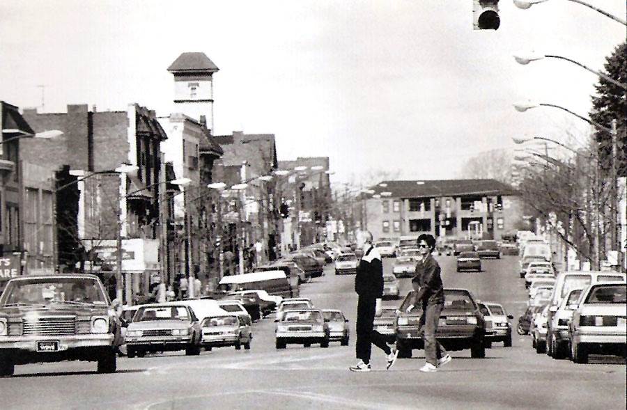
A view along the Brookline Boulevard Commercial
District, looking from near Glenarm Avenue in 1985.
To celebrate this resurgence of
community spirit throughout the neighborhood, a festival was held in
Brookline Park in June, and the inaugural Brookline Breeze 5K Fitness Run was held on September 3, 1982. Both
events were very successful. The Junefests continued until 1986 while the Brookline Breeze celebrated its
38th running in August 2019.
For many years the Brookline Chamber of
Commerce held an annual sidewalk sale along the boulevard. When the Brookline Breeze
began in 1982, the Chamber scheduled the sidewalk sale to coincide with race weekend.
Along with the race day bargain bonanza was a three-day schedule of events that became
one of the highlights of the summer season.
Today, the event is called the Boulevard
Breezefest, a sidewalk sale and community celebration featuring a variety of
attractions. Below is an advertisement that ran in the Pittsburgh Press on August
11, 1988, announcing "Happy Days" along Brookline Boulevard.

Big Business Versus
Small Business
Despite the upbeat mood of the
early-1980s, negative undercurrents were beginning to swirl and would
soon begin to tug at the very fabric and makeup of the boulevard Commercial
District.
The success of the suburban shopping
centers and the dawn of the super-stores began to take a heavy toll on many
of the local small business owners along the boulevard.
Some of the hardest hit were the hardware
stores, grocers, clothing outlets and appliance stores. The small businessman
in many instances was unable to compete with the large volume franchise stores.
As a result, retail sales at boulevard merchants plummeted as local shoppers
migrated to the suburbs in search of bigger selections and better
deals.

A panoramic view of Brookline Boulevard in 1985
-- Photos by Michael Haritan.
In the latter part of the 1980s,
a succession of long-standing boulevard businesses were forced to close their
doors. While the number of vacant storefronts continued to rise, community
organizations searched for answers to stop the downward trend.
Establishments that did well during these
changing times were specialty retailers, bars, restaurants, pizza shops and
other service-oriented stores.
During these lean years, the solution seemed
elusive, and concerned citizens watched as their once-vibrant boulevard slipped
rapidly into a distressed state. Meanshile, the Chamber of Commerce clung to hopes
of recovery and members did their best to weather the storm.

A 1990 painting by local
artist Robert Daley of South Hills Art Center
entitled "A Boulevard Sunset."
A Time Of Renewed
Hope
The downward trend continued into the
final decade of the 20th Century. The population continued to drop as more
and more families moved to homes in the suburbs. The exodus led to a
further decline in appearances along the boulevard.
For the majority of Brookliners, life
went on as usual. The nation's economy was on an upswing. However, the state
of Brookline's main street was in doubt. The Chamber of Commerce, along with
other community action groups and city officials, searched for ideas to bring
new life to Brookline's struggling commercial center.
 
The construction of the CVS Pharmacy at Pioneer Avenue acted as a catalyst in the
revitalization of Brookline Boulevard.
One significant change that took
place in 1999 was the razing of the four buildings at the corner of Pioneer
Avenue for the construction of a modern CVS Pharmacy. The new boulevard
attraction was to be the western anchor in the revitalization of the merchant
sector.
It was unanimously agreed that the
boulevard was the beating heart of the community. Over 4000 vehicles, and
hundreds of pedestrians, passed by the commercial district on a daily
basis. The success or decline of the boulevard would set the tone for the rest
of the neighborhood.
Sixty years had passed since the
last major overhaul of the boulevard had taken place. The roadway conditions
were becoming a source of frustration and the basic infrastructure was
crumbling. This was a deterent to new investment and became the primary
focus of attention.
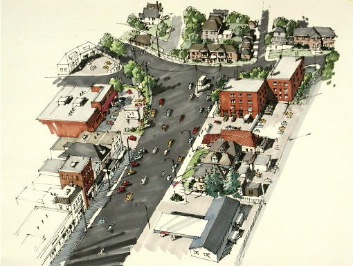 
Sketches showing the planned redesign of the
Pioneer Avenue/Brookline Boulevard intersection. These preliminary
drawings show only a portion of the proposed refurbishment of the boulevard
commercial district.
After much deliberation, and assistance
from city and state officials, plans were put on paper that outlined an
initiative that would dramatically change the look of
Brookline Boulevard.
As the clocks ticked towards the dawn of
the 21st Century, it was a time of renewed hope for Brookline Boulevard and
the entire neighborhood.
The New Millenium
Brings Positive Change
The path to recovery began in
the Spring of 2000, when design plans were presented for a complete
reconstruction of Brookline Boulevard. City Councilman Michael Diven
worked to secure federal funding to cover the cost of the
multi-million dollar project.
The South Pittsburgh Development
Corporation, a neighborhood community-action volunteer organization, took
the lead on the initiative and, together with the Urban Renewal Authority,
secured grant money to assist shop owners to refurbish their storefront
facades.

Brookline Boulevard was full of vendors and
party-goers during the Autumn Moon Festival in September 2000.
Positive changes were beginning
to take place, and for the first time in several years, there was an
influx of new merchants setting up shop in long-vacant storefronts.
Many older establishments took advantage of the available grants and made
improvements to their stores.
Just as the situation was beginning
to improve, the City of Pittsburgh suffered a brief fiscal crisis. Funding
for the boulevard reconstruction project was held in limbo while the city
struggled to achieve financial stability.
Community groups came forward in 2009
with a joint effort to resurrect the project. With help from State
Senator Wayne Fontana, State Representative Chelsa Wagner, and Pat Hassett
of the City of Pittsburgh, the long-stalled initiative regained
momentum.

Brookline Boulevard in May of 2011,
showing the reconstructed Frank Mazza Pavilion.
Another major building project was
the refurbishment of the Mazza Pavilion apartment building. In 2004, the
building was closed due to structural defects and was scheduled to be
demolished. Instead, the Housing Authority approved a plan to reconstruct
the building. Work began in 2010 and the glimmering new apartment complex
reopened to tenants the following year.
It would be another four years before
the massive boulevard reconstruction project would begin. In that time, work
continued on attracting new investment to the main street. Signs of recovery
could be seen all along the main street. Times were changing for the better
in Brookline.

The Boulevard
Reconstruction Project
The long-awaited Brookline Boulevard Reconstruction Project began on February 25, 2013. During this monumental
undertaking, the entire roadway, including sidewalks and infrastructure,
was rebuilt. The construction zone stretched from Pioneer Avenue to Starkamp
Avenue.
The $5.35 million project was
scheduled to be completed in the Fall of 2013. Merchants, pedestrians and
motorists all suffered from the inconveniences encountered during the long
construction period. They further chafed when it was announced that the
completion date would be postponed until the Spring of 2014.
 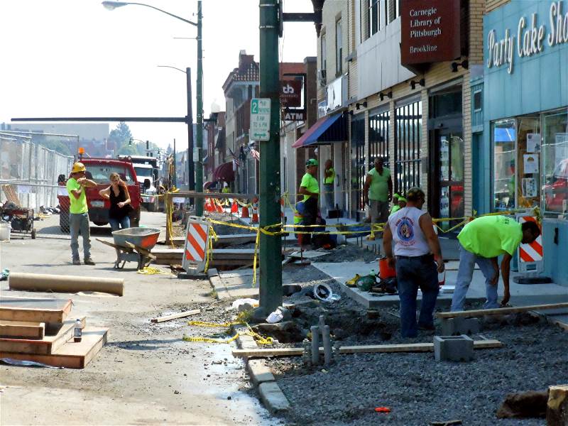
New utility lines were put in place
and all of the sidewalks were replaced. Progress was slow but steady.

The Brookline Chamber of Commerce reminds
the community that small businesses remained open throughout the project.
 
Work proceeds near that Castlegate Avenue
intersection (left) and at Pioneer Avenue. Throughout the seventeen-month
construction period, contractors managed to maintain access to all of the
merchant establishments and keep
traffic flowing along the boulevard. This was no small task considering the vast
scope of the project.
On May 6, 2014, long-suffering
motorists got a taste of good things to come when the lower end of the
boulevard, from Starkamp Avenue to Birchland Street, was paved by the city. All around the neighborhood there was a growing wave of
welcome relief among residents and merchants that the long and arduous
journey was nearing its end.
Then, on June 28, in the final
act of the seventeen-month reconstruction effort, crews arrived to begin
laying a smooth layer of black top along the commercial district. Three weeks
later, when the top coat of asphalt was sealed and the new lines painted,
the transformation of Brookline Boulevard was complete. The results were
splendid.
 
Paving of the lower boulevard,
near Whited Street (left), and the Commercial District at Starkamp Avenue.

Brookline's new boulevard, shown here on
July 24, 2014, after the completion of the reconstruction project. The main
thoroughfare now features a unique blend of vintage 20th century
architecture and modern 21st Century technology.
A Dedication Ceremony was held on July 24, 2014, attended by Mayor
Bill Peduto, State Representative Erin Molchany, Councilwoman Natalia Rudiak,
several local dignitaries and many others who had contributed to the project.
After over a decade of planning and
many months of construction, Brookline Boulevard had taken on the look of an
ultra-modern urban thoroughfare. In the Commercial District, all overhead
wiring was removed and the amenities on ground level were new. Below ground,
the water, electric and sewer lines were replaced.
Decorative landscaping was put in
place and adjusted traffic patterns increased parking and pedestrian
safety. All this was accomplished while retaining much of the vintage look
of the old boulevard, further increasing the unique character and
charm of this community jewel.
 
The boulevard as seen from atop
the extended firehouse ladder truck, looking both directions from Castlegate
Avenue.
Brookline Boulevard - The
Heart Of It All
It was over 100 years ago that the
West Liberty Improvement Company and the Freehold Real Estate Company
gave birth to Brookline Boulevard as the main street around which the
Community of Brookline would grow and proper.
During that century, Brookline has
evolved into what many refer to as a "Suburb In The City." It has, and will
continue to be, a great place to live and raise a family.
Today, the Commercial District along
Brookline Boulevard is once again a vibrant center of activity. Since the
reconstruction project, an influx of young professionals have brought
investment dollars back into the community.
Our neighborhood Main Street has a
long and distinguished history. Throughout its many years of service, for
the generations of local residents whose fortunes have grown and thrived
along with it, Brookline Boulevard has, and will continue to be,
the heart of it all.
 
An Autumn sunrise as seen from the top
of the Brookline firehouse tower on October 7, 2014.

Some Articles Featuring
Brookline Boulevard

Post-Gazette - April 22, 2010:
"Brookline Neighborhood's Business District Is
Just Right For A Food Walk"
Post-Gazette - August 11, 2010:
"Storytelling: Breezin' in Brookline - Memories
from a Neighborhood Race"
Pop City - March 16, 2011:
"The Pop City Guide To
Brookline"
Post-Gazette - April 24, 2012:
"City Walkabout: Newcomers Find They
Have Appetite For Busy Brookline"
Post-Gazette - January 17, 2013:
"Pittsburgh OKs Initial Funding To Rehabilitate Brookline Boulevard"
Post-Gazette - July 24, 2014:
"Brookline Boulevard Reopens, Business Owners Rejoice"


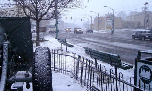
The boulevard on a blustery late-autumn
day, in November 2008, looking west from Triangle Park.
Links To Photos Of Brookline
Boulevard
Past And Present |