|

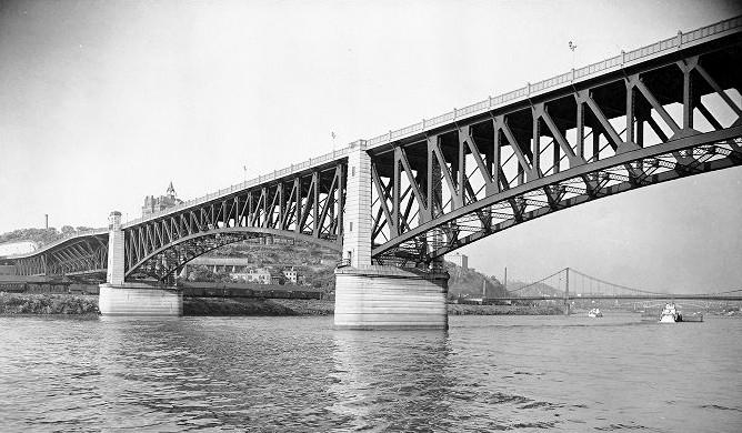
The Liberty Bridge, spanning the
Monongahela River, shown here on April 30, 1937.
The opening of the Liberty Tunnels in January 1924 was a major transportation development, linking
the growing South Hills neighborhoods with the downtown area. However, once
arriving on the other side of Mount Washington, motorists were routed to Arlington Avenue, then on to Carson
Street and the Smithfield Bridge to cross the Monongahela River in order
to reach the city center.
The need for an accompanying bridge
was always a part of the master plan. It was vital to the continuing
development of the entire South Hills region. Construction of the Liberty
Bridge began in 1925 and it was ready for a grand opening in the Spring of
1928.
Now approaching 100 years of service,
the venerable bridge has stood the test of time, and continues to be a key
part of the Pittsburgh transportation network. For many who live or work
in the South Hills, it's part of our daily life.
History
of the Liberty Bridge
♦ History of the Liberty Tunnels ♦

The Liberty Bridge in 2012, eighty-four years
after the grand opening in March 1928.
New Bridge is Needed
Although the tunnels made a huge difference
in travel time from the South Hills to the North Face of Mount Washington, getting
to the downtown city center still required a right turn onto a ramp to Arlington
Avenue (called Brownsville Road at the time), then heading downhill to Carson Street
and across the Smithfield Street Bridge. The resulting congestion was relieved by
the construction of the Liberty Bridge.
From the time talk began of a tunnel
through Mount Washington began there was discussion regarding a bridge across
the Monongahela River to link the tunnel directly with downtown
Pittsburgh.

Original plans for the Liberty Bridge, made
public in May 1919.
When work
began on the tunnel in 1919 plans were made public showing the proposed new
bridge. The plans above show a completely different configuration for the northern
approaches, with a different path for the proposed Boulevard of the Allies along with a Fourth Avenue Viaduct and Sixth Avenue extension
to Second Avenue.
Varying Design Proposals
Expectations were that work on this span
would begin shortly after the Liberty Tunnels were complete in January 1924,
but that did not happen. Further designs were put forth, with varying
proposals put forth for northern and southern approaches.


Early artist's conception of the proposed
north and south end bridge design.
Another competing version had the northern
ramps joining Shingiss Street and a Sixth Avenue Viaduct along with the current
Boulevard of the Allies design.
Additional studies were initiated, causing
delays. Further postponements came when the city was delayed in getting approval
for the bond issue necessary to fund the project.

A later artist's conception showing the
actual off ramp configuration on both northern and southern ends.
A $30 million bond issue was approved to
cover several large improvement projects. In addition to the Liberty Bridge, the
bond covered the construction of Mount Washington (McArdle) Roadway, the Armstrong
Tunnels, construction of the County Office Building and numerous road
improvements.
Bridge Piers
Work began in August 1925 with the
construction of the bridge piers. A huge caisson was launched from Neville Island,
built by the Dravo Contracting Company. The caisson was towed upriver and
positioned to begin the pier construction.
The caisson was sunk below the river bottom
until it reached bedrock, twenty feet below the river bed. Way down below the
river, crews of fifteen men, working eight hours a day at double normal atmosphere,
worked to clear away mud from under the caisson to reach bedrock.

The launching and towing of the caisson for
the Liberty Bridge on August 18, 1925. On hand for the occasion were
F.C. Beinhauer, Daniel Winters, presidentof City Council, E.T. Whiter,
regional vice president of the Pennsylvania
Railroad, County Commissioners Joseph G. Armstrong and E.V. Babcock, M.W. Clement,
general manager of the
Pennsylvania Railroad, Judge Charles H. Kline, R.M. Dravo, vice president of the
Dravo Contracting Company,
County Commissioner James Houlahen, Judge J. Carpenter and County Controller
John P. Moore.

Clearing mud and taking a rock sounding in the
south river caisson on September 25, 1925.

Working at the caisson for the southern
pier of the Liberty Bridge in August 1925.

Construction of the piers that would
support the Liberty Bridge as it crosses the Monongahela River.
Once the piers were in place, the steel
frame was erected from both shores extending towards the middle. On June 15,
1927, both ends were joined. Another nine months would pass before construction
was finished.
Liberty Bridge Construction Photos

Work begins on southern approaches to the
Liberty Bridge in December 1925.

Work begins on southern approaches to the
Liberty Bridge in December 1925.

Progress of the bridge construction as of
October 24, 1926.
 
The bridge span extends from the approaches
at the southern (left) and northern ends on February 4, 1927.

The northern end of the bridge extending
over the Baltimore and Ohio Railroad yards on March 16, 1927.
 
The bridge span extends a bit further and
is now over the banks of the Monongahela River
at the southern (left) and northern ends on March 16, 1927.

Work proceeds along the southern section of
the bridge deck as the cranes move steadily forward along tracks.
 
The southern end of the bridge extends further
over the Monongahela River, braced by falseworks, on April 8, 1927.
 
The northern end of the bridge continues to
extend over the Monongahela River on April 8, 1927.
 
Work beginning on the Boulevard of the Allies
ramps (left) and the two bridge sections nearing on June 6, 1927.

The Liberty Bridge under construction on
June 15, 1927.
 
The two bridge sections were joined in the
middle on June 15, 1927.

Ironworkers attaching the beams that
connected the southern and northern ends of the bridge.

Looking south at the joining of the two
sections of the Bridge on June 15, 1927.

A view of bridge construction from the
Boulevard of the Allies in July 1927.

A view of bridge construction from the
Boulevard of the Allies on August 12, 1927.

Greater Pittsburgh - The New Liberty
Bridge - March 10, 1928.

The Liberty Bridge on March 12, 1928, two weeks
before the grand opening.

Work proceeds on the traffic circle at the
southern end of the bridge on March 12, 1928.

A view of the completed bridge on the
day before the dedication on March 26, 1928.
Retaining Wall Construction on North Approach
The bridge design called for
construction of three retaining walls along the northern approaches. Two
smaller walls, one along the upper Bluff and another along the Pennsylvania
Railroad car yard were needed, in addition to a massive wall along the
mass of the hillside. A large cut into the Bluff was necessary to clear the
path for the lower ramps to connect to Forbes Avenue.

The large retaining wall along the north
approach under construction on October 28, 1927.
Booth and Flinn began work on the walls
in March 1927. The main sloping wall was one of the highest of its type in the
world, rising ninety feet from ground level, with long anchor beams embedded in
the rock and attached to the concrete, making it an integral part of the
hillside. Over 350,000 cubic feet of earth and rock were removed during the
eleven month project, which was completed in January 1928.

The Bluff Hillside, covered in billboards, on
July 13, 1921. The Boulevard of the Allies and subsequent Liberty Bridge
construction required substantial excavation and cuts into the hillside and
ground-breaking engineering.
 
Conditions at Forbes Avenue in March
1927 (left) and the beginning of the Bluff excavation in April.

Beginning the construction of the high
wall along the Bluff in April 1927.

The lower wall along the Pennsylvania
Railroad car yard extending to Forbes Avenue in June 1927.
 
The lower wall at Forbes Avenue (left)
and work proceeds with the hillside excavation in June 1927.

Conditions during the excavation of the
hillside in June 1927.

The beginning of the sloping retaining
wall at Forbes Avenue in July 1927.
 
Excavations along Shingiss Street and
the first sections of the main retaining wall in July 1927.

350,000 cubic feet of earth and rock were
hauled away from the cut one truckload at a time.
 
Two views of the hillside excavation. At its
peak, the retaining wall would rise ninety feet.

Excavation at the Boulevard of the Allies
Viaduct One in July 1927. The bridge ramps to Forbes Avenue
would extend through the viaduct, under the broad boulevard and over
Second Avenue.

The excavation was complete in September
1927 and work was beginning on the tall section of the retaining wall.
 
Two views of the sloping wall as it rises
in sections in October 1927. Long anchor beams were pounded into
the rock and attached to the cement wall, making the wall an integral part of
the hillside.

The sloping wall was considered the
highest of its kind in world at the time of construction.

Workers for Booth and Flinn at work
building the upper sections of the sloping wall.

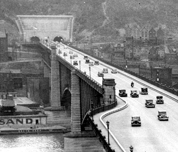
A view of the Forbes Avenue exit
in 1951, before the Crosstown Boulevard ramps were built.
Highest and Costliest Span
At the time the Liberty Bridge
was completed in March 1928, it was the largest, tallest (113 feet above the
water level at it's highest point) and costliest span ($3.436 million) built
in Allegheny County. Some said that the construction of the bridge was
"one of the most pretentious projects ever undertaken."
The Pratt deck truss bridge measures 2663
feet in length, featuring two 450' cantilevered main spans over the river. The
driveway was thirty-eight feet wide and two sidewalks measured eight and a half
feet in width.
Constructed of steel and concrete, with
granite facing on the piers to the water's edge, the bridge contains 11,000 tons
of structural steel. The pavement was asphaltic concrete with a concrete
base.
All phases of construction were completed
by mid-March and the city of Pittsburgh prepared for the grand opening, to be
held on March 27, 1928.
Liberty Bridge Dedication
The Liberty Bridge was dedicated on
March 27, 1928. Coupled with the opening of the Liberty Tunnels in 1924, the new bridge was a major achievement for the City
of Pittsburgh in the advancement of its evolving transportation network.
The combined cost of the new tunnels and bridge was $9,400,000.

A parade of automobiles streams across
the Liberty Bridge on Dedication Day - March 27, 1928.
The day began in Mount
Lebanon, where the largest motorcade in the history of the City of Pittsburgh
had gathered. The five mile long procession flowed north on West Liberty
Avenue through Dormont and Brookline, then turned left onto Warrington Avenue.
It passed through Beltzhoover and Allentown, then onto Arlington
Avenue.
The parade of vehicles winded down
the hill to Carson Street, then crossed the Smithfield Street Bridge and
moved on to the Boulevard of the Allies. When it reached the intersection
with the bridge the lead car came to a stop.

City, County and State officials were
on hand to dedicate the bridge and restart the procession. The honor of
actually cutting the red, while and blue ribbon went to Allen H. Lemon, aged
seven, of 919 Carson Street, and Joseph G. Armstrong III, aged two, grandson
of County Commissioner Joseph Armstrong.
Once the ribbon was cut the vehicles,
four abreast, slowly crossed the bridge and continued on through the tunnels,
then back up West Liberty Avenue to the starting point. The motorcade
continued for ninety minutes while crossing the bridge.

Another image of the Liberty Bridge dedication
on March 27, 1928.
The tunnels themselves shortened the
travel time from the South Hills to downtown significantly. The accompanying
bridge lessened that time even more. A motorist could now get from the
intersection of Saw Mill Run Road and West Liberty Avenue to downtown
Pittsburgh in less than five minutes on a good day.
Only five years earlier, the same
drive took nearly an hour or longer. Prior to the advent of the automobile,
that trip could last several hours. The Liberty Tunnels and the Liberty Bridge were responsible for a near quadrupling of
property values in the South Hills.
The Liberty Bridge in 1928, shortly after
the March dedication. Tha span towers over
all other Monongahela River bridges in Pittsburgh's Golden Triangle.
Traffic Circle and Safety Concerns
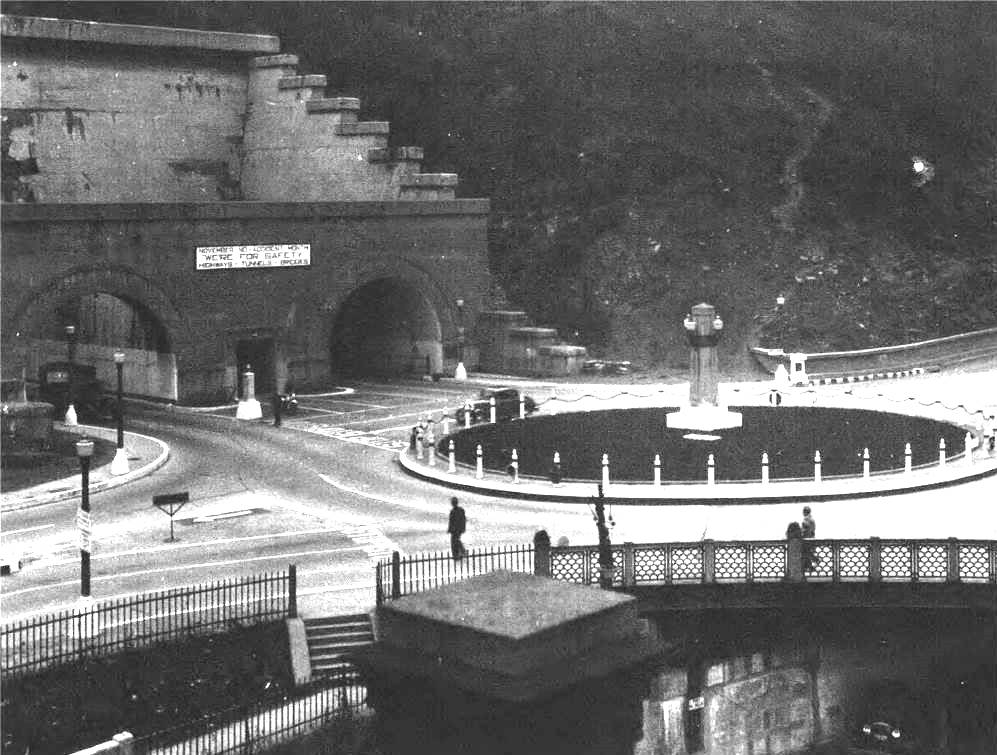
The North Portal of the Liberty Tunnels
and the traffic circle shown here in 1930.
The northern bridge approach, outside
the tunnels, was adorned with a decorative traffic circle containing a monument
to Liberty. In time, as the flow of traffic increased, this large circle became
a hindrance to smooth vehicular flow.

The traffic circle at the tunnel entrance
was condensed in 1933.
In 1933, in an effort to increase safety
at the busy intersection, the traffic circle was condensed to facilitate the
ever-increasing flow of vehicles. By the 1940s, the circle had been reduced to
a small island with a traffic signal.
Another early safety improvement for
motorists and pedestrians using the bridge was the 1935 installation of heavy,
reinforced concrete guard rails along the sides of the roadway. This was
to prevent out-of-control vehicles from plunging off the bridge.

Pouring concrete for the installation of
guard rails on August 29, 1935.
Mount Washington Roadway
Mount Washington Roadway, which scales the Coal Hill cliffside from the Liberty Tunnel entrance
to Grandview Avenue, opened in July 1928, just four months after the Liberty Bridge
dedication.
In another major improvement for South Hills
residents, coupled with the Liberty Bridge, the Mount Washington Roadway provided
another timely option to reach downtown Pittsburgh, and a convenient detour in case
of tunnel closure.
Later renamed McArdle Roadway, this major
civic improvement provided further fuel to the escalating real estate values of
South Hills property.

A view of the Liberty Bridge from the Duquesne
Bluff, looking to the southwest, shortly after opening in 1928.
Also visible is the Mount Washington Roadway, running up the
side of the hillside to Grandview Avenue.
Liberty Bridge Improvements - 1982/1984
In 1976, the Liberty Bridge, which handled
45,000 vehicles a day, was beginning to show serious signs of deterioration. Fifty
years of wear and tear had taken it's toll on the majestic Pittsburgh
span.
A fifteen ton weight restriction was placed
on vehicles and the sidewalks were closed. In places, small sections of the walkways
had completely worn down to the point where a pedestrian could look through the steel
rebar strips to river below.

The new road surface was poured on the
outbound lane by April of 1983.
In April 1982, a $31 million bridge rehabilitation
project was begun. Traffic continued to flow on a limited basis throughout the two-year
construction period, with one lane open in each direction. During weekdays, the traffic
flow was either inbound or outbound for twelve hour periods.
The bridge was completely refurbished, from
the steel superstructure to the sidewalks, deck, road surface and other infrastructure.
Four million pounds of structural steel and over one million rivets were replaced.
Several thousand cubic feet of concrete were poured around the crumbling
piers.
 
Ironworkers made major repairs to the bridge
superstructure. The boat sitting idly down on the
river was a safety precaution in case any of the workers
accidentally fell into the water.
Changes to the bridge included the addition of
240 braces that were attached to both sides to make the span sixteen feet wider.
The bridge was also repainted in Aztec Gold, in lieu of the former Silver coat, to
match other Pittsburgh bridges. The Liberty Bridge rehabilitation was completed
in the summer of 1984.
Liberty Bridge Improvements - 2016/2018
In April 2016, PennDot kicked off a three-year,
$87 million construction project on the aging bridge. The project, which was
carried out by Joseph B Fay Company, included deck replacement, ramp reconstruction,
a new walkway, structural steel repairs, painting of the entire structure and concrete
repairs.

The outbound deck being replaced while three
lanes of traffic proceed to the right.
Signage improvements were made and a new
overhead lane control system was installed to allow the direction of traffic flows
to be switched. The overall project was completed in July 2018.
When the reconstruction project was completed,
the venerable Liberty Bridge looked better than ever and is in condition to serve City
of Pittsburgh motorists without need of major repairs for the next several
decades.

An Dave DiCello print showing the Liberty Bridge
in 1933 superimposed on a picture of modern Pittsburgh.
Fire Nearly Causes Collapse
On September 2, 2016, during the bridge
rehabilitation project, a careless mishap came close to causing a catastrophic
bridge collapse.
Sparks from a welder cutting steel
ignited plastic ventilation pipe and a construction tarp. The items quickly
engulfed that area in flame, with the PVC products burning at a temperature
of over 1,200 degrees.
It took Pittsburgh firefighters about
a half-hour to put out the blaze.

The Liberty Bridge on fire
- September 2, 2017.
 
The accidental blaze burns under the Liberty
Bridge (left) while firefighters work quickly to extinguish the flames.
When the fire was extinguished it was
discovered that the intense heat had caused one of the major structural beams to
warp at a critical juncture. The damage was so significant that there were fears that
the historic bridge could collapse.
Construction was halted for several weeks
and, once bridge stability was secured, severe weight restrictions were
implemented.
In the meantime, experts from Carnegie Mellon
and Lehigh Universities designed a pair of 26.5-foot braces that were attached to each
side of the damaged chord. The repair was successful. All weight limits were removed
and construction restarted.

Construction workers reinforce the critical beam
damaged by the September fire.
Photos of Pittsburgh's Liberty Bridge
(National Register of Historic Places - 1988)

The Liberty Bridge as seen from the
Bluff looking south on April 16, 1928.

Cars enter the bridge off ofthe Boulevard
of the Allies north ramp on May 28, 1928.

The Liberty Bridge and the Northern Portals
of the Liberty Tunnels in August 1928, shortly after the opening
of another major South Hills traffic improvement, the Mount Washington (McCardle)
Roadway.

Bumper to bumper traffic outbound on May 17,
1932.

The Liberty Bridge in 1933. The traffic
circle outside the tunnels is being removed.

Pedestian, vehicular and horse-drawn traffic
passes over the Liberty Bridge in 1933.

The southern half of the Liberty Bridge
on April 20, 1936.
The Liberty Bridge and the North Portals of the
Liberty Tunnels in 1936.

Rush hour traffic on the Liberty Bridge
- August 10, 1937.

Liberty Bridge traffic is rerouted during
an outbound tunnel closure on March 13, 1939.

Repaving the pavement of the inbound
lanes on June 5, 1942.
The Liberty Bridge in 1951 during the height
of rush hour traffic.

Cars make the turn off the Liberty Bridge
onto the Boulevard of the Allies in 1951.

The Liberty Bridge in 1951 during mid-day
traffic. A large advertisement announces the Allegheny County Free Fair.

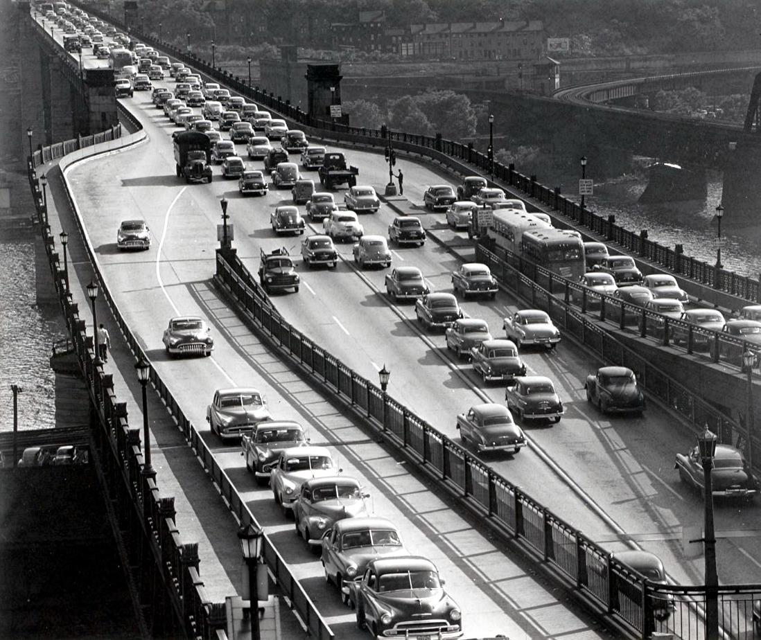
The Liberty Bridge in 1951 during the height
of the evening rush hour. As is still done today there are three
lanes heading in the outbound direction to accomodate the large numbers of
vehicles leaving the city.

The Liberty Bridge in 1951. Note
the Balantine Beer sign and clock on the Mount Washington hillside.
 
On May 16, 1952, this car blew a tire in
the tunnels, lost control on the bridge, crossed the divider and bounced
over the four-foot retaining wall, coming to a stop lodged on the
sidewalk between the wall and the bridge rail.
Two of the four occupants were injured. It took special tow trucks to remove
the car from the bridge.

A welder working on the cover plate at one
of the expansion joints on June 5, 1956.

The intersection of the Liberty Bridge and the
Boulevard of the Allies during rush hour in June 1958.

Three lands of traffic congestion heading
outbound during rush hour in June 1958.

A traffic cop mans his post on the southern
side of the bridge, outside the Liberty Tunnels on April 20, 1960.

Approaching the North Portals of the Liberty
Tunnels in 1973.

Reconstruction the lower part of McArdle
Roadway at the northern tunnel intersection on November 14, 1974
in preparation for the 1974-1977 Liberty Tunnel renovation project.

The Liberty Bridge, shown in 2004, is one of
several bridges spanning the Monongahela River in Pittsburgh.

The Liberty Bridge in 2009, looking south
from Second Avenue towards Mount Washington.

The Liberty Bridge in 2011, looking north
towards the skyline of Pittsburgh in the evening.

The Liberty Bridge in 2011, looking north
towards the skyline of Pittsburgh in the daytime.

The Liberty Bridge in 2013, as seen from
underneath the span along Second Avenue.
Vintage Postcards Of The Liberty Tunnels And Bridge

The North Portal of the Liberty Tunnels
shown on a postcard from the late-1920s.
 
Postcards from the early 1930s showing the
North Portals of the Liberty Tunnels and the traffic circle.

The Liberty Bridge in the late-1930s.
 
Postcards from the early 1930s showing the Liberty
Bridge, looking to the south (left) and towards downtown.
|
