|

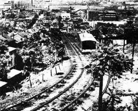
The Penn (17th Street) Incline descends over Bigelow
Boulevard from the Hill District to the Strip District. This
massive steel structure was the longest, and strongest, of twenty-four
inclines built in Pittsburgh.
< Links to the History of Pittsburgh's
Inclines >
Pittsburgh's hills were once dotted
with inclines, made of steel, wood, train rails, cables and vehicles that
scaled the hills surrounding the city. Called gravity planes, or funiculars,
the cars were pulled up, and lowered, using a system of cables and pulleys,
powered by large steam engines located in the upper station.
The inclines were a convenient way
to get from Mount Washington to Carson Street, Knoxville to the South Side, the Hill
District to the Strip, and other hilly areas around town. These classic
funiculars are forever linked to the history of Pittsburgh.
The Duquesne Incline offers a picturesque view
of the Golden Triangle (left) while the Pittsburgh Inclined Plane,
better known as the Knoxville Incline, winds it's way down to the South
Side.
The earliest inclines built were used
exclusively for moving coal from mining operations along Coal Hill to the factories below. Later, they became a popular
alternative for transporting passengers, wagons and freight. Pittsburgh had some
of the longest and steepest inclines in the world. Today, only the
historic Monongahela and Duquesne inclines
are still in existence.

The Monongahela Passenger Incline, built in
1870 and still in use today, is the steepest funicular in the world.
The adjacent Monongahela Freight Incline was in operation for fifty-one years,
from 1884 to 1935.
Altogether, there were a total of
twenty-four inclines built on the hillsides of Pittsburgh, ten of which were built
by the Monongahela Inclined Plane Company. The hilltop neighborhood of Allentown
alone had eight nearby inclines in service at one time: the Pittsburgh and Castle
Shannon Plane, Mount Oliver, Monongahela, Monongahela Freight, Castle Shannon, Castle
Shannon South, Knoxville and Keeling Coal Inclines.
During the first half of the 20th century
some local inclines averaged over 2000 riders a day. As time progressed and transit
opportunities increased, their popularity declined. By the mid-1960s, the coal planes
had long been dismantled, and financial hardships forced closure of all but two of
the passenger and freight inclines.

The lower station of the Castle Shannon Incline
on Carson Street in 1921.
Note: As for the eight that once
operated near Allentown: The Keeling Coal closed in 1928,
Pittsburgh and Castle Shannon Plane in 1912, Castle Shannon South in 1914, Monongahela
Freight in 1935, Mount Oliver in 1951, Knoxville in 1960 and Castle Shannon in 1964.
Pittsburgh Incline History Last Updated: April 9, 2024
  
History of Pittsburgh's
Twenty-Four Inclines
* Click highlighted links for a
history and images of the individual inclines *
♦ Ormsby Mine Gravity Plane * (1844-1878) - route location near the St. Clair Incline -
St. Patrick Street to South 21nd Street and Quarry Street - connected to narrow gauge
railway - Ormsby (Southside).
♦ Kirk Lewis Coal Incline/Hoist (1854-1870) - Grandview Avenue (formerly High Street) near the
present Duquesne Incline - Duquesne Heights (Mount Washington). Coal went directly
from mine opening to factories below via railroad.
♦ The Cray and Company Coal Incline (late-1800s) - upper station near Junius Street and Camden Street
(formerly Catherine Street and Hill Street - Westwood; lower station at Shaler Street
- West End Valley (Union Borough).
♦ Clinton Iron Works Coal Incline (late-1800s) - located on the hillside below Maple Terrace to West
Carson Street (formerly Washington Turnpike) near the present Station Square -
Mount Washington.
♦ Jones and Laughlin Coal Incline (late-1800s) - Josephine Street between South 29th Street and South
30th Street to Summer Street - Southside Slopes.
♦ Keeling Coal Incline * (1870-1928) - route similar to lower end of Mount Oliver
and Knoxville inclines, along Southside slope - from narrow guage railroad
exiting Keeling Coal Company mines to station at South 12th Street - Southside
Slopes.
♦ Monongahela Incline (1870-present) - West Carson Street at Smithfield Street Bridge
to eastern end of Grandview Avenue at Wyoming Street - Mount Washington.
♦ Pittsburgh and Castle Shannon Plane (1864-1912) - (known as the Mount Washington Coal Incline from 1864-1874)
route similar to Castle Shannon Incline from Neff Street (formerly Nimick Street) below
Bailey Avenue and William Street to East Carson Street at Arlington Avenue (formerly
Pittsburgh and Brownsville Turnpike) - Mount Washington.
♦ Mount Oliver Incline (1872-1951) - officially known as the South Twelfth Street
Inclined Plane - South 12th Street at Freyburg Street to Warrington Avenue - Mount
Oliver
♦ Fort Pitt (1882-1906) - from north end of South Tenth Street Bridge
to Bluff Street - Duquesne University Bluff.
♦ Monongahela Freight (1884-1935) - parallel to the east side of the Monongahela
passenger plane - Mount Washington.
♦ Duquesne Incline (1877-present) - West Carson Street opposite the Point to Western
End of Grandview Avenue (formerly High Street) between Oneida Street and
Cohassett Street - Duquesne Heights (Mount Washington).

Full Moon Over The Duquesne Incline
September 21, 2020 - Dave DiCello Photo
♦ Penn Incline (1884-1953) - over Bigelow Boulevard to Liberty Avenue,
from Ledlie Street to 17th Street - Hill District.
♦ St. Clair Incline (1886-1935) - (also known as South 22nd Street Incline) South
22nd Street and Josephine Street to Salisbury Street between Fernleaf Street and
Sterling Street - St. Clair Village.
♦ Bellevue and Davis Island
Incline (1887-1893) - Dilworth Run
ravine, from South Starr and West Bellevue following abandoned course of Oak Street
to Ohio River at Davis Island.
♦ Nunnery Hill Incline (1887-1899) - Federal Street at Henderson Street (formerly
Fairmount Street), North Side, to Catoma Street near Meadville Street
(formerly Clyde Street) - The first curved track incline in
Pittsburgh - Fineview.
♦ Troy Hill Incline (1887-1898) - near end of old 30th Street Bridge to Lowrie
Street at Ley Street, west of Lofink Street and Rialto Street (formerly Ravine
Street) - Troy Hill.
♦ Ridgewood Incline (1889-1900) - Charles Street North (formerly Taggart Street)
near Nixon Street to Ridgewood Street at Yale Street - Perry
Hilltop.
♦ Clifton Incline (1895-1905) - Strauss Street (formerly Metcalf Street and
Myrtle Street) on North Side to Clifton Park (Chautauqua Street) - Perry
Hilltop. The incline had only one passenger car. The other was a dummy car
used as a counterbalance.
♦ Knoxville Incline (1890-1960) - officially known as the Pittsburgh Incline
Plane - South 11th Street at Bradish Street to Warrington and Arlington
Avenue - The second incline in Pittsburgh with a curved track -
Knoxville.
♦ Castle Shannon Incline (1890-1964) - East Carson Street near Arlington Avenue to
Bailey Street - Mount Washington.
♦ Castle Shannon South (1892-1914) - Warrington Avenue to Bailey Street - Mount
Washington
♦ Norwood Incline (1901-1923) - Island Avenue near Adrian Street to Desiderio Avenue
between McKinnie Avenue and Highland Avenue - McKees Rocks/Stowe.
♦ Kund and Eiben * (1915-1929) - freight hoist along Saw Mill Run from P&WVRR tracks
above to Kund and Eiben Planing Mill on valley floor - Brookline/Bon Air.
* Dates for the Keeling Coal Company and Kund/Eiben inclines are approximate and based on available
maps and data.
Wikipedia: List of Pittsburgh
Inclines.
Bridges and Tunnels of
Allegheny County and City of Pittsburgh: Incline List.

A stereoscope image of the Monongahela Freight
and Passenger Inclines in 1905.
Images And Maps Showing
Pittsburgh's Inclines
Click on images for
larger pictures
The Knoxville Incline
(1890-1960)
 
The Pittsburgh Incline Plane, or Knoxville
Incline, was 2460 feet long and rose 375 feet with an 18 degree
curve midway.
It was one of two curved inclines built in Pittsburgh, running for seven decades,
from August 1890 to December 1960.
The upper loading platform (left), was located on Warrington Avenue. A car
(right) leaves the upper station.
 
The Knoxville Incline's cars moving along
both sides of the tracks, with the Mount Oliver Incline in the distance. The
Keeling Coal Incline is also visible in the photo on the left, wedged in
between the Knoxville and Mount Oliver planes.

A vintage color postcard image showing the
Knoxville Incline. It had a total length of a 1/2 mile and a 375-foot vertical
rise at a 14% grade. The incline was a double-track railway of nine-foot gauge,
with sixty pound rails laid on wooden
ties which rested on ballast or steel girders. Each car weighed about ten tons
and was specially designed to
carry street cars and other vehicles. An enclosed, heated compartment was
provided for passengers.
When it opened, the cost of the Knoxville Incline was $190,000 and the fare
a mere penny.
 
The Knoxville Incline looking up from the
lower station (left), with the Mount Oliver and Keeling Coal Inclines to the left.
A car moves along the curve (right), with the Mount Oliver Incline in the
distance.
 
The Knoxville Incline descends to its
lower station at South 11th and Bradish Street in the Southside.
 
The tracks of the Knoxville Incline (left)
and the upper loading platform.

The Knoxville Incline in December 1896. Note the
Keeling Coal and Mount Oliver Inclines to the right.
 
Looking up and down at the cars
of the Knoxville Incline.
 
The Knoxville Incline in 1956. Photos by W.
Eugene Smith.
Wikipedia: Knoxville Incline.
The Mount Oliver Incline
(1872-1951)

The Mount Oliver Incline
(circa 1890-1910).
 
The Mount Oliver Incline descends from Warrington
Avenue towards the Freyburg Street station (left) and a view
from the side. Built in 1872 by engineer John Endres, the incline was in operation for
seventy-nine years,
closing on July 6, 1951. The Mount Oliver Incline was 1600 feet long and rose
377 feet.
The construction cost of the Mount Oliver Incline was $150,000.
 
The Mount Oliver and Knoxville Incline cars pass
on their way from the hilltop neighborhoods to the flats (left), and the
lower station of the Mount Oliver Incline (right) at Freyburg Street on the Southside, between
11th and 12th Streets.
Once boasting 1200-1400 daily passengers paying the three cent fare, by 1950 ridership
had decreased 200 per day.

The Mount Oliver Incline, looking down from the upper
station along Warrington Avenue.
Wikipedia: Mount Oliver Incline.
The Pittsburgh and Castle Shannon Plane
(1864-1912)

An illustration entitled "On Carson Street, South
Pittsburgh, 1875" that appeared in "Fleming's Views of Old Pittsburgh."
It shows the Pittsburgh and Castle Shannon Plane a couple years after the P&CS railroad took
over the line and began
passenger service. On Carson Street was a coal distribution platform and a loading
station/office building. This
drawing shows the northern portal of the old railroad coal tunnel and the upper
coal depot/passenger station.

Map from 1882 showing the P&CSRR railroad depot on
the north face of Mount Washington and the
old coal incline, now used to ferry passengers also from the depot down
to Carson Street.
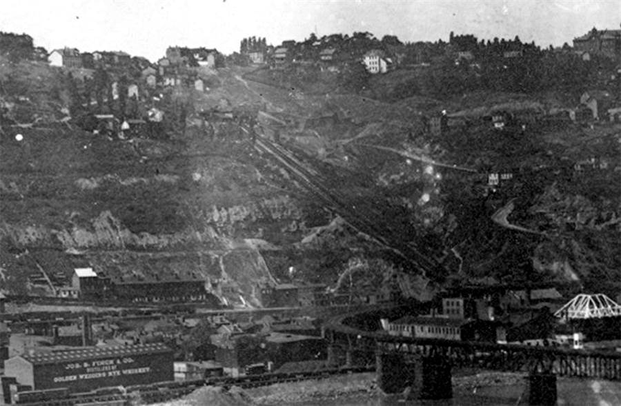
The Pittsburgh and Castle Shannon Plane, shown here in 1888,
was a low guage inclined plane used to transport coal mined
in the South Hills to industries located along the Monongahela riverfront. The Coal Railroad
traveled through the
Pittsburgh and Castle Shannon Tunnel to platform along the north face of Mount Washington. The
Pittsburgh
and Castle Shannon Plane was in operation from 1864 to 1912. Two years after this photo
was taken, in
1890, the Castle Shannon Incline was constructed to the left of the coal incline to
haul passengers,
wagons and freight. Until then, this traffic was lowered to Carson Street along
the P&CS Plane.
Wikipedia: Pittsburgh & Castle Shannon Plane/Mount Washington
Coal Incline.
The Castle Shannon Incline
(1890-1964)

The Castle Shannon Incline and the Pittsburgh and Castle Shannon Plane along Mount Washington in 1900.
 
The Castle Shannon Incline measured 1,350 feet
in length. Originally steam powered, the incline was electrified in 1918.
It was built to handle the passengers of the Pittsburgh and Castle Shannon Railroad,
which had a terminus nearby.
Later, after being acquired by the Pittsburgh Railways Company, the incline was a
popular way for hilltop
residents to get to and from town. As the years went by, ridership decreased and
the incline
became a perennial money pit. Efforts to close the incline began in the 1950s, as
yearly losses neared $50,000. Community efforts saved the historic structure
for a few years, but in 1964, the incline was closed and dismantled.
 
The tracks of the Castle Shannon Incline pass
under the McCardle Street Bridge, under construction in 1926 (left)
and a car stands at the Carson Street loading station that same year.

The Castle Shannon Incline's upper boarding
station is visible in this August 1928 photo taken from The Bluff.
The Mount Washington Roadway (McArdle Roadway) had opened to traffic only one
month before.
The incline passed down the valley beneath the concrete arch bridge.
The Castle Shannon Incline was the final
part of trip for passengers of the
Pittsburgh and Castle Shannon Railroad traveling north to the city from
1890 to 1912. The incline itself remained in operation until 1964.
 
The Castle Shannon Incline looking down
towards the McArdle Roadway Bridge and railroad trestle (left)
and looking up towards the Bailey Street Station (right) at the top of the
plane.

A postcard image (circa 1940) showing the
Castle Shannon Incline descending Mount Washington.
 
The Castle Shannon Incline descends
Mount Washington with the City of Pittsburgh and the Civic Arena
in the distance (left) and the Bailey Street Station at the top of the
incline.
 
The Castle Shannon Incline was a popular
transit route from atop Mount Washington for seventy-rour years.

The Castle Shannon Incline, from top to
bottom, passing under the McCardle Roadway bridge, in March 1936.
Along the side of Mount Washington is Pittsburgh's historic Coca-Cola clock.
 
Looking in both directions along the
rails of the Castle Shannon Incline.
 
The incline cars at the entrance to
the Bailey Street Station atop Mount Washington.
Vintage Pittsburgh postcards showing the
Castle Shannon Incline.

A postcard image circa-1912 showing the
Castle Shannon Incline (left) and the Pittsburgh and Castle
Shannon Plane (right), which was used to transport coal brought
from South Hills mines by the old
Coal Railroad, and later the Pittsburgh and Castle Shannon Railroad, from 1864 until 1912.
Wikipedia: Castle Shannon Incline.

Castle Shannon South
(1892-1914)
The Castle Shannon South descends along Haberman
Street in this undated photo. The incline ran from Bailey down
to Warrington Avenue, and was in operation from 1892 to 1914. Owned by
the Pittsburgh and Castle Shannon
Railroad, it transported passengers from Warrington to Bailey. Riders then
transfered to the Castle
Shannon Incline for the trip down the north face of Mount Washington
to Carson Street.
 
Looking from Warrington Avenue up Haberman
Avenue along the route of the Castle Shannon South Incline (left)
and the P&CSRR Warrington Station and Horseshoe Curve on the lower
end of the incline.
 
Looking up from near the lower Warrington station
(left) and looking down from near the top of the rise.
 
Cables along the tracks near the top of the
line (left) and a view towards the Bailey Street upper station.

This is a view of Haberman Avenue in 1925, heading
from the Warrington Loop up the hill towards Bailey Street.
The Castle Shannon South Incline, which operated from 1892 to 1914, ran parallel
to Haberman on the left.
Also visible to the far left are the old railroad tracks and station at the P&CSRR Horseshoe Curve.
On the hill above to the left is the newly completed second wing of South Hills High School.
Wikipedia: Castle Shannon South Incline.
The Penn Incline
(1884-1953)

The Penn Incline ferried passengers and freight
between the Strip District to Ridgeway Street in the Hill District. It was
one of the sturdiest inclined planes in the world. Built in 1884, it operated
until 1953. The large structure to the left of
the upper platform was a saloon and entertainment hall called the Penn
Incline Resort, which stood for eight years.
This resort was built by the Penn Inclined Plane Company to boost business.
It enjoyed early popularity, but soon
went into decline. The building was destroyed in 1892 by a fire that spread
from the incline's boiler house.
Note the rickety steps hugging the steep hillside to the left, an alternate
path for those short a fare.
 
A view of the Penn Incline in operation,
looking down on Pittsburgh's Strip District. Designed by Samuel Deischer, the
funicular measured 840 feet in length and rose 330 feet. The structure
contained over 750 tons of bridge work with
two ten-foot gauge tracks. The incline was originally built to hoist twenty-ton loads
of coal to the top of the hill.
Although this coal traffic never met expectations passenger and freight traffic
took its place and was enough
to keep the incline profitable. By the end of World War II business had decreased
to only fifty customers
a day paying the ten cent fare. With operations cut to only a few hours a day
during rush hour, the
incline was abandoned by its final owner, the Pittsburgh Railways Company, on
November 30, 1953.

The Penn Incline descends over Bigelow Boulevard from
from the Hill District to the Strip District in 1908.

The Penn Incline upper loading platform along
Ridgeway Street in 1951.
 
The Penn Incline from Ridgeway Street to Spring Way,
shown in 1932 (left) and 1953.

A Penn Incline car approaching the loading
platform at Spring Way in 1951.

Two massive cars of the Penn Incline counterbalancing
each other as they make their way along the steel rails.
 
The lower station of the Penn Incline
(left), shown in 1937, was located on Liberty Avenue. In the photo
on the right, taken in 1951, the incline descends over the Pennsylvania
Railroad tracks.

The Penn Incline passes over Liberty Avenue in
1936.
 
The Penn Incline passes over Liberty Avenue
in 1937 (left) and 1951.

The Penn Incline on January 13, 1956 during
the early stages of deconstruction. It has been dismantled
from the upper platform at Ridgeway Street down to Bigelow Boulevard.

The Penn Incline being dismantled in
1956. The incline cost $72,000 to build in 1883. It may have been
the longest ever built, but it was definitely the largest and strongest
by scale ever in the world.
The Monongahela Freight and Passenger Inclines
(1884-1935) (1870-present)

The Monongahela Incline in operation during
the 1880s before the first major renovation.

The Monongahela Freight and Passenger Incline
in 1890.

The Monongahela Freight and Passenger
Inclines in operation in 1905. The freight incline is no longer in service.
 
A Kaufmann's delivery truck and another vehicle
stand ready to roll on the upper loading platform
of the Monongahela Freight Incline (left), then descending towards Carson Street, in
1917.
 
The Monongahela Freight and Passenger Incline in 1926 (left)
and the Passenger Incline in 2007.
 
Crews working on the foundation of the Monongahela Incline
in 1926 (left) and a view of the incline in 1932.

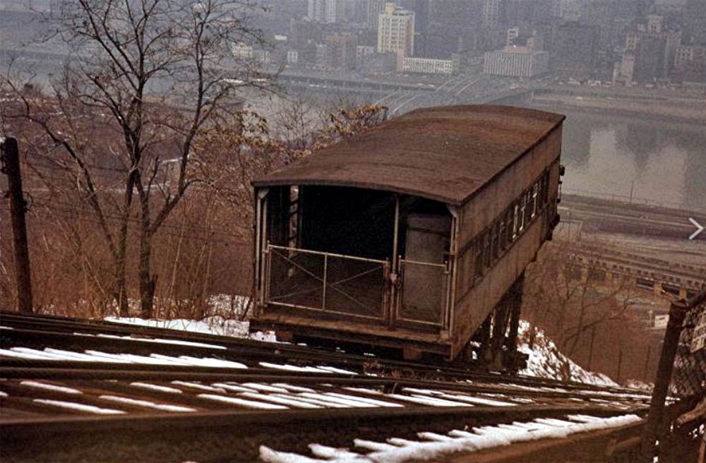
The Monongahela Incline in 1972.
 
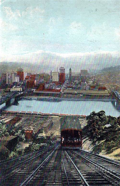
A ride on the Monongahela Incline offers a wonderful view
of the city and the Monongahela River.
 
A view from the lower station looking up (left)
and the Monongahela Incline comes down over McArdle Roadway.

The Monongahela Incline's thirty-eight percent
grade is the steepest in the world.
 
The passenger cars were built specifically
for the Monongahela Incline.
 
The upper station along Grandview Avenue (left)
and the lower station along Carson Street.

The P&LERR Terminal Building and the
Monongahela Incline.
 
The sign at the entrace to the lower station
and the Monongahela Incline at night.
 
The Monongahela Incline is one of Pittsburgh's
main tourist stops.

The Monongahela Passenger and Freight
Incline scaling the Mount Washington slope in 1908.
See More on the Monongahela Incline
Wikipedia: Monongahela Incline.
The Duquesne Incline
(1877-present)

The Duquesne Incline, built in 1877 and shown
here in 1908, has been transporting passengers for over 135 years.
 
The Duquesne Incline celebrates Pittsburgh
Steeler Deee-Fense (left); A view of the entire incline from top to
bottom.
 
The brilliant colors of the Duquesne Incline
stand out with a light dusting of snow.

The Duquesne Incline in 1926.
 
The decorative inside of the Incline car
(left) and a view of the incline rising towards Duquesne Heights.
 
The lower station along Carson Street from
ground level and from above.

The fully-restored Duquesne Incline rises along
the slopes of Mount Washington.
 
The Duquesne Incline, like the Monongahela
Incline, is one of Pittsburgh's #1 tourist destinations.
 
Looking up from the lower station (left)
and a view down towards Carson Street.

The Duquesne Incline provides a stunning view
of the Golden Triangle in this early evening photo from January 2013.
See More on the Duquesne Incline
Wikipedia: Duquesne Incline.
The Keeling Coal Incline
(1870-1928)

Looking up Birmingham (Brosville) Street towards
the upper platform of the Knoxville Incline, the tracks of which can be
seen to the right. Just to the left of center is a building of the Keeling
Coal Company, near the mine shaft entrance.
The tracks leading to the left carried coal directly to the upper loading platform
of the Keeling Coal Incline.
 
The Keeling Coal Incline was built around 1870,
linking mines along the Southside Slopes with the railroads on the flats.
The incline was located between the Mount Oliver and Knoxville Inclines. The plane
was closed around 1928. Coal
was transported straight from a mine shaft to the upper loading platform. The
cable cars then descended
along tracks that went under Birmingham (Brosville) Street and on to an elevated
platform, where
the coal was dumped into rail cars of the Pittsburgh, Virginia and Charleston
Railway.
These two photos were taken around the turn of the 20th century.

Another turn of the century look at the Mount Oliver
and Keeling Coal Inclines, shown from the base of the Knoxville Incline.

1923 Hopkins Map showing the Knoxville, Keeling Coal
and Mount Oliver Inclines along the South Side Slopes.
Wikipedia: Keeling Coal Company.
Bellevue and Davis Island Incline
(1887-1893)

1886 Map showing the path of the Bellevue and Davis
Island Inclined Plane.
Bellevue Borough, located along the Ohio River
just west of Allegheny City, was incorporated in 1867. As the borough grew, the
Pittsburgh, Fort Wayne and Chicago Railroad, which ran along the banks of the Ohio,
provided commuter service to Pittsburgh and Allegheny City. The train had local stops
at Bellevue and Neville Stations, both located along the riverfront at the bottom of
a steep bluff.
The Bellevue and Davis Island Inclined Plane
Company was chartered by the Commonwealth of Pennsylvania on September 4, 1882.
The charter granted the company the privilege of building an incline anywhere along
Bellevue's entire boundary with the Ohio River, the purpose of which would be to
bring passengers up the bluff and transport them to the center of the
borough.
The Street Railways Journal announced the
September 1887 opening of the new transit system in their October issue. Despite the
name, the system now in place was not a traditional inclined plane, or funicular,
as the title implies. It was actually the combination of an outdoor elevator and a
short electric street railroad that ran along the borough's western boundary, rising
gradually in elevation as it proceeded along the half-mile track.
The incline's lift was built near the Bellevue
Station in the vicinity of the now abandoned Davis Island Dam. Passengers would walk
a short distance from the train loading platform to a steel outdoor elevator which
would carry them about eighty-five feet up to the top of the bluff.
From there, the electric street railroad
took them along a twisting uphill ride along the eastern edge of Dilworth Ravine. The
car then traveled along a straight stretch of Sherman Avenue (currently South Jackson)
Avenue to a passenger station at Lincoln Avenue.

The inclined plane company also leased twenty
acres of land at the top of the bluff overlooking the Bellevue Station on which it
planned to build Windsor Park. The summer picnic and recreation resort would be lighted
in the evening with twenty electric lights supplied by the rail car system. It would
also feature a zoological garden. Attempts to exhibit a few wild deer failed when the
animals escaped.
The two cars of the street railroad were
powered by electricity supplied by a third rail located between the main rails, known
as the Fisher System. Manufactured by the Detroit Electrical Works, this electric
railway portion of the inclined plane was the first of its kind in Western
Pennsylvania. The cars were powered by a 100 horse-power engine supplied by the
Westinghouse Machine Company.
The electric motors were mounted on the front
platform of the car, uncovered. A motorman sat on a small stool in front of this motor.
When an unusual load was put on the motor, huge streams of sparks and flames leaped
from the brushes along the third rail and the startled motorman would leap back into
the aisle of the car.
The cars ran relatively smoothly except for
along the sharper curves with a heavy load, when the motor could not provide enough
power and the wheels occasionally got stuck along the rails. The commuters called it
the "G.O.P." system because when the cars got stuck along curves, all of the men "got
out and pushed" the car around the curve.
At first the inclined electric railway was
a greeted with much fanfare. Development in the area was stimulated and property values
saw a modest increase. The jubilant response soon turned sour as mismanagement of the
line led to a rapid decline in ridership.

Aerial image of Bellevue showing former path
of the Bellevue and Davis Island Inclined Plane.
The Bellevue and Davis Island Inclined Plane was
in operation for less than two years, closing in March 1889. The company assets were
sold for $25,000 at sheriff's sale a month later. The new management firm planned to
reopen the system on April 1, 1890, but by that time public sentiment had turned against
the road.
The Pittsburgh Dispatch, on March 20, reported
plans to boycott the road. "Is is reported that the Bellevue and Davis Island Dam
Railroad will be boycotted when it starts on April 1. The former patrons of the road,
who have been compelled to walk ever since it shut down at the beginning of the winter
season, intimate that then can do so during the summer also."
While the owners attempted to prop up their
Windsor Park investment, the elevator was put back in service. The electric railroad,
however, remained idle. The Pittsburgh Disptach reported that the entire line was put
back in operation on April 7, 1891, but it was shut down again after a brief run,
again due to low patronage. Local transportation improvements doomed the incline and
the system was dismantled in late-1893.
Following the erection of the Jacks Run Bridge
and the curving extension of California Avenue that joins the bridge to Lincoln Avenue,
the Pleasant Valley Street Railroad Company began passenger service between Bellevue and
Pittsburgh on March 02, 1893. This street railroad provided service to the center of
Bellevue and significantly reduced the number of local passengers using the Pittsburgh,
Fort Wayne and Chicago Railroad, eliminating the need for the Bellevue and Davis Island
elevator and electric railroad.
 
Remnants of the Bellevue and Davis Island Incline's
eighty-five foot elevator that carried
passengers from the railroad station uphill to the electric railway system.
Remnants of the Bellevue Incline are still visible.
The rail bed can be seen along the eastern slope of Dilworth Ravine. It is clearly visible
with the exception of a few spots where it was eliminated by more recent
development.
The stone walls at the top and bottom of the elevator
are also still clearly visible on the east side of Dilworth Ravine slightly north of where
the Bellevue Station once stood. The wall at the top of the elevator remains intact, and the
bottom is mostly in place except for some minor landslide damage at the south
end.
* Thanks to Dan McCarthy for his
research on the Bellevue and Davis Island Incline *
The Norwood Incline
(1901-1923)
 
The Norwood Incline, shown here in 1908, was located
in McKees Rocks. It operated from 1901 to 1923, and was
referred to as "The Penny Incline," charging passengers one cent to get from
Island Avenue
to Norwood Place. The incline ran on only three rails.
Wikipedia: Norwood Incline.
The Fort Pitt Incline
(1882-1906)

The Fort Pitt Incline rises from near
the north end of the South Tenth Street Bridge to Bluff Street in 1905.
The Fort Pitt incline rose from Second Avenue
at the Tenth Street Bridge to Bluff Street. Built by Samuel Diescher in 1882, it rested
on solid ground from top to bottom with a total length was 375 feet and a vertical rise
of 135 feet.

Map from 1890 showing the Fort Pitt Incline.
The track gauge was ten feet and the rails laid
on cross ties with rock ballast, like a surface road. The cars were built of iron and
could lift up to fifteen tons. The incline was operated using two hoisting ropes, one
and one-half inches in diameter and one safety rope of the same size. The cost of
construction was $98,000.

In 1919, the Bluff Street Steps were built
along the path
of the former Fort Pitt Incline.
Wikipedia: Fort Pitt Incline.
The Clifton Incline
(1895-1905)
From the Allegheny City Historic Gallery:
"The Clifton Incline ... Finally A Look!"
 
Looking down the Clifton Incline in 1902 (left). The
Clifton extended from Clifton Park in Perry Hilltop to Charles Street
at Sara (Strauss) Street; The two-car system carried passengers in one car and stones
in the other car for balance.

Map from 1901 showing the Clifton Incline, rising from
Myrtle Street to Clifton Park on Perry Hilltop.
Wikipedia: Clifton Incline.
The Nunnery Hill Incline
(1887-1899)

The Nunnery Hill Incline was the first incline in
Pittsburgh with a curved track, followed later by the Knoxville Incline.

A 1887 photo of the Nunnery Hill Incline showing
designer Samuel Diescher standing near the top.
Ascending Nunnery Hill from Federal Street on
the line of the Pleasant Valley railway, the incline was built in 1887 by Samuel
Diescher. It was used for passengers only, with a total length of 1,100 feet and a
rise of about 300 feet. The grade of the wooden trestle incline ranged from sixteen
to twenty-six percent, and there was a seventy degree curve in the path of the plane.
The cars held twenty-four passengers. A single fare on was five cents, and tickets
are were in packages of seventy-five for $1.50. The cost of the incline
was $90,000.

Map from 1890 showing the Nunnery Hill Incline in Fineview,
the first Pittsburgh Incline with a curved track.
Wikipedia: Nunnery Hill Incline.
The Troy Hill Incline
(1887-1898)

Map from 1890 showing the Troy Hill Incline near the
30th Street Bridge.
The Mount Troy Incline, which starts at
the Allegheny end of the Thirtieth Street bridge and climbs Troy Hill, was
built in 1887 by Samuel Diescher. The total length was 370 feet and the grade
forty-seven percent. The tracks were partly laid on the ground and partly on
wooden trestles. The incline handled both freight and passengers with a fifteen
ton capacity. The cost of the incline was $94,000.

The location of the Troy Hill Incline is shown here in this
1920 photo taken from the 30th Street Bridge. Available maps
indicate that the structure may have always been an open air incline, both top and bottom,
with only small toll booths.
The Island Hotel was built at the same time as the incline, in 1887. The
upper building shown in this 1920 photo
is a theatre purported to be the original upper loading platform. The location is correct, but
the building first appeared on maps years after the incline was abandoned in 1898.
Wikipedia: Troy Hill Incline.
The Jones And Laughlin Coal Incline
(late-1800s)

Map from 1872 showing the Jones and Laughlin Coal
Incline along the South Side Slopes between
29th and 30th Streets. Coal was transported directly to the riverfront mills.

This 1876 illustration shows the American Iron Works
(J&L) along the South Side Flats at 31st Street,
and the Jones and Laughlin Incline on the hillside delivering coal directly to the
factories below.
The Ridgewood Incline
(1889-1900)
From the Allegheny City Historic Gallery:
"Uncovering A Lost Incline - The Ridgewood"

Map from 1890 showing the Ridgewood Incline. The
Perry Hilltop incline
burned down after only one year of service.
The Ormsby Gravity Plane
(1844-1878)

Map from 1872 showing the Keeling Coal Company's
Ormsby Gravity Plane.
 
The Ormsby Gravity Plane was located along
the Southside Slopes, connecting to a narrow-gauge railroad (left) that
ran along 21st Street to the Jones and Lauglin Steel Mills. The coal incline ran from
the mid-1800s to 1878.
Wikipedia: Keeling Coal Company.
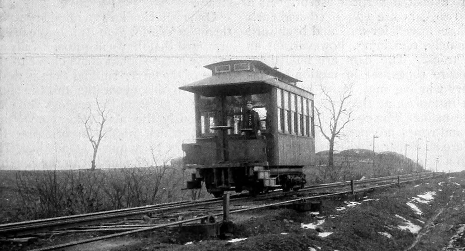
The St. Clair Incline
(1886-1935)

The St. Clair Incline is shown here in a photo
taken by Philip Reinhart on his way to work
at the J&L Mills, and submitted by Philip's great grandson Mike Callahan.
The St. Clair Incline rested on solid ground,
rising from Josephine Street on the South Side to the summit of the bluff at St. Clair
Village. built in 1886 by J. H. McRoberts, it was 2,060 feet in length with a rise of
361 feet.
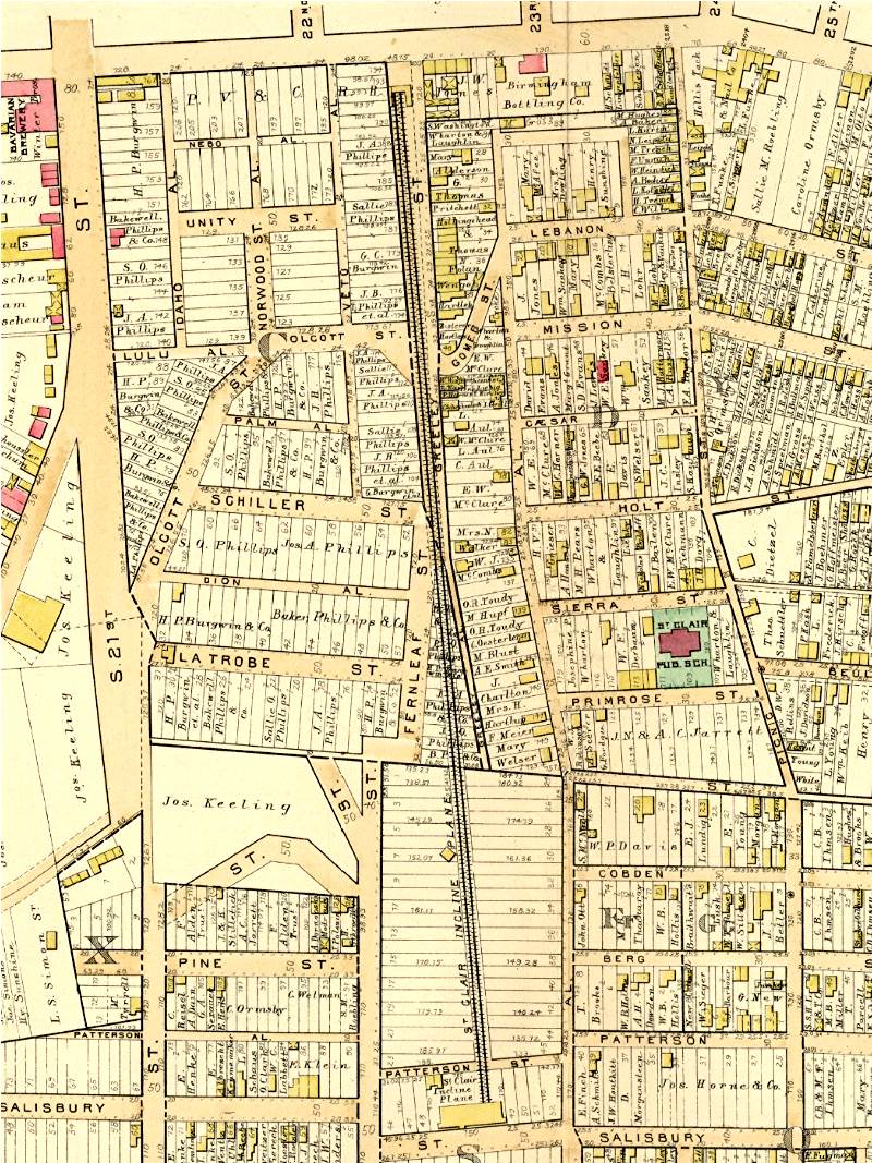
Map from 1890 showing the St. Clair Incline. The incline
was built in 1889 and transported passengers
and freight from St. Clair Village to a lower stationa at Josephine Street.
This South Side funicular was used for both
freight and passengers. The track gauge was seven feet and the rails were forty-five
pound steel T, spiked to white oak ties. The lifting capacity was twenty-five tons.
The cost of this incline was about $60,000.

A photo of the lower station of the St. Clair
Incline after a fatal accident in 1909. Two people were
killed when the car on the left plunged from the top station and crashed into
the lower. This is the
only photo that can presently be found of the Saint Clair Incline, which operated
until 1935.
Wikipedia: St. Clair Incline.
Clinton Iron Works Coal Incline
(late-1800s)

Map from 1872 showing the Clinton Iron Works Coal Incline,
located along Mount Washington, slightly west
of the present-day Wabash Tunnel. It transported coal directly to the Clinton
industries located along the Monongahela riverfront.
Kirk Lewis Coal Incline/Hoist
(1854-1870)

Map from 1872 showing the approximate location
of the Kirk Lewis Coal Incline/Hoist. The incline was named
after mining pioneer Abraham Kirkpatrick Lewis. Coal came directly
from a mine entrance on the hillside,
was lowered to the railroad below, then moved directly to the numerous glass,
steel and iron works
located along the Ohio River flats via the Pittsburgh, Cincinnati
and St. Louis Railroad.
Cray And Company Coal Incline
(late-1800s)

Map from 1872 showing the Cray and Company Coal
Incline on the West End along Saw Mill Run Creek.
The Kund and Eiben Incline
(1915-1929)
 
The concrete foundation of the Kund and Eiben
Incline, abandoned in 1929 after operating for fifteen years.
The standard historical truth here in
Pittsburgh is that there were twenty-three inclines dotting the hillsides around
the city and surrounding area.
We believe we have found the twenty-fourth,
a little known company incline in the South Hills that moved cargo along Oak Hill,
as did the more notable company coal inclines of the past along Mount Washington.
For fifteen years, this lift operated without much notice given to any historical
significance.
The Kund and Eiben Incline, built in 1915,
was a short incline owned by the Kund and Eiben Manufacturing Company. It was
located along Saw Mill Run in Bon Air, just across the tracks from Brookline.
Kund and Eiben operated a Wood Planing Mill alongside the creek near Bausman
Street. The hoist moved materials to and from the P&WVRR freight cars atop the
hill.
The top of the Kund and Eiben Incline stood
next to the Pittsburgh and West Virginia Railroad tracks on the hillside high above
the creek. Originally the lift was used to move raw and finished wood products and
later materials for a concrete fabrication plant along the valley floor. There are
no old photos of the incline or any information on the exact operating
mechanism.
The Kund and Eiben Incline was dismantled in
1929 after the construction of Saw Mill Run Boulevard. The large concrete foundation
has remained abandoned along the hillside. Normally covered in dense foilage, the
foundation is quite visible in the winter months. The dates for operation of the
incline are estimates and based on the maps and information available.

Map from 1916 showing the position of the Kund
and Eiben Incline along Saw Mill Run
in Bon Air. The little-known incline was in operation for nearly fifteen
years.
|