|
History of Coal Hill * Last Updated: November 13, 2018 *
Mountain Of Sliding Banks The communities of Duquesne Heights and Mount Washington stand atop Coal Hill (now refered to as Mount Washington), a 600-foot mountain with a tree-covered cliffside that borders the Monongahela River, creating one of Pittsburgh's most unique and striking vistas. With vintage, historic inclines scaling it's steep facade and the Grandview Park overlooks providing a world-renowned view of the Golden Triangle and the Three Rivers, Mount Washington is now one of Pittsburgh's key tourist attractions. Property along Grandview Avenue, which runs the length of Mount Washington, is some of the most sought-after in the city. This was not always the case. Mount Washington has a long history, full of geological and economic ups and downs. The Indian name "Monongahela" means, "mountain of sliding banks," making reference to the geological features of the hill. Early settlers and travelers marveled at the tree-covered natural barrier to the north, and soon learned the bountiful secrets of the Pittsburgh Coal Seam hidden beneath the surface. As the city industrialized, the mountain became the source that fueled Pittsburgh's growth. By the late-1800s, annual coal production was 13 million tons. The rich coal seam, which extended the length of the Monongahela and Ohio, has been deemed the most commercially valuable mineral deposit in North America. Although mining in Pittsburgh ended years ago, the legacy of Coal Hill will forever be tied to the black gold that flowed from it's veins.
By the end of the 19th century, the ravages of time, the scarring from the mining operations and the destructive forces of modern industry had transformed the once-forested hillside into a barren, eroding wasteland. Property values plummeted and the entire image of the city of Pittsburgh suffered as a result. The 20th century saw a gradual increase in efforts to reduce, and subsequently reverse, the deteriorating condition of the hillside. The city began by designating the area as green space and park land. Through the determined efforts of the City Department of Parks and Recreation and the City Planning Commission, along with numerous local community and civic groups, Coal Hill has been transformed back into the lush, tree-covered vista that once thrilled early travelers like the young British officer named George Washington.
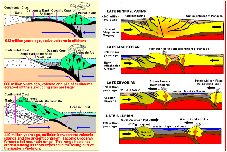
The following is a short history of Coal Hill, written in the 1980s and brought up to date. The article was discovered online at the Western Pennsylvania Conservancy webpage and has been edited to bring it up to date. It provides some interesting insights into the evolution of Pittsburgh's historic Mount Washington. Geological Origins of “Coal Hill” The origin of Mount Washington, or Coal Hill, goes back to a period of time known as the Taconic Orogeny. The unusual exposed coal deposits along Pittsburgh’s Coal Hill were the result of tremendous shifts in the earth’s crust beginning more than 435 million years ago. During this episode of mountain building, North America was crashed into by a chain of volcanic islands. The land folded, buckled and lifted to form new mountains in the eastern part of the state while depressing a basin in the central part of the Pennsylvania plateau. Over the next 30 million years the Taconic mountains were eroded, and vast quantities of sediment were carried into the central and western part of Pennsylvania. These sediments were deposited in the huge Catskill Delta, where sedimentary rocks were formed to a depth of 4,000 feet. Deposits 1,500 feet thick were made in Erie. This delta covered an area from New York through central Pennsylvania.
A second mountain building period, called the Acadian Orogeny, formed more mountains to the east, providing even more sediment to enlarge the delta. Finally, the Alleghenian Orogeny occured some 300 to 220 million years ago, during the collision of North America and Africa. The sediments washed from this set of mountains created the sedimentary rocks that can now be seen on the surface of much of the land in western Pennsylvania today. Pittsburgh sits on over 16,000 feet (more than 3 miles) of sedimentary rock. During this Pennsylvanian Period (300 to 220 million years ago) Pittsburgh was under swamps with a hot equatorial climate that supported lush plant growth. These plants provided the raw materials, later transformed by bacteria, pressure and heat into bituminous coal, that underlies Mount Washington and much of the rest of western Pennsylvania. Early Colonial History and The Siege of Fort Pitt The European powers that battled for control of the region focused their attentions on the junction of the Three Rivers. The location was perfectly situated for a fort, providing excellent defensive barriers on all sides, including the Monongahela River and Coal Hill to the north. First the French, who erected Fort Duquesne, then the British, with Fort Pitt, knew what a formidable obstacle the cliffsides of Coal Hill were to any invading force. On the other hand, control of the heights did offer the enemy a perfect observation point. This was the case in 1763, when an Indian Uprising threatened British control of the entire Northwest. Ottawa Chief Pontiac and his coalition of northwestern tribes took control of several British forts and soon were marching on Fort Pitt and the settlement of Pittsburgh.
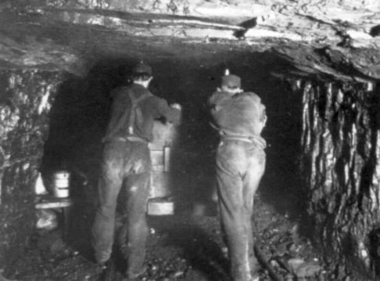
For nearly three months, beginning on May 27, 600 settlers and a garrison of 150 British soldiers were under siege at Fort Pitt. The Indians held the hills ringing the city, including the commanding heights of Coal Hill. The garrison had withstood several attacks and were running short of supplies and ammunition. The siege was lifted on August 20, 1763, only days after a relief expedition under the command of Colonel Henry Bouquet defeated the Indians at the Battle of Bushy Run. After the rebellion had been put down, the growth of Pittsburgh, considered the "Gateway to the West," accelerated at a rapid pace. Coal would be the catalyst that fed that growth. Pittsburgh Industry and the Role of Mount Washington By the latter part of the 1700’s the south side of the Monongahela River had become known for its supply of coal. The first mining of bituminous coal in the nation began on “Coal Hill” in 1762. Early residents of the region gathered the coal to heat their homes and to supply the soldiers at Fort Pitt. Coal was delivered to the fort in canoes. This early use of coal was unusual in the colonies, since wood was the fuel of choice elsewhere.
The Penn family began selling mining rights on Mount Washington as early as 1784. By then, Pittsburgh had already been dubbed “The Smokey City” because of the heavy use of coal. This name was thrust upon the fledgling city long before the roaring iron and steel mills came along in the 19th century to saturate the air with their acrid, sooty discharge. The black gold of Coal Hill was unusually accessible. At one time people could simply loosen the coal at the surface and toss it down the hillside to waiting boats. It sold for a penny a bushel. Soon, mining ventures were drilling deep into the mountain to extract the fuel that fed the growing city and its emerging industrial base. Early industrial uses of coal included salt extraction. By 1825 over 200,000 tons of coal per year were being used in Pittsburgh to produce salt for domestic use. Glass making was established in the 1830’s, and within a few years Pittsburgh was producing more than half of the nation’s total glass. By the 1870s, canals, and then railroads, helped spur the use of coal for iron and steel production. Coal extraction was at an annual 13 million tons, which accounted for one-fifth of the entire national output.
The rich Pittsburgh seam, which extended the length of the Monongahela and Ohio, became the most commercially valuable mineral deposit in North America. Mining enterprises were in operation throughout Pittsburgh and the surrounding boroughs and towns. Small-gauge coal railroads and spur lines criss-crossed the valleys near Coal Hill. Many of these lines, like the Pittsburgh and Castle Shannon Railroad, utilized a network of underground tunnels that themselves criss-crossed through the rock core of Mount Washington. These lines terminated at inclines or loading platforms on the north face. From there the coal would be transported to the factories along the Monongahela riverbank. As the steel industry became one of the coal industry’s largest customers, many of the most famous names in Pittsburgh 19th century industrial history became linked to it's riches. Entrepreneurs and financiers like Seward Hays, Henry Clay Frick, Andrew Carnegie, Henry Phipps, and Thomas Mellon all were part of the industrial engine that made Pittsburgh an economic powerhouse for the nation. Since 1760, more than 1,000,000,000 (one billion) tons of coal have been mined from the Pittsburgh seam in Allegheny County alone. This quantity of coal is equal to the volume of about 3,000 U.S. Steel Buildings, enough to fill 12,000,000 standard rail coal cars and make a train that would extend almost six times around the earth. “Coal Hill” Becomes the Community of Mount Washington While Mount Washington may have been first noted for the abundant coal deposits, its location made it a natural area for settlement in the earliest days of Pittsburgh's burgeoning industrial enterprises, which were primarily farming, ship building and salt production. By the 1860s Pittsburgh's industrial base experienced a large expansion, with the introduction of glass and iron production. This growth required new workers, and the workers needed housing. The nearby hillsides, including Mount Washington and Duquesne Heights, were an attractive option. Slowly, the farmlands at the top of Coal Hill were converted to housing.
The Borough of Mount Washington was annexed into the City of Pittsburgh in 1872. Unfortunately for these new city residents, the steep terrain was difficult to traverse. The mile long switchback known as the Indian Trail Steps, which ran the entire length of the mountain’s face from High Street (Grandview Avenue) to the base of the hill at Carson Street, was a major transportation route for many weary commuting factory workers. Native Germans, using the model of steel roads, or "steilbahns", on the steep hillsides of their native country, proposed the construction of Inclined Planes as a more efficient way of transporting men and material up the slopes. Also called funiculars, inclines had been in use by the coal industry for a few decades, transporting raw material from the mines on the hillsides to factories below. The proposed communter inclines, like the Monongahela and Duquesne Planes, began operating in the 1870s, carrying not only people but also freight, horses and wagons. Their popularity soared and soon several inclines dotted hillsides throughout the city of Pittsburgh.
Environmental History of Mount Washington Views of the Mountain The earliest descriptions of the Mount Washington area by travelers provide a testament to its original beauty and riches of its landscape. The dramatic vista sculpted by the three rivers was lushly wooded, both productive and scenic. Numerous accounts describe the thick and diverse tree cover along the hills, as well as the clear water, abundant fish and prosperous farmlands. In 1754, George Washington, a British Major sent as an emissary from Governor Dinwiddie of Virginia to the French encamped at Fort LeBoeuf on French Creek, noted that the land at the junction of the Allegheny and Monongahela Rivers was “extremely well situated for a Fort; as it has the absolute command of both Rivers. The land at the Point is a considerable bottom of flat, well-timbered land all around it very convenient for building.” In the late 1780s, Justice Hugh Henry
Brackenridge wrote lyrically of his experience of Pittsburg and compared it
favorably with many other locations. Clearly the land has been converted toward
agriculture in many places: Describing the confluence of the rivers,
he states: In 1806, Irish visitor Thomas Ash also
formed a favorable impression of the area. On a boat ride down the Allegheny
he wrote:
Mrs. Ann Royall visited Pittsburgh in
1828 after it had recovered from the depression caused by the War of 1812 and
had become a center of commerce and manufacture for the region. She wrote
expansively of the splendors of Pittsburgh, including Coal Hill. Among her
notes are these remarks: By 1832, however, when Mr. James Stuart
visited, the tension between exploitation of the riches of the land and the
condition of the environment was evident in his comments: Fourteen years later, in 1846, the
Pittsburgh Chronicle had this to say on the subject of environmental degradation
in the pursuit of coal and industry:
In 1866, Pittsburgh, with its roaring
blast furnaces working round the clock, was described by James Parton as
“hell with the lid taken off.” But in an even truer sense, Mount Washington
itself was literally aflame underfoot. A fire was started accidentally in the
underground coal fields and burned uncontained for sixteen years. One visitor,
the Reverend Charles Beatty, described his experience on the hill in 1865 or
1866: By the time the inclines were built, much of Mount Washington’s north face was completely bare of greenery. Some sources suggest that the fumes and byproducts of industrialization had poisoned the hillside flora. The forested hillsides of George Washington’s first visit were long gone and the “practical” use of the mountainsides prevailed. In the 1950s, according to an article in the Pittsburgh Post Gazette, the Mount Washington and Duquesne Heights area were characterized as "one of the ugliest industrial cities in the world. Honeycombed with mines, fronted by smoke-belching steel mills at its base and virtually isolated with only a few poor roads servicing it, Mount Washington was hardly a prestigious address."
Geological Features of Mount Washington Forest Types Forest types in Western Pennsylvania were documented by early travelers and others, but only in the most general terms. However, there are a few specific surveys of plants on Mount Washington. Land sold by the Penn family in the 1780s was surveyed using trees as property markers. This included portions of Mount Washington. Mentioned in the surveys were the following trees: Hickory, White Oak, White Walnut, Spanish Oak, Sugar Tree, and Red Oak. A study by the City Department of Parks and Recreation in 1970 cataloged the following trees on Mount Washington: Maples and Locust, with a few Red Oak, Mulberry, Dogwood, Walnut, Ash and Sumac scattered throughout the entire area. The list also included Ailanthus, Malus, Honeysuckle, Box Elder, Hawthorn, Virginia Creeper, Sumac and poison ivy. The report specifically noted the absence of evergreens on the hillside. Undergrowth, weeds and small trees were found to be adequate for controlling erosion throughout most of the area. Fisheries Early descriptions of Pittsburgh's fisheries speak highly of the quality of the water in the rivers. In this well-watered region fish were naturally abundant: trout were found in the tributaries of the Allegheny, perch and pike in the streams flowering into the Monongahela. The three great rivers also included catfish, sturgeon, bass, and bullheads. Turtle, eel and the “Allegheny alligator fish” are also recorded by early travelers. However, development of the flats near the rivers, including dredging and filling, and polluted runoff from mining and other industrial operations, led to large fishkills and other signs of degraded water quality in the 1950s. The impact of decades of industrial exploitation in the surrounding hills had created a toxic environment that destroyed Pittsburgh's once abundant fisheries. Soils The 1970 study for the Department of Parks and Recreation describes the soils in the Mount Washington-Duquesne Heights area as “variable” over relatively short distances due to the steepness of the slope. A 1971 Grandview Study by the City Planning
Department provides some insight into soil conditions on Mount Washington: LANDSLIDES - The steep slope areas of Mount
Washington have been formed by erosion and are in the process of erosive change at
the present time. These areas can be considered as generally unstable and subject to
landslides, rock falls, and other types of geologic movement, a condition that has
existed since the days of the earliest settlers. GEOLOGIC FISSURES - The horizontal strata
exposed on the steep hillsides in the Mount Washington area are dissected by a
series of parallel and near vertical fissures. The fissures occur throughout the
steep hillsides facing both the Monongahela River and Saw Mill Run Creek. These
fissures are a result of removal of lateral support by the erosion which formed
the hillside and adjacent valleys. Removal of this support has caused immense slabs
of bedrock to move toward the center of the valleys. These fissures are largest
and most frequent near the faces of the hillsides and gradually diminish in both
size and number away from the slope. They are visible in the hillsides, especially
where some recent movement has occured. They become natural channels and carry
large volumes of water draining through the hill. This water can exert hydrostatic
pressure, which aggravates an already serious stability condition. These fissures
are the planes of weakness along which landslides and rockfalls have usually
occurred in the past and will continue to occur in the future. WEATHERING AND EROSION - The on-going,
natural weathering processes of the area are generally very gradual and there
are elements that work to control erosion. Plants on the steep slope area
have a stabilizing influence, tending to retard erosion, in addition to presenting
a green façade to the hill. Any intervention into the harmony of this ecology
should be done with due consideration or an undesirable situation may be created.
Thirty years ago the local air was so polluted that much of the plant life on the
north façade of Mount Washington was poisoned. The sparse growth presented
an unnatural condition that accelerated erosion. This condition offered
a much less desirable façade as well. Fortunately, nature has restored much
of the plant growth. Periodic excavations in connection with railroad or highway
construction have also scarred the hillsides in such a way that nature has not
been able to restore vegetation. The excavation for the portals of the Fort Pitt Tunnels have removed plants and top soil and has exceeded, to a critical
degree, the natural slope of the hill. This presents a serious problem with regard
to planting and erosion control. The report included a strongly-worded
assessment of land conditions on the north side: Hillsides, Green Space
and Parks In the early part of the 20th Century, there was
considerable activity focused on the livability of Pittsburgh. Among the reports was a
seven year effort begun in 1918 and completed in 1923, to review six different features
of Pittsburgh, including playgrounds, streets, transit, parks, railroads and waterways.
The central theme of these efforts was that “a good city in which to live makes a good
city in which to do business, and that industrial and commercial progress is largely
dependent upon social and civic conditions.” Facilities such as parks and recreational areas
were considered primarily from the standpoint of their importance to economic conditions,
but there were also social and aesthetic considerations at work in these
reports. J.T. Holdsworth, PhD, introduced the topic of
recreation facilities in his economic survey of Pittsburgh in 1912: Frederick Law Olmstead, in a report to the
Pittsburgh Civic Commission in 1910, said: Olmsted goes on to plea for a careful planning
process: "The basic standards set forth for distribution
and accessibility of parks were generally accepted and used as a basis for the
discussion of desirable parks planning during this period of time. It is proposed that
all families should live within no more than a quarter of a mile or at most half a mile
from playgrounds or local parks that provide for exercise or rest.” "Pittsburgh’s topography creates a special
challenge to planners. The problem of making use of the excessively steep hillsides
in the Pittsburgh District is a troublesome one. There is a great deal of such land
in the district, as much as 30 to 35 percent of the total area. These steeper and
more irregular pieces would be of greater use to the public than they could
be to private occupants." "Although the steep hillsides of Mount
Washington, as isolated fragments, can not meet the local needs for playfields and
outdoor gymnasiums like those in large rural parks, it is possible to lay out
sidehill walks on easy gradients and to furnish seats and terraces, especially near
the upper edges, where the people of the neighborhood can stroll or rest and enjoy
interesting and extensive views of the city, the river or the adjacent valley, always
with the steep natural hillside below as a foreground. "In flatter landscapes, fewer and larger parks
can serve a large number of people. In a hilly terrain, in which the hills themselves
present physical barriers to travel, a park on one hillside may not be accessible to
someone living nearby." In an eloquent plea for Pittsburgh to take
advantage of its visually remarkable location between the rivers, Olmstead specifically
included this comment about Mount Washington: Economic Benefits of Parks and
Recreation The Pittsburgh Plan, crafted between 1918 and 1923,
titled section II of its report on parks and recreation “The Social and Economic Value of
Recreation” and started the section with these entries:
"Recreation is an essential human need. It is vital to both the individual and to the
community as a whole. Human beings, as well as plants, thrive out of doors. Open spaces
are the city’s lungs. They are breathing places. They may be used as playgrounds for the
children or as athletic centers for both children and adults. They may consist of large
parks and boulevards, formal or informal city “squares” and neighborhood parks, or water
recreation areas. As the city grows, the need to provide such open spaces becomes more
frequent and urgent. This is a fundamental issue." "In the past, Pittsburgh employers have been
handicapped because workers were attracted to other cities which offered more and better
recreation facilities than this city could offer. If the aggregate time annually
available in this city for recreation were expended wholesomely and healthfully, even
if very great expenditures were required to provide facilities for that purpose, there
would be an incalculable economic return. The effort would be an investment in
public health, contentment, efficiency, and in better citizenship. The Pittsburgh Plan suggested future action to
increase the availability of locally accessible green spaces to “meet the needs of the
masses” including the following idea: Recreational Park and Greenway
History Grandview Park was acquired in 1897 and
originally contained some eighteen acres of hillside land. The park was developed with
a picnic shelter and a merry-go-round which operated until 1946. A music pavilion
was used for concerts in the summer. Grandview Park was used as a base for the
topographical survey of the city. At 1255 feet above sea level, the park is one
of the city’s highest points. An overlook was constructed in 1958 which has been
used as a platform for band concerts and for theatre performances. A local
elementary school is also located within the park. Olympia Park, once farmland, is a compact 9.3
acres on the southern slope of Mount Washington, west of Chatham Village. It
was acquired in 1908, after residents of the area made known their desire to have
a local neighborhood park. It was named Olympia Park in reference to the site of all
public games in ancient Greece. True to its name, the park focused on athletic uses, and
contained a ball field, a sizeable Recreation Center and a playground for young
children. At one time the park also offered a swimming pool and bath house. The
ballfield was flooded in the winter and converted into a skating rink. Mount Washington Park was established in 1908,
again at the demand of local citizens. Once productive farmland, the park was established
with about fifteen acres. It is now just under twenty-one acres of land. Much of the land
is so steep that the park was nicknamed “goat park” by some. The park has also gone by
the name of Wilbert’s Grove and Dilworth Park. The park includes a playing field and a
children’s playground. The Duquesne Heights Greenway is a product of a
decades-long evolution of the concept of protecting Pittsburgh’s steep hillsides and
keeping these areas predominantly green and in city ownership. In 1939 the City’s
Planning Commission took action to preserve the steep slopes and reduce the likelihood
of future development on those sensitive lands. Nineteen years later, in 1958, to
further hinder hillside development, City Council added a new zoning classification
- “S” for special areas including steep slopes. A Riverfront and Hillside Master Plan was completed
the following year and identified future uses for the hillside areas, including overlooks,
scenic drives and conservation and recreation areas. In 1966, then-Mayor Richard Joseph
Barr and the City Council supported the City Planning Commission and the Department of
Parks and Recreation to create a program to acquire the remaining private properties on
steep slopes. In tandem with a state program dubbed “Project 70” that provided matching
funds for land purchases, the City greenway plan identified seven top priority areas,
including portions of Mount Washington. One hundred sixty-six acres of tax delinquent
and private properties were identified for purchase. This thinking was carried into the early 1980’s
during the term of Mayor Richard Caliguiri. Outlining a strategy that still holds promise,
the city planned to consolidate public land, seek gifts of other private properties in
sensitive hillside areas, and hold the clusters of land as undeveloped open space for
passive use. This plan was successful in several city neighborhoods,
including Brookline, were delinquent properties were acquired in the undeveloped Brookdale
subplot, forming a continuous forty acre greenway bordering Brookline Memorial Park. The Duquesne Heights Greenway includes fifty-six acres designated as
greenspace, and another sixty-three acres, primarily undeveloped areas, that border
the park. Grandview Overlook Park includes approximately
fifty acres that stretch along the northern face of Mount Washington, providing the
tree-covered green backdrop to Pittsburgh’s “Golden Triangle”. The view from Grandview
Overlook Park is a famous urban vista that has earned, along with McArdle Roadway and East Sycamore Street, a Pennsylvania Scenic Byway
designation. This park was established in the 1950’s when the Railroad donated the land to
the City of Pittsburgh with a deed restriction for the park's creation. In the 1970’s, federal highway funds were used
to enhance the public space at the eastern end of Grandview Avenue from the Monongahela
Incline to Ulysses Street. At that time the four observation platforms that cantilever
over the hillside from the Grandview Avenue sidewalk were constructed, and new lighting,
fencing, park benches and street trees were also installed. However, the park extends
beyond Ulysses Street to the western end where Grandview Avenue meets Republic Street.
At the western end of Grandview a small section of relatively level land within the park
area was improved with a new sidewalk and a platform for the placement of a statue of
George Washington and Indian guide Guyasuta. In 2005, the Mount Washington Community
Development Corporation unveiled a new Mount Washington park, known as Emerald View
Park, which connects the existing historic park spaces, or anchor parks, with
wooded greenways and a scenic byway with many amenities. The continually evolving,
257-acre uninterupted green space rings the Mount Washington hillsides in a horseshoe
shape, encompassing the northern, western and southern slopes. Emerald View Park
presently contains four miles of continuous walking trails. The master plan envisions
a total of nineteen miles of unbroken trails, to be completed sometime near
2030. History of Hillside
Restoration Attempts For nearly 100 years various attempts have
been made to improve the physical condition of the hillsides of Mount Washington.
Ideas about what would be appropriate aesthetically or ecologically have changed
over time. In his 1910 Study of Pittsburgh, Frederic
Law Olmstead urged the city to pay attention to its hillsides as an integral and
defining part of the local environmental and recreational resources of the region.
Olmstead called the Mount Washington hillside “a monumental example of the
Pittsburgh landscape” and he urged that it should be “preserved intact for all
time.” He specifically urged that the unsightly billboards and damaged areas of the
mountainside be cleared and restored. In a 1912 report on economic development for
Pittsburgh prepared for the City Council and Mayor, Dr. J.T. Holdsworth considered
recreation, parkland and a pleasing physical landscape to be integral to economic
advancement. He supported Olmstead’s recommendations, and added that the “barren slopes
on both sides of the Monongahela should be viewed as opportunities for park expansion.
At comparatively little expense these bleak banks can be converted into neighborhood
parks accessible to the working community where the ever-changing panorama of river
and city life may be enjoyed. By appropriate landscape treatment these eyesores can
be made at once beautiful and useful in contributing to our recreation needs.” A number of program and policy decisions were
made over the next two decades to reinforce the concept of hillsides as a crucial
resource needing care and improvement. In 1928, the City Planning Commission adopted
a Mount Washington beautification plan that would cost $75,000 over three years. The
plan called for 8,000 trees to be planted in one year. The first $25,000 was
appropriated, but the Great Depression ended the follow up efforts. In 1949, a group of citizens led by the local
Chamber of Commerce involved school children in an attempt to plant sunflowers, cosmos,
poppy and cornflower seeds as well as “Easter plants.” A resident of Mount Washington
wrote to all states and territories and requested seeds or plants to start a “Garden
of the States.” Unfortunately, much of this material died, but some of it did catch
on. In 1953, the Women’s Club of Mount Washington
asked the City to get involved. City Council allocated funding to clear weed trees
along the Mount Washington Roadway. Mrs. Verna Dibble undertook the first of a decade
of Arbor Day events to help coordinate efforts to beautify the hillsides. In the fall
of 1953, a large number of maple sugar seeds were collected and scattered on the
hillside. In the spring of 1954, the City Parks
Department planted over 100 crab apple trees from one to five feet tall, three bushels
of hawthorn seeds, some black locust and honey locust trees. In the fall of that same
year, the City planted multiflora roses donated by the Dormont-Mt. Lebanon Sportsman’s
Club. The Mount Washington Hillside Planting Committee collected funds for additional
plantings. In the spring of 1955 this group purchased another 100 trees and shrubs,
including Sassafras, Arrowwoods, Mountain Laurels and Azaleas. A 1959 study for the Department of Parks and
Recreation and the Department of City Planning outlined a master plan for the city’s
riverfront and hillsides. In 1965, an article in the Post Gazette featured a test
planting on the hillside side near the Fort Pitt Tunnel. A lawn care company offered
to test a new method of spreading seed and tested a mix of rye grass and Crown
Vetch. In 1970 the City Parks and Recreation Department
commissioned studies to assess the potential for restoring Mount Washington, an
area the study called “The largest single element of Pittsburgh’s magnificent topographic
personality.” Their detailed recommendations led to an experimental test planting
commissioned by the Mount Washington Hillside Planting Association. Also involved were
the Western Pennsylvania Conservancy and the Hillman Foundation. Newspaper coverage at the time explained the
following plans: In five areas, encompassing vertical cliff, level areas, 45-degree
slopes, bare rock, open field, light cover and dense forest, the plan was to plant
both “introduced” and native plants. In level spots, the following were to be
planted: thirty-six trees, including Sugar Maple, Yellow Buckeye, Shagbark Hickory,
American Beech, Tulip Poplar, Red Oak, Chestnut Oak, Hackberry, White Pine, Basswood
and Canada Hemlock. On steep slopes, fifty seedlings of Beech,
Buckeye, Pine, Hemlock, Red Oak and Sugar Maple were planted. In a clearing, shrubs
including Mountain Laurel, Pinxterbloom, Fragrant Sumac, Mapleleaf Viburnum, Spice
Bush and Arrowwood were tested, along with Crown Vetch. On downward slopes, seedlings
of White Ash, Tulip, Sassafras, Basswood, Red Pine, Hackberry, White Ash, Scarlet Oak
and ground cover were tried. On other slopes, Red Maples, Sugar Maples, White Ash,
Red Oaks, Scarlet Oaks and Chestnut Oaks were planted. Finally, beside the incline,
ninety-six cover plantings were added, including Trumpet Vine, Virgin’s Bower,
Trumpet Honeysuckle, Virginia Creeper, Kudzu Vine, Fox Grape, and Bittersweet. In 1980, a follow-up survey to assess the
efforts to hide the Fort Pitt Tunnel scar was evaluated. It was found that several
of the seedlings and shrubbery had taken root and suggested additional measures, such
as the hanging of special gardens that would function to provide more stability to the
oft-crumbling slopes. Over the next three decades efforts continued
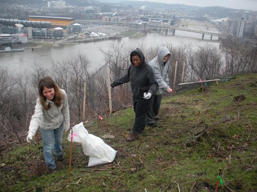
on a regular basis to carry on the work of maintaining and enhancing the slopes of
Mount Washington. Community groups conduct yearly clean-up efforts and tree plantings.
Years of hard work have gone a long way towards restoring Coal Hill to it's past
glory. The future of Mount Washington, however, depends on the continued efforts of
the city, conservationists, and concerned friends and neighbors. The Beauty of Mount Washington
Recaptured What began in the early 1900s as a determined
effort to turn the tide of the degradation and erosion of Pittsburgh's dominant
geological feature, the imposing heights of Coal Hill, has done wonders to return
the hillside, and the hilltop communities of Mount Washington and Duquesne Heights,
to prominence. The introduction of recreational facilities and the reforestation of
the slopes has made considerable progress in restoring the natural beauty
of the Pittsburgh landscape and providing the citizenry with several historic and
picturesque parks. High Street, now scenic Grandview Avenue, is
known around the world as the overlook drive that offers the golden views of
Pittsburgh's Golden Triangle, situated majestically at the junction of the Three
Rivers. The roadway is lined with upscale homes, luxury apartments, five-star
restaurants and, of course, the upper loading stations of the historic 19th
century Monongahela and Duquesne Inclines. Along the Mount Washington slopes, the process
of evolution has come full circle. The lush, tree-covered hillside that so impressed
early travelers like young George Washington in the 18th century is, once again, as
Mrs. Ann Royall wrote in 1828, "a point of interesting observation where the eye at
a single glance takes in a hundred beauties that might view with the purest and
brightest of other hemispheres." And, as the Pittsburgher of the 21st century knows
so well, the view from the top of the hill is incredible! |